Explore Cyprus with Our Interactive Map

Explore our top stories and discover ideas worth your time.

St. Hilarion Castle

St. Hilarion Castle

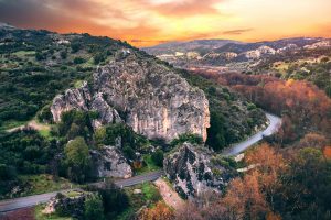
St. Hilarion Castle stands 732 meters above sea level in the Kyrenia mountain range of Cyprus. This medieval fortress features stone walls and towers that appear to grow directly from the rocky peaks. Located just off the main Kyrenia to Nicosia highway, the castle commands the mountain pass between the coast and the central plain. The castle is the best preserved of three Byzantine strongholds built along the Kyrenia mountain range, the others being Kantara to the east and Buffavento further west. The fortress consists of three main sections built at different elevations on the mountainside. The lower ward contained stables and living quarters for soldiers. The middle ward housed royal apartments, kitchens, a church, and a large cistern for water storage. The upper ward, surrounded by 1.4-meter-thick Byzantine walls made of rough masonry, served as the royal residence and includes Prince John's Tower perched on a rocky cliff. Historical Background The castle takes its name from an obscure Christian hermit who fled to Cyprus after the Arab conquest of the Holy Land in the 7th century. This saint, known for living in a cave on the mountain, is not the same as the more famous St. Hilarion, who was active in Palestine and died near Paphos in 371 AD. Local tradition holds that the hermit spent his final years…

Read more
Akrotiri Peninsula

Akrotiri Peninsula

\nThe Akrotiri Peninsula in the Limassol District marks the southernmost tip of Cyprus and also the southernmost part of Europe. This 123 square kilometer area contains the largest complex of natural wetlands on the island, centered around Akrotiri Salt Lake.\n\n\n\n \n\n\n\nThe peninsula hosts over 300 recorded bird species, more than 800 indigenous plant species representing roughly 40 percent of all plants found on Cyprus, and critical habitats ranging from coastal sand dunes to Mediterranean juniper forests. Most of the peninsula lies within the British Sovereign Base Area of Akrotiri, territory retained by the United Kingdom when Cyprus gained independence in 1960.\n\n\n\n\n\nFrom Ancient Island to Protected Reserve\n\n\n\nThe Akrotiri Peninsula was once a small island that merged with the rest of Cyprus through processes spanning thousands of years, creating what geologists call a double tombolo. The Kouris River carried sediment to create a land bridge on the western side at least 56,000 years ago, while the Garilis River later formed a second connection on the eastern side. This gradual process trapped seawater between the two land bridges, forming Akrotiri Salt Lake.\n\n\n\nThe south cliffs of the peninsula, known as Aetokremmos, host the earliest known archaeological site in Cyprus and are believed to be the first part of the island inhabited by people during the pre-Neolithic period.\n\n\n\nThe site contains 12,000-year-old fossilized bones of pygmy…

Read more
Diarizos Valley, Cyprus

Diarizos Valley, Cyprus

The Diarizos Valley stretches through the heart of western Cyprus, where ancient traditions meet rare wildlife in one of the island's most important conservation zones. Located east of Paphos and carved by the fourth-longest river in Cyprus (Diarizos River), this valley combines ecological significance with centuries of winemaking heritage across 14 traditional villages. The area covers 8,804 hectares and serves as both a Natura 2000 protected site and an Important Bird Area recognized for its unique biodiversity. The Diarizos River flows for 42 kilometers from two sources on the southeastern slopes of the Paphos Forest near Mount Olympus. Its name derives from the Greek word for two roots, referencing the Platys and Kaminaria tributaries that merge north of the historic Tzelefos Bridge to form the main river channel. Unlike most Cypriot rivers, the Diarizos maintains water flow throughout all seasons, making it one of only five permanently flowing rivers on the island. The river basin extends across 278 square kilometers between the western slopes of Mount Olympus at 1,951 meters elevation and the Paphos Forest peaks. The elevation gradient ranges from 800 meters near the source down to 50 meters where the river approaches the Paphos plain before reaching its Mediterranean outlet near Kouklia village. This dramatic descent creates varied habitats that support different plant and animal communities at each…

Read more