Street Arts Music Festivals
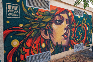
Cyprus is often described through its beaches and ancient monuments, but some of the island’s most revealing cultural moments happen in public streets, squares, and parks. Across cities and towns, music spills into old neighbourhoods, walls become canvases, and everyday spaces are temporarily reshaped by performance and visual art. Street arts and music festivals offer a direct way to experience modern Cypriot creativity as it is lived, shared, and shaped in real time. Rather than separating culture from daily life, these events place it exactly where people already are. When the City Itself Becomes the Venue What distinguishes Cyprus’s street arts and music festivals is not scale, but placement. Performances rarely stay confined to formal halls. Instead, they unfold across pedestrian streets, municipal gardens, historic squares, waterfront paths, and occasionally repurposed industrial sites. The city is not just a backdrop. It is part of the performance. This approach changes how people experience art. Audiences do not arrive, sit, and leave. They move, pause, follow sound, and discover things unintentionally. A concert might lead into a street theatre scene. A mural might become the focal point of a gathering. Culture becomes something encountered rather than scheduled. From Traditional Gatherings to Contemporary Festivals Public celebration has long been part of Cypriot life. Village festivals, religious feast days, and seasonal events once structured…
Read more