The Mediterranean Chameleon
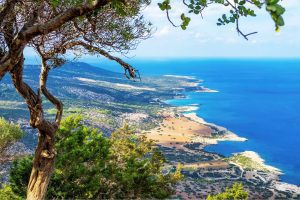
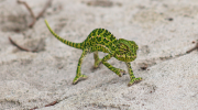
Hidden among the reeds, olive groves, and coastal bushes of Cyprus lives one of the island’s most unusual animals: the Mediterranean chameleon (Chamaeleo chamaeleon). Unlike the island’s snakes and lizards, this remarkable reptile moves slowly, watches the world with independently moving eyes, and can change its colour in response to its surroundings and mood. Many visitors spend years exploring Cyprus without ever seeing one. Yet this ancient reptile has been part of the island’s natural heritage for thousands of years. Meet the Mediterranean Chameleon The Mediterranean chameleon belongs to an ancient family of reptiles that evolved long before humans appeared. While most people associate chameleons with Africa or Madagascar, Cyprus is home to one of the few chameleon species naturally found in Europe. The Mediterranean chameleon is the only chameleon species living on the island. It spends most of its life among bushes, shrubs, reeds, and low trees, where its camouflage makes it almost invisible. Unlike fast-moving lizards, chameleons rely on patience rather than speed. They move carefully, swaying gently as if they were leaves blowing in the wind, making it difficult for predators to notice them. An Ancient Traveller of the Mediterranean The ancestors of modern chameleons evolved millions of years ago in Africa. Over time, some species spread around the Mediterranean Basin, reaching parts of southern Europe, North…
Read more