Explore Cyprus with Our Interactive Map

Explore our top stories and discover ideas worth your time.

Saranda Kolones Fortress

Saranda Kolones Fortress

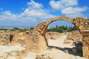
Inside the Paphos Archaeological Park, just north of the old harbor, a pile of broken stones and toppled columns marks where one of Cyprus's most important medieval fortresses once stood. Saranta Kolones, which translates to Forty Columns, served as the main defensive stronghold protecting Paphos during a turbulent period when Arab raids threatened the island. Today, visitors walk among its ruins and discover a fortress that endured multiple rebuilds, witnessed crucial historical events, and met a violent end in one of the worst earthquakes ever to strike Cyprus. tripadvisor-com Historical Background The fortress was built at the end of the 7th century AD under Byzantine rule. Historical records indicate that Theodore, the brother of Emperor Heraclius I, supervised its construction. At that time, the Arab Caliphate had emerged as a powerful force in the Middle East, and Cyprus found itself in the path of expansion. Arab forces launched raids on the island, making coastal cities particularly vulnerable. Paphos, with its strategic harbor and position on shipping routes, needed strong defenses. hotel-com The Byzantine builders created a formidable structure. The fortress featured walls three meters thick, substantial enough to resist siege weapons of that era. Four massive corner towers anchored the defenses, with four additional intermediate towers positioned along the connecting walls. A moat surrounded the entire complex, and access was…

Read more
Arabahmet Mosque (Nicosia)

Arabahmet Mosque (Nicosia)

Arabahmet Mosque is a 16th-century Ottoman mosque located in the Arab Ahmet Quarter of Nicosia. Built in the late 1500s shortly after the Ottoman conquest of Cyprus in 1571, the mosque was named after Arab Ahmet Pasha, one of the commanders who led the Ottoman army during the invasion. He also served as Governor General of Rhodes. shutterstock-com The mosque is the only one in Cyprus to feature typical Turkish-style domes. A large central dome about 6 meters across covers the main prayer hall, three smaller domes protect the entrance porch, and four more tiny domes sit at the building's corners. This design follows the classical Anatolian style of placing a dome on a square building. Historical Background Arab Ahmet Pasha was a senior military officer in the Ottoman forces that conquered Cyprus. After the successful invasion, the neighborhood where his mosque stands became one of the most important residential areas in Ottoman Nicosia. High-ranking Turkish officials, judges (kadis), and governors (pashas) chose to live here for two practical reasons. severis-org First, the area was close to the old Ottoman Saray, which had been the Lusignan Palace before the conquest. Officials could walk to work easily. Second, Arab Ahmet Quarter caught the evening breeze coming from Morphou Bay in the west, making the coolest part of the city during hot…

Read more
Cape Aspro Reserve

Cape Aspro Reserve

Cape Aspro is located on the southern coast of Cyprus between Limassol and Paphos. The name translates to "white" in Greek, a fitting description for the dramatic limestone cliffs that tower over 200 meters above the turquoise Mediterranean Sea. This natural reserve offers visitors a unique combination of geological wonder, biological diversity, and outdoor adventure. pissouriana-com The white cliffs of Cape Aspro formed over millions of years through natural geological processes. Composed of sedimentary limestone, these formations emerged as wind and sea erosion sculpted the coastline into its current dramatic shape. The cliffs feature caves, arches, and steep edges that create stunning visual contrasts, especially during sunrise and sunset when light reflects off the pale limestone surfaces. These geological formations connect to Cyprus's broader Troodos Ophiolite complex, a rare example where ancient oceanic crust and mantle rock were uplifted through tectonic activity approximately 90 million years ago. Today, visitors can see rocks that once existed more than 20 kilometers below the ocean floor, now exposed and accessible along the coastal trails. Network of Trails Leads to Panoramic Views The reserve features seven interconnected color-coded trails, with routes ranging from 3.5 kilometers to 12.3 kilometers in total distance. These paths wind along cliff edges and through the rugged coastal terrain, with the longest trail reaching approximately 10 kilometers when including the…

Read more