Explore Cyprus with Our Interactive Map

Explore our top stories and discover ideas worth your time.

Ariadni Nature Trail

Ariadni Nature Trail

The Troodos Mountains host a remarkable path known as the Ariadni Nature Trail. This route offers a direct look into the heart of the forest. Nature enthusiasts travel here for the calm atmosphere. The air stays cool even in the heat of the summer months. It serves as a sanctuary for many local plants. The terrain consists of diverse rock formations and dense tree cover. Hikers find a sense of peace among the tall pines. Each step reveals a new view of the deep valleys below. The site remains a top choice for those who seek quiet beauty. It provides a unique window into the island’s wild interior. This journey starts near the village of Gerakies and winds through the woods. The path is clear and easy to follow for most visitors. It connects several points of interest within the state forest. People admire the craft of the old stone walls along the way. This trail stands as a testament to the natural wealth of the region. Trail Overview Location: Gerakies Village Troodos Mountains Distance: 3.1 miles (5 km) Route Type: Point to Point Difficulty: Moderate Elevation Gain: 650 feet (200 meters) Duration: 2 to 2.5 hours Best Time to Visit: April to June or September to November Terrain: Forest Floor and Rocky Slopes Geological Context The Ariadni Nature Trail…

Read more
Cyprus Green Line Today

Cyprus Green Line Today

The Green Line takes its name from a green chinagraph pencil used by British Major General Peter Young on December 30, 1963. He drew a ceasefire line on a map of Nicosia during a twelve-hour meeting following intercommunal violence between Greek and Turkish Cypriots. That pencil mark became the basis for one of Europe's most visible political divisions. Today the Green Line stretches 180 kilometers from Kato Pyrgos in the west to Paralimni in the east, cutting across the entire island. It varies from just 3.3 meters wide in central Nicosia to 7.4 kilometers wide in rural areas. The buffer zone covers 346 square kilometers, roughly 3.7 percent of Cyprus's total land area. After the Berlin Wall fell in 1989, Nicosia became the last divided capital city in the world, a distinction it still holds. From Pencil Line to Military Frontier The original 1963 Green Line addressed only Nicosia and remained relatively informal. The 1974 Turkish invasion changed everything permanently. Following a coup attempt by Greek Cypriot nationalists seeking union with Greece, Turkey intervened militarily and captured approximately 37 percent of the island. The ceasefire of August 16, 1974, froze the front lines in place. These lines became the boundaries of the current buffer zone, with the Turkish army holding the north and the Republic of Cyprus controlling the south.…

Read more
Roman Cyprus: Mediterranean Maritime Hub

Roman Cyprus: Mediterranean Maritime Hub

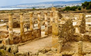
When Cyprus became part of the Roman world, the island did not need to reinvent its relationship with the sea. Instead, Rome refined it. Over centuries, Roman engineers, administrators, and merchants transformed Cyprus into a carefully managed maritime province, one that linked eastern trade routes with the wider Mediterranean through ports, harbors, and logistics designed for permanence rather than improvisation. From Crossroads to System Cyprus had always sat between worlds. Long before Roman rule, ships traveling between the Levant, Egypt, Asia Minor, and the Aegean passed its shores. What changed under Rome was not geography, but organization. The Romans treated the sea as infrastructure. Ports were no longer just safe places to land. They became regulated environments, engineered to control movement, store goods, and support long-distance trade at scale. Cyprus, stable and centrally located, was perfectly suited to this vision. Engineering the Coastline Roman maritime power rested on the belief that nature could be improved. Where earlier cultures relied heavily on natural bays, Roman builders reshaped coastlines to suit imperial needs. Artificial breakwaters extended into open water. Quays were reinforced to handle heavy cargo. Harbors were designed to remain functional across seasons, not only during calm months. These were not short-term solutions. Roman ports were built to last for generations. On Cyprus, this approach created a hierarchy of ports, each…

Read more