Explore Cyprus with Our Interactive Map

Explore our top stories and discover ideas worth your time.

Traditional Cypriot Dances Spoke Without Words

Traditional Cypriot Dances Spoke Without Words

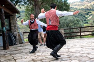
Long before dating, private meetings, or casual conversation between young men and women were socially acceptable, Cyprus had another system. It happened in village squares (Omodos Village Square), at weddings, and during festivals. It used rhythm instead of language and movement instead of promises. Through paired dances such as the Sousta and Antikristos, Cypriot communities created a public, structured way for courtship to unfold, allowing interest, character, and respect to be displayed openly while remaining within strict social boundaries. These dances were never casual entertainment. They were carefully coded social encounters, understood by everyone watching. Face to Face, but Never Too Close At the heart of Cypriot courtship dancing is a simple idea: two people facing one another. The Antikristos, whose name literally means “opposite” or “face to face,” places dancers across from each other rather than in a circle or line. This positioning mattered. It allowed eye contact, acknowledgement, and interaction, but always at a controlled distance. pinterest.com2 In traditional village life, direct interaction between unmarried men and women was limited. The dance floor became one of the few socially accepted spaces where such interaction could occur in public, under the gaze of the community. Nothing was hidden. Everything was observed. The Sousta follows a similar logic but adds energy. Its springing, hopping steps introduce vitality and momentum, turning…

Read more
Alampra Bronze Age Copper Town

Alampra Bronze Age Copper Town

Alampra Mouttes stands as one of Cyprus’s most significant Middle Bronze Age settlements. Located in central Cyprus near the modern village of Alampra, this archaeological site provides rare evidence of prehistoric urban life and early copper metallurgy between 1900 and 1650 BC. The excavated remains reveal a substantial community that occupied a strategic position close to copper ore deposits at the foothills of the Troodos Mountains. Wikipedia-com The archaeological site occupies the northeast facing flank of a ridge between two hills called Mouttes and Spileos. The settlement consists of multi room rectangular houses built from local limestone and flint, with walls still standing in several areas. During its period of occupation, Alampra functioned as a largely self sufficient agricultural and metallurgical community. The site lies about 8 kilometers east of Marki Alonia, another major Bronze Age settlement, and sits at the point where the volcanic pillow lava foothills of the Troodos Massif meet the calcareous limestone of the central Mesaoria plain. Historical Background Archaeological interest in Alampra began in the 19th century, but the first systematic investigation took place in 1924 when Swedish archaeologist Einar Gjerstad excavated a prehistoric house he named Mavroyi, meaning red earth. For decades, this remained the only precisely documented building in Cyprus from the long period between the Chalcolithic and the end of the Middle…

Read more
Buffavento Castle Cyprus

Buffavento Castle Cyprus

Buffavento Castle stands at 960 meters above sea level in the Kyrenia mountain range of Cyprus. This medieval fortress is the highest and least preserved of three Byzantine strongholds built along the mountains. The name comes from Italian and means "Defier of the Winds," a fitting description for a castle constantly exposed to mountain winds at this elevation. cycprusfaqs-com The castle sits between St. Hilarion Castle to the west and Kantara Castle to the east, forming a defensive line across the Kyrenia Mountains. All three castles are visible from each other, allowing them to pass signals and warnings. Buffavento guarded the mountain passage from Kythrea to the north coast, controlling movement between the coastal plain and the interior. The location provides views in every direction. Looking north across the Mediterranean Sea, visitors can see the Turkish coast approximately 65 kilometers away on clear days. To the south, the Mesaoria Plain stretches toward Nicosia. On exceptionally clear days, Famagusta to the east and the Troodos Mountains to the south are visible. The castle overlooks nearly half the island from its rocky peak. The steep cliffs surrounding the fortress made it naturally defensible. The north, east, and west sides are protected by sheer drops, with only the southern approach allowing access. Historical Background The exact construction date remains unknown, though most historians…

Read more