Explore Cyprus with Our Interactive Map

Explore our top stories and discover ideas worth your time.

Semi-Arid Inland Plains Climate (Mesaoria)

Semi-Arid Inland Plains Climate (Mesaoria)

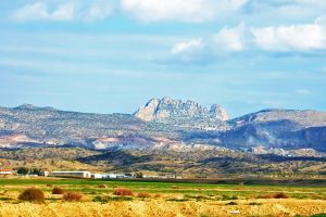
Semi-Arid Inland Plains Climate (Mesaoria) is characterized by low rainfall and hot summers, a pattern that has shaped Cyprus's central lowlands with drought-resistant vegetation and adapted agricultural practices. This climate, with annual precipitation under 350mm and temperatures soaring above 40°C in July-August, creates a landscape of dry riverbeds, thorny shrubs, and resilient crops like barley. It influences everything from biodiversity to human settlement, highlighting how the island's interior has fostered unique ecosystems and cultural responses to aridity. A Harsh Yet Resilient Inland Environment The Mesaoria Plains, often called the "breadbasket" of Cyprus, span the island's central region between the Troodos and Kyrenia Mountains, covering approximately 2,500 square kilometers. This semi-arid zone experiences extreme seasonal contrasts, where scorching summers give way to mild winters with sporadic rains. Low rainfall, averaging 300-400mm annually, concentrates in short winter bursts, leading to high evaporation rates that deplete soil moisture and create a challenging environment for life. Hot summers, with daytime highs frequently exceeding 35°C and occasional peaks at 45°C, intensify water scarcity, promoting vegetation that conserves resources through deep roots and reduced leaf surfaces. fergusmurraysculpture.com This climate has molded a resilient ecosystem, where plants like the thorny burnet (Sarcopoterium spinosum) and wild thyme dominate, forming maquis scrublands that prevent soil erosion on the plains' calcareous soils. Agriculture adapts with drought-tolerant crops such as carob…

Read more
Cape Aspro Reserve

Cape Aspro Reserve

Cape Aspro is located on the southern coast of Cyprus between Limassol and Paphos. The name translates to "white" in Greek, a fitting description for the dramatic limestone cliffs that tower over 200 meters above the turquoise Mediterranean Sea. This natural reserve offers visitors a unique combination of geological wonder, biological diversity, and outdoor adventure. pissouriana-com The white cliffs of Cape Aspro formed over millions of years through natural geological processes. Composed of sedimentary limestone, these formations emerged as wind and sea erosion sculpted the coastline into its current dramatic shape. The cliffs feature caves, arches, and steep edges that create stunning visual contrasts, especially during sunrise and sunset when light reflects off the pale limestone surfaces. These geological formations connect to Cyprus's broader Troodos Ophiolite complex, a rare example where ancient oceanic crust and mantle rock were uplifted through tectonic activity approximately 90 million years ago. Today, visitors can see rocks that once existed more than 20 kilometers below the ocean floor, now exposed and accessible along the coastal trails. Network of Trails Leads to Panoramic Views The reserve features seven interconnected color-coded trails, with routes ranging from 3.5 kilometers to 12.3 kilometers in total distance. These paths wind along cliff edges and through the rugged coastal terrain, with the longest trail reaching approximately 10 kilometers when including the…

Read more
Lapithos

Lapithos

Lapithos sits on the northern coast of Cyprus beneath the Kyrenia mountains, where lemon groves once produced 11 million fruits per year and Byzantine treasures buried during Arab raids emerged a thousand years later in museum collections around the world. This settlement has existed for over 5,000 years under at least four different names. adobe-stock-com Lapithos is one of the oldest continuously inhabited sites on Cyprus. The modern town of Lapithos occupies the slopes of the Pentadactylos mountain range near where the ancient city kingdom once stood. The coastal ruins three kilometers north are called Lambousa, the name used during Roman and Byzantine times. Ancient writers, including Strabo, knew it as Lapethos. The philosopher Alexander of Ephesus called it Imeroessa, meaning attractive and passion-arousing. Assyrian inscriptions from 700 BC mention it as Sillu. Each name reflects a different period in the settlement's long history. Historical Background The oldest settlement at Lapithos dates to the Neolithic or Chalcolithic period and is located west of the current town at a site called Alonia ton Plakon. Archaeological evidence, including pottery and pottery wheels, confirms occupation as early as 3000 BC. Stone foundation walls, hearths, and three bothroi cut into rock have been found, though floods and later cultivation damaged much of the early settlement. adobe-stock-com According to Greek tradition, Spartan colonists led by…

Read more