The Agios Onoufrios nature trail offers a profound look into the rugged beauty of the Machairas forest. This path winds through a landscape rich with history and diverse plant life. It provides a quiet space for those who want to see the wild side of the island.
The route starts near the historic monastery and climbs toward the high ridges. Each step reveal a new part of the valley below. The air stay cool even in the heat of the summer months. This trek is a favorite for people who appreciate silence and natural views.
The path is well mark and easy to follow for most hikers. It showcases the unique geology of the Troodos foothills. Visitors can see the impact of ancient volcanic activity in the rocks. This journey connects the soul to the ancient earth of Cyprus.
Trail Overview
- Location: Machairas Forest, Nicosia District, Cyprus
- Distance: 5.2 miles (8.4 km)
- Route Type: Circular
- Difficulty: Moderate
- Elevation Gain: 1148 feet (350 meters)
- Duration: 3 – 3.5 hours
- Best Time to Visit: October–May
- Terrain: Rocky and Dirt Path
Geological Foundation and Soil Composition
The foundation of the Agios Onoufrios trail consists of diabase and gabbro rocks. These stones belong to the Troodos ophiolite complex which is a world famous geological site. This area once sat at the bottom of a deep sea millions of years ago. Tectonic forces pushed the ocean floor high into the air to form the island. The soil that results from these rocks is thin and full of minerals. This specific earth supports the growth of endemic plants that live nowhere else.
The color of the ground shift from deep red to dark grey as the path ascends. Iron and magnesium within the rocks create these distinct shades. Water erosion over centuries has carved deep gullies into the mountain side. These channels direct the winter rain down to the Pedieos river. The solid rock layers act as a natural filter for the groundwater. This process ensures that the local springs stay clean and full of minerals. Hikers can observe these rock layers in the steep cuts along the trail.
Flora of the Machairas Forest
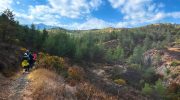
The vegetation along the route is a mix of hardy shrubs and tall pine trees. Calabrian pines dominate the upper canopy and provide much needed shade. These trees can survive in dry conditions and poor soil. Beneath the pines grow the golden oaks which are a symbol of the Cyprus mountains. The leaves of these oaks have a yellow underside that glimmers in the sun. This tree is a protected species because it is endemic to the island.

The forest floor is home to various types of rockrose and thyme. These plants release a strong scent when the sun warm the ground. In the spring months wild orchids and cyclamens appear in the shadows. These flowers add a splash of color to the green and brown landscape. The botanical diversity here is a result of the altitude and the moisture from the sea. Each plant plays a role in the local food web. They provide nectar for bees and shelter for small forest creatures.
Wildlife and Avian Observations
The quiet nature of the trail make it a perfect spot for bird watching. Raptors like the Bonelli eagle often soar on the thermal currents above the ridges. These large birds hunt for small mammals across the open slopes. The Cyprus warbler hide in the dense bushes and sing during the dawn hours. This bird is a resident species that stay on the island all year. Wood pigeons also nest in the high branches of the pine trees.

Lizards are common sights on the rocks during the warmer hours of the day. They bask in the sun to regulate their body heat before they hunt for insects. Snakes live in the area but they usually avoid the main path. The Cyprus mouflon is more rare but it occasionally visit the lower forest. These wild sheep are very shy and run away at the first sound of a human. The presence of these animals indicates a healthy and balanced ecosystem. All species within the Machairas forest enjoy legal protection to ensure their survival.
Historical and Cultural Context
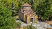
The name of the trail come from the saint who lived a life of solitude. The nearby Machairas Monastery is one of the most sacred sites in Cyprus. It was found in the twelfth century and holds a famous icon of the Virgin Mary. The history of the monastery is link to the struggle for independence. Many monks and locals used these mountain paths to hide from invaders. The ruins of old stone huts can still be found near the trail.
These structures once served as shelters for shepherds and charcoal makers. People in the past relied on the forest for their daily survival. They gathered wood for heat and herbs for medicine from these slopes. The trail follow some of the same routes that these people used for centuries. This connection to the past adds a layer of depth to the walk. It is a reminder of how humans and nature have coexisted on the island. The silence of the trail today is a contrast to the busy life of the past.
Atmospheric Conditions and Seasonal Change
The climate in the Machairas region is milder than the hot central plains. In the winter snow can cover the peaks and turn the forest white. This change create a dramatic scene as the green pines peek through the frost. The melt water in the spring fill the streams and create small waterfalls. This is the best time to see the forest at its most vibrant. The air is crisp and the visibility is excellent for miles.
Autumn bring a shift in the color of the deciduous trees like the wild pear. The temperatures drop to a comfortable level for long distance walking. Summer is the most difficult time because the sun is very strong. Hikers must start their journey at dawn to avoid the midday heat. The shade of the pines offer some relief but water is a top priority. Each season offer a different perspective on the beauty of the trail. The landscape never stay the same for more than a few months.
Navigation and Safety Guidelines
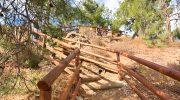
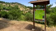
The Agios Onoufrios trail is part of a large network of paths in the forest. Clear wooden signs provide the direction at every major junction. It is vital to stay on the mark route to protect the fragile soil. The path can be steep in certain sections so sturdy boots are a must. Loose stones can make the descent a bit slippery after a rain shower. A walking stick can provide extra balance on the rocky slopes.
Safety also involve a respect for the local environment. Fires are strictly forbidden due to the risk of forest blazes. Hikers should carry out all their trash to keep the forest clean. It is a good idea to check the weather forecast before you leave. Sudden storms can move in fast over the Troodos range. Always tell someone your plan and the time you expect to return. These simple steps ensure a safe and enjoyable experience for everyone.


