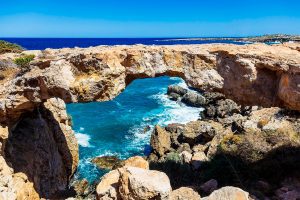
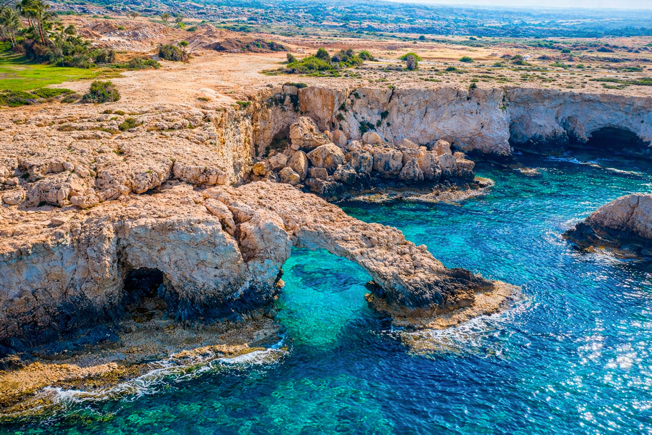
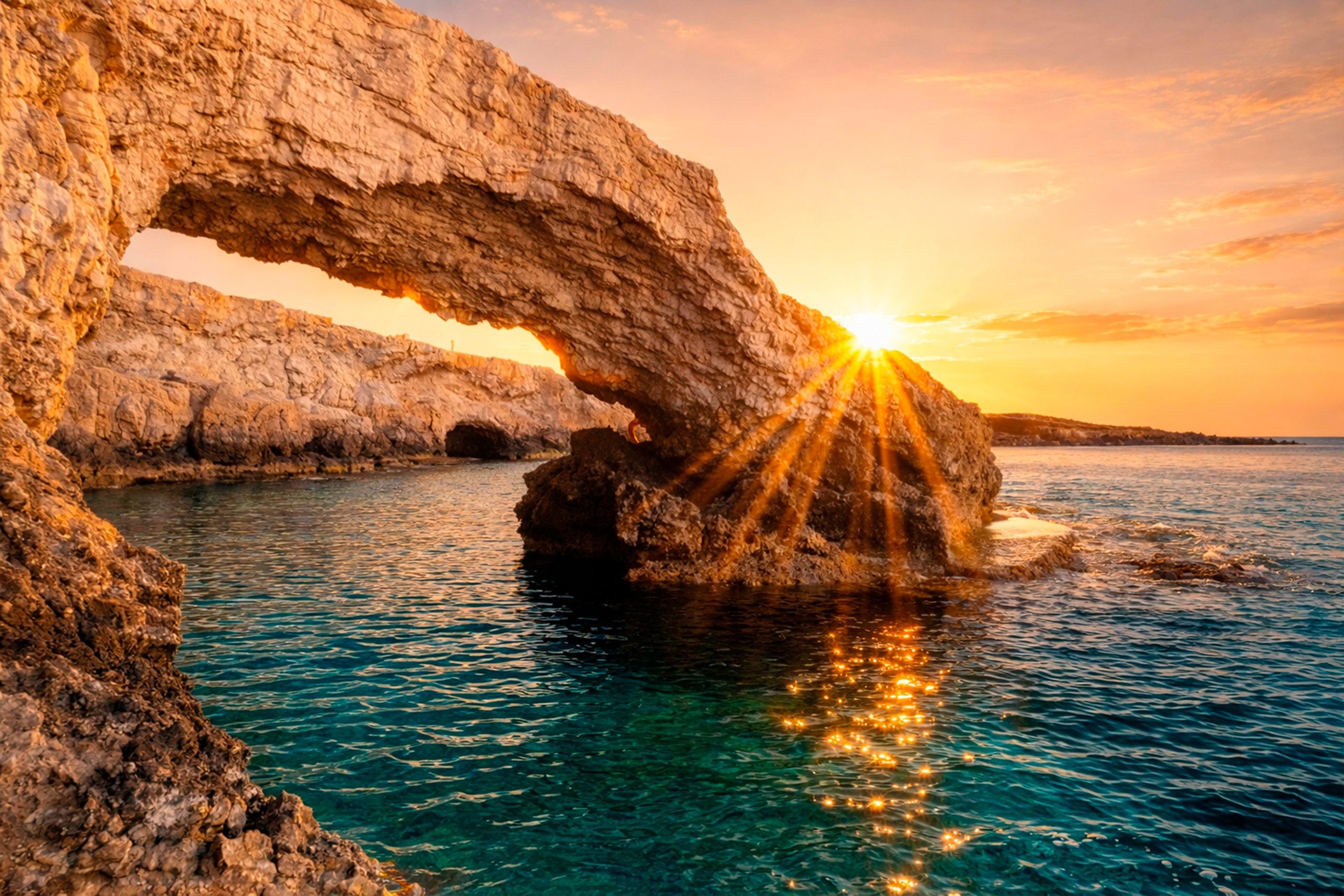
The Lover’s Bridge stands as one of Cyprus’s most photographed natural landmarks. This limestone arch extends from the coastal cliffs near Ayia Napa, reaching toward the Mediterranean Sea with one end firmly anchored to land while the other dips into crystal-clear turquoise water.
The bridge measures approximately 6 meters long and half a meter wide, formed entirely through natural processes without any human construction. Visitors from around the world come to walk across this slender natural formation, particularly during sunset hours when golden light transforms the white limestone and azure water into a scene of remarkable beauty.
The bridge takes its name from romantic traditions that have developed around the site. Local legend claims that couples who kiss while standing in the middle of the arch and make a wish together will see their wishes come true. This belief has made the location a popular destination for marriage proposals, wedding photographs, and symbolic ceremonies celebrating love and commitment.
How Wave Action Sculpted the Arch
The Lover’s Bridge formed through a combination of mechanical and chemical erosion acting on limestone bedrock. Rainwater absorbs carbon dioxide from the atmosphere and soil, creating a weak carbonic acid solution. When this slightly acidic water contacts limestone, it triggers chemical reactions that gradually dissolve the calcium carbonate rock.
Seawater contains additional dissolved salts and compounds that enhance erosion rates, particularly in the splash zone where waves repeatedly wet and dry the rock surface. Over thousands of years, wave action concentrated force on weaknesses in the cliff face, including existing fractures and zones where the rock was less dense or more porous. Water pressure from waves forced into cracks gradually widened these openings.
Biological processes also contributed to erosion. Marine organisms including barnacles, mollusks, and algae attach to rock surfaces in the intertidal zone and physically or chemically break down the limestone. This bioerosion creates pits, grooves, and channels that accelerate mechanical weathering.
The arch reached its current form through continued erosion that hollowed out a passage through the rock while leaving the upper portions intact as a natural bridge. The structure remains stable because the arch shape distributes stress effectively, though ongoing erosion continues to modify the formation gradually.
The Limestone Cliffs and Coastal Geology
Cape Greco’s limestone formations date to the Miocene and Pliocene epochs, roughly 5 to 7 million years ago when this area sat beneath a shallow sea. Calcium carbonate from marine organisms accumulated on the seafloor, eventually compacting into limestone beds. Tectonic forces later lifted these ancient seabed deposits above current sea level, exposing them to weathering.
The limestone cliffs reach heights of approximately 30 feet in places, with the Lover’s Bridge positioned at a moderate elevation above the water. The rock displays characteristic light tan to white coloring, with horizontal bedding planes visible in many sections. Fractures and joints create natural lines of weakness that control where erosion proceeds most rapidly. The coastline exhibits numerous other karst features beyond the main arch.
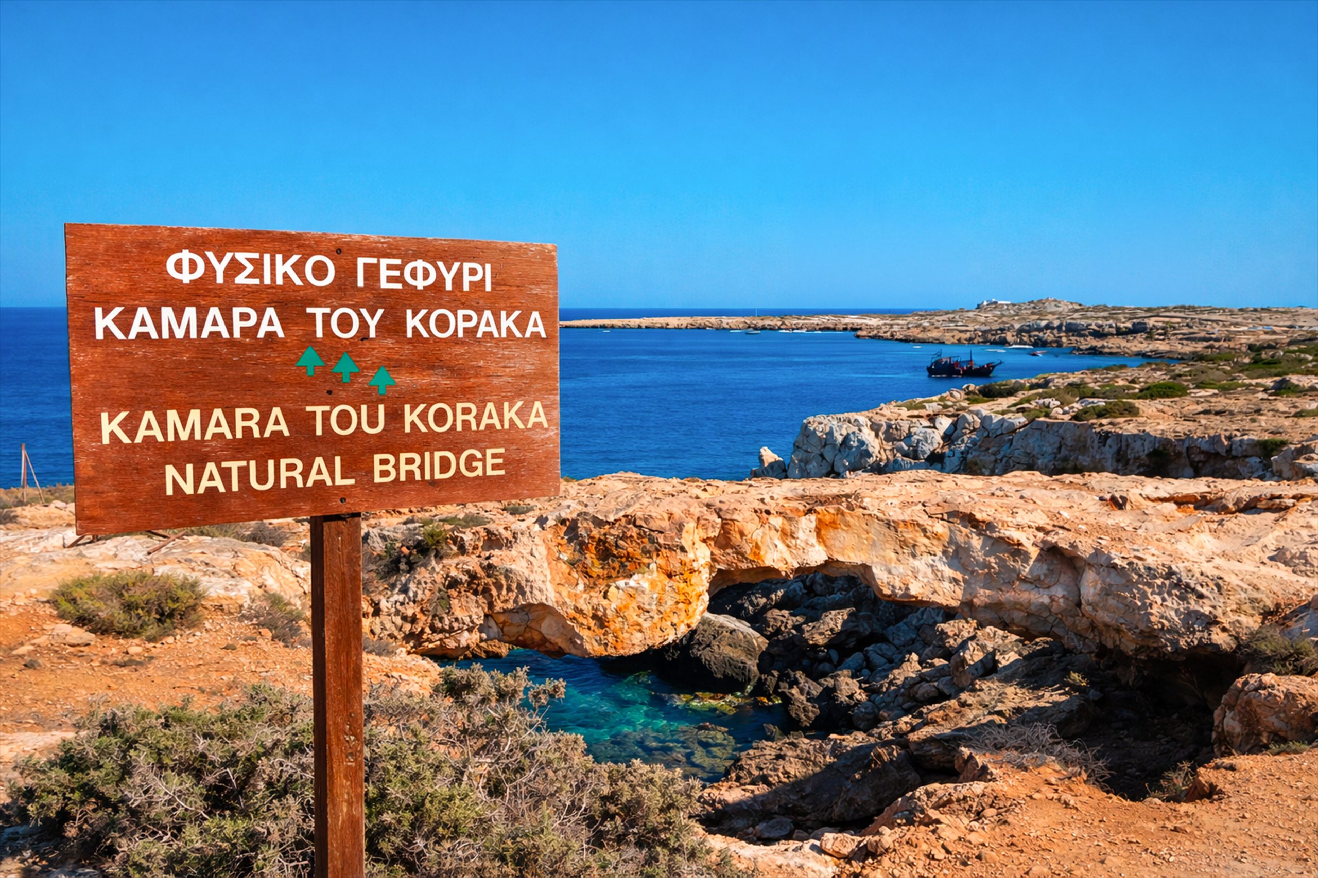
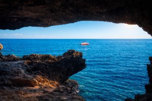
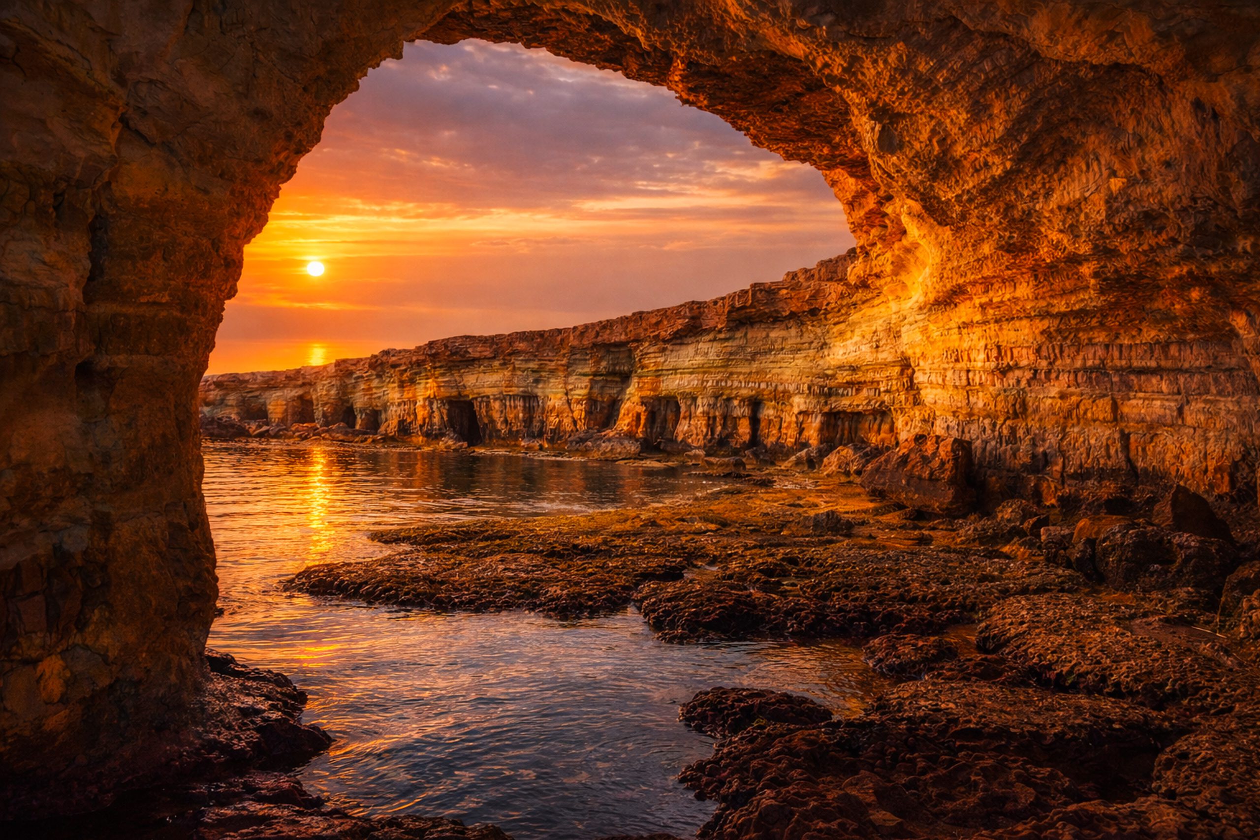
Sea caves extend up to 80 meters into the cliffs in some locations, accessible by swimming during calm conditions. Natural tunnels connect certain caves, allowing adventurous swimmers to pass through the rock. Several smaller arches punctuate the coastline, including Kamara tou Koraka located elsewhere in Cape Greco with different proportions and orientation.
Marine Life in Crystal Clear Waters
The waters surrounding the Lover’s Bridge support diverse Mediterranean marine ecosystems. Water visibility often exceeds 30 meters, allowing clear views of underwater rock formations and marine organisms. The limestone provides substrate for numerous attached species. Algae coat many submerged surfaces, forming the base of local food webs. Sea urchins graze on these algae, their spines visible among rock crevices.
Various fish species inhabit the area, from small colorful wrasses to larger groupers that shelter in caves and under overhangs. Schools of damselfish and bream move through the water column, while octopuses hide in rocky dens during daytime. Snorkelers and divers regularly observe this marine life around the arch and nearby caves.

The clear water and relatively shallow depths make the location accessible to beginners while still offering interest for experienced divers. Water temperatures range from 16 degrees Celsius in winter to 28 degrees Celsius during summer months, with the warmest period from June through October providing the most comfortable conditions for extended water activities.
Local Traditions and Romantic Symbolism
The bridge gained its romantic associations relatively recently as tourism developed in Ayia Napa. The belief that kissing on the arch brings wishes to fruition mirrors similar traditions at romantic landmarks worldwide. Many couples attach padlocks to nearby fences and railings as tokens of their relationship, a practice borrowed from bridges in Paris and other cities.
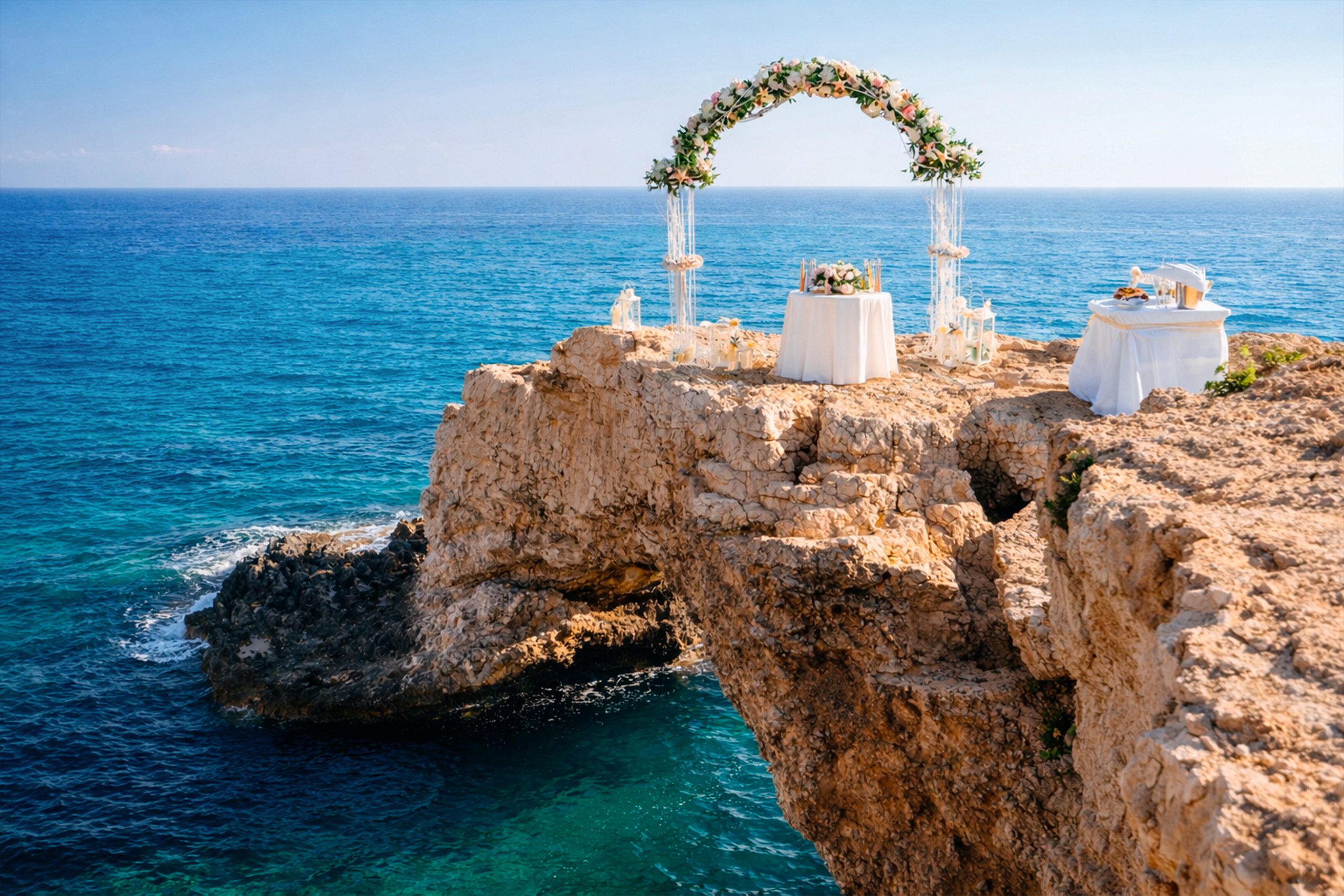
Wedding photographers frequently use the location for couple portraits, taking advantage of the dramatic natural backdrop and symbolic meaning. Some couples schedule entire wedding ceremonies or vow renewals at the site, though the narrow arch limits the number of people who can safely stand on it simultaneously.
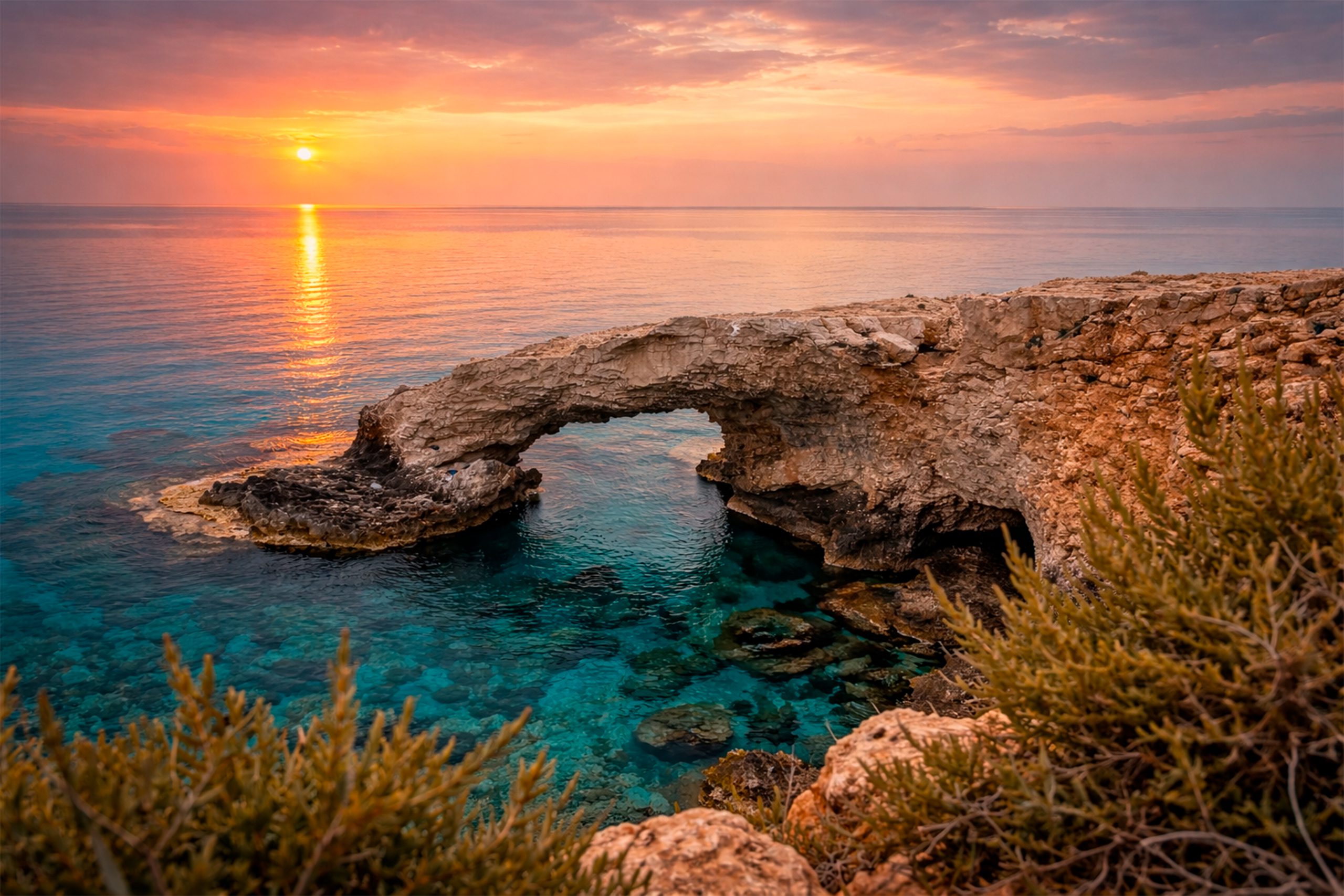
The heart-shaped gap visible between the arch and water’s surface in certain viewing angles reinforces the romantic imagery. Photographers time visits to capture this perspective, particularly during golden hour when low sun angles create warm tones and long shadows.
Why This Natural Arch Matters Today
The Lover’s Bridge demonstrates the ongoing geological processes that shape Mediterranean coastlines. The formation provides a tangible example of karst landscape development for educational purposes, helping students and visitors understand how chemical weathering operates on limestone over long time scales.
As part of Cape Greco National Forest Park, the arch receives protection from development and destructive activities. Management guidelines aim to balance public access with conservation needs.

The popularity of the site generates tourism revenue for the Ayia Napa region while raising awareness about natural heritage preservation. The bridge’s accessibility makes it suitable for visitors of varying ages and fitness levels. Unlike remote natural attractions that require extensive hiking or specialized equipment, this formation sits close to parking areas and can be reached via a short walk.
However, the slippery rock surface when wet and the narrow width of the arch itself present safety considerations. Visitors who choose to walk onto the formation must exercise caution, and local authorities have discussed whether to implement restrictions during peak tourist periods to prevent accidents.
Visiting the Bridge and Surrounding Area
The Lover’s Bridge sits approximately 2 kilometers east of central Ayia Napa along the coastal road toward Cape Greco. Parking lots provide space for personal vehicles, though these fill quickly during summer months and weekends. The closest lot sits about 100 meters from the arch, requiring only a short walk across relatively flat terrain.
Public buses on routes 101 and 102 between Ayia Napa and Protaras stop at nearby locations including Marina stop, placing visitors within a few minutes’ walk of the site.
Many visitors combine a bridge visit with exploration of other Cape Greco attractions. The Ayioi Anargyroi Chapel perches on cliffs nearby, offering coastal views and historical interest. Sea caves extend along the coastline in both directions, accessible by foot along clifftop paths or by swimming for those comfortable in open water.
Boat tours departing from Ayia Napa marina regularly include the Lover’s Bridge on their routes, providing views from sea level and opportunities to swim near the formation. These excursions typically last 2 to 4 hours and visit multiple coastal features.
Sunset represents the most popular time for photography, with warm light illuminating the white limestone and creating reflections on the water. However, this timing also brings the largest crowds. Sunrise visits offer similar lighting conditions with fewer people present.
Midday sun creates harsh contrasts and shadows that some photographers find less appealing, though the bright conditions showcase the water’s clarity and turquoise color.
Walking onto the arch itself remains legal but requires careful foot placement. The limestone surface becomes extremely slippery when wet from waves or morning dew. Sturdy footwear with good traction helps prevent falls. Strong winds can create balance challenges on the narrow formation.
A Natural Monument to Geological Time
The Lover’s Bridge preserves evidence of the slow but relentless forces that shape coastal landscapes throughout the Mediterranean region. The formation connects modern visitors to geological processes operating over timescales far beyond human lifespans, demonstrating how patient natural forces can create structures of beauty and interest.
The arch’s popularity reflects human appreciation for natural formations that combine aesthetic appeal with symbolic meaning. While the romantic traditions surrounding the bridge developed recently, they add cultural layers to the geological significance.
As Cyprus continues developing its tourism economy, sites like the Lover’s Bridge demonstrate the value of protecting natural landmarks.
The formation attracts visitors who contribute to local businesses while experiencing a free, accessible natural wonder. The balance between preservation and access remains important as visitation numbers grow and climate change potentially alters erosion rates and sea levels that could affect the bridge’s long-term stability.