Cyprus did not become influential in the ancient Mediterranean by expanding inland or building empires on land. Its power grew from the edge of the sea. During the Bronze Age, natural harbors along the Cypriot coast evolved into gateways that connected the island to distant worlds.
These maritime entry points shaped cities, concentrated wealth, and transformed Cyprus from a resource-rich island into a central player in early Mediterranean exchange. To understand Bronze Age Cyprus, it is necessary to look not at walls or palaces first, but at the waterlines where ships arrived.
- Where Land Met Opportunity
- A Coastline Designed for Exchange
- From Fishing Villages to Maritime Cities
- Cities Shaped by Their Harbors
- What a Bronze Age Harbor Looked Like
- Trade That Built Power
- Life Along the Waterfront
- Small Details That Tell a Larger Story
- A Coastal Identity Takes Form
- Echoes Along the Modern Coast
- Why These Harbors Still Matter
Where Land Met Opportunity
Bronze Age harbors were not abstract ideas or convenient backdrops. They were the practical foundations of coastal life. In Cyprus, sheltered bays, shallow inlets, and calm lagoons allowed early ships to anchor safely, beach their hulls, and unload heavy cargo. These locations quickly attracted people. What began as seasonal landing points became permanent settlements built around maritime access.
Harbors created opportunity. Inland communities focused on farming and mining, but coastal settlements gained something more powerful. They gained connection. Through the sea came materials, skills, and ideas that reshaped how people lived and governed. Over time, the harbor was no longer just part of the city. It became its reason for existence.
A Coastline Designed for Exchange
Cyprus was unusually well positioned for Bronze Age seafaring. The island sits between three major cultural zones: the Aegean, the Levant, and Egypt. Ships traveling between these regions naturally passed close to its shores. Even with early sailing technology, distances were manageable and routes predictable during favorable seasons.
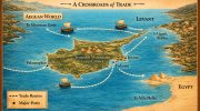
The coastline itself encouraged harbor development. Rocky headlands provided shelter from prevailing winds. Shallow waters allowed ships to remain close to land. Freshwater sources near the coast supported growing populations. Just inland, the Troodos Mountains offered copper in quantities unmatched elsewhere in the region.
This combination was rare. Cyprus could extract a valuable resource, move it efficiently to the coast, and ship it outward with relative ease. Geography did not merely help maritime trade. It structured it.
From Fishing Villages to Maritime Cities
Early coastal settlements were modest, often tied to fishing or small-scale exchange. The turning point came as demand for copper increased across the Mediterranean. Bronze tools and weapons became essential, and societies required steady access to metal.

As copper production expanded, certain coastal sites grew rapidly. Some evolved organically from earlier villages. Others appear to have been deliberately established near good anchorages to manage refining, storage, and export. The exact degree of centralized control remains debated among scholars. Some evidence suggests coordinated administration, while other interpretations point to powerful regional centers operating independently.
What is clear is that harbors became the focal points of economic and political life. Control of maritime access meant control of trade. Cities with effective harbors gained influence far beyond their size.
Cities Shaped by Their Harbors
Several Bronze Age coastal settlements illustrate how harbors shaped urban development in Cyprus.

Enkomi Situated near a navigable inlet on the east coast, Enkomi became one of the island’s most important trade centers. Its access to sea routes connecting the Levant and Egypt allowed it to flourish as a hub of exchange and copper export.

Kition Built beside a natural lagoon, Kition combined harbor activity with large-scale copper processing. Its waterfront supported workshops, storage areas, and religious spaces tied to maritime life, reflecting the close link between trade and belief.

Hala Sultan Tekke Now overlooking a salt lake, this site was once a thriving port. During the Late Bronze Age, it ranked among the wealthiest coastal settlements on the island. Environmental change has since reshaped the landscape, but its former maritime role remains clear.
Maa-Palaeokastro Located on a rocky promontory along the western coast, Maa-Palaeokastro served as a strategic entry point for ships arriving from the Aegean. Its position allowed both shelter and oversight, combining defense with access. Each of these cities grew differently, yet all were shaped by their relationship to the sea.
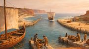
What a Bronze Age Harbor Looked Like
Most Cypriot harbors began as natural anchorages rather than fully engineered ports. Ships were often pulled onto beaches or anchored just offshore. Over time, simple modifications improved functionality.
Stone quays, low breakwaters, and leveled landing areas helped calm waters and define docking zones. Storage facilities stood close to the shore, including large jars for oil, grain, and goods awaiting shipment. Copper workshops were often nearby, minimizing the effort required to move heavy ingots.
Cities developed planned layouts that reflected this maritime focus. Streets led directly to the waterfront. Residential, industrial, and administrative zones were organized around access to the harbor. Elite residences frequently overlooked the sea, allowing leaders to monitor arrivals and control exchange. The harbor was not separate from urban life. It organized it.
Trade That Built Power
Copper dominated exports, shipped in standardized oxhide-shaped ingots that could be stacked and secured aboard vessels. Timber, agricultural products, and crafted items also left Cypriot ports.
In return came goods that Cyprus could not produce itself. Fine ceramics from the Aegean, luxury items from Egypt, and tin from eastern regions all entered through the same gateways. Every ship brought material wealth and cultural influence.
Managing this flow created power. Those who controlled harbor access shaped local politics, accumulated resources, and negotiated with foreign traders. Over time, harbor-centered cities became the nuclei of early Cypriot kingdoms.
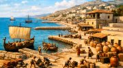
Life Along the Waterfront
Harbors were the most active spaces in Bronze Age cities. They were loud, crowded, and constantly changing. Sailors repaired ships. Laborers moved cargo. Traders negotiated in multiple languages. The shoreline was a place of work, risk, and opportunity.
Daily life followed the sailing season. Spring through autumn brought activity and wealth. Winter slowed movement and shifted attention to manufacturing and preparation. Foreign merchants often stayed for extended periods, blending into local communities and influencing customs, cuisine, and artistic styles.
The harbor exposed Cyprus to the wider world, not occasionally, but continuously.
Small Details That Tell a Larger Story
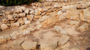
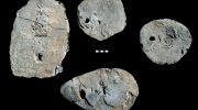
Archaeological remains around ancient harbors reveal how connected these cities were. Imported pottery from distant regions appears alongside local wares in the same layers of soil. Heavy stone anchors have been found reused in temples and public buildings, suggesting symbolic value tied to safe travel and divine protection.
Some cities featured wide streets leading directly to the docks, designed to move goods efficiently. These choices reflect planning shaped by maritime priorities rather than coincidence. Such details show that harbors influenced not only trade, but belief systems and urban design.
A Coastal Identity Takes Form
Through its harbors, Cyprus developed an outward-looking identity. The sea was not a boundary. It was a link. Coastal cities learned to balance openness with control, welcoming foreign goods and people while protecting local interests.
Harbor defenses, monumental architecture, and planned layouts sent messages to arriving ships. Cyprus was organized, prosperous, and ready to engage. This maritime identity endured long after the Bronze Age ended.
Echoes Along the Modern Coast
Many modern Cypriot cities stand atop Bronze Age predecessors. Present-day waterfronts often follow ancient shorelines, even where harbors have shifted or vanished. Some ports now lie inland, transformed by silt and environmental change.
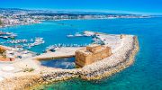
Archaeological sites preserve foundations, workshops, and harbor structures that hint at their former scale. Museums display ingots, tools, and imported goods recovered from these areas, reconnecting the island to its maritime past.
Why These Harbors Still Matter
Bronze Age harbors were the engines of early Cypriot civilization. Through them flowed copper, goods, people, and ideas. They allowed a small island to exert influence across a vast sea.
Understanding these gateways explains Cyprus itself. The island’s history was shaped not by isolation, but by connection. From the Bronze Age onward, its coastal cities looked outward, using the sea to turn geography into opportunity and harbors into foundations of power.