Cyprus mountain roads offer some of the Mediterranean’s most spectacular drives, with routes that climb from sea level to nearly 2,000 meters through ancient forests, traditional villages, and panoramic viewpoints. These roads showcase the island’s dramatic geography while connecting travelers to centuries of history and natural beauty.

Mount Olympus Road
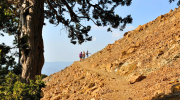
The road to Mount Olympus climbs to 1,952 meters above sea level, making it the highest point on the island. Two military bases occupy the summit, one British, limiting public access to the very top. However, roads leading toward the peak provide stunning views of surrounding valleys and forests.

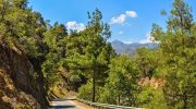
The journey starts from several possible directions, with routes from Limassol through Platres being among the most popular. The ascent features countless switchbacks and hairpin turns as the road gains elevation. Dense pine forests cover the mountainsides, giving way to more exposed terrain at higher altitudes. Winter transforms this area into Cyprus’s only ski destination, with snow covering the peaks from January through March.
Drivers should fill fuel tanks before attempting the climb because petrol stations become scarce above 1,000 meters. The temperature drops noticeably with altitude, sometimes falling 10 degrees Celsius cooler than coastal areas. This makes the mountain roads a welcome escape during summer heat but creates challenging conditions in winter when ice forms on shaded sections.
Cedar Valley Road
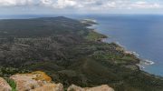
Cedar Valley Road runs 16.5 kilometers through the Paphos Forest, connecting to the E740 road at both ends. This paved mountain route features hundreds of tight curves and dramatic elevation changes. The road serves as the primary access to an ecosystem containing approximately 130,000 Cyprus cedars, an endemic subspecies related to Lebanese cedars found nowhere else on Earth.
The Cedar Valley sits at approximately 1,150 meters elevation, nestled between the villages of Lysos to the west, Pano Panagia to the south, Tsakistra to the east, and Pyrgos and Pomos to the north. The imposing Tripylos peak rises to nearly 1,400 meters just northwest of the valley floor. From this elevation, panoramic views extend across much of the Paphos Forest, northward to Morphou Bay, and west toward the Akamas Peninsula.
The drive through Cedar Valley tests even experienced drivers with its endless switchbacks. Those prone to motion sickness should take precautions or consider alternative routes. However, the journey rewards travelers with crystal-clear mountain air, unique horizontal layering visible in mature cedar trees, and chances to spot the mouflon wild sheep that serve as Cyprus’s national symbol. Several thousand mouflon roam freely throughout Paphos Forest, though sightings remain rare due to their elusive nature.
The valley includes picnic facilities with concrete cooking areas designed to prevent forest fires, wooden playground equipment for children, water taps, and restroom facilities. Cypriots particularly favor this spot during summer months when the shade beneath towering trees provides relief from coastal heat. Three hidden Venetian bridges, Skarfou, Tzelefou, and Routhkia, can be explored on foot for those willing to hike into the forest.
Routes Connecting Major Villages in the Troodos Range
Multiple roads link traditional mountain villages throughout the Troodos region. The route from Nicosia to Prodromos offers several variations depending on traffic, weather, and driver preference. One popular option runs through Evrychou, Galata, Kakopetria, Platania, areas outside Kyperounta, and Amiantos before reaching Platia Troodos square. This particular route features numerous curves and requires careful attention but delivers pure driving pleasure for those who enjoy technical roads.
The road from Platres to Troodos connects two major mountain centers through dense black pine forests. This well-maintained route sees regular traffic and provides access to numerous hiking trails, including the famous Artemis Trail that circles Chionistra mountain for 14 kilometers. The Caledonia Trail also starts near Platres, covering just 3 kilometers but requiring approximately 90 minutes to reach the waterfall at Psilo Dendro.
Kakopetria village serves as a major hub with roads radiating in multiple directions. The settlement features Palia Kakopetria, an old quarter with traditional architecture, and the 16th century Church of Agios Nikolaos. From here, drivers can access Prodromos, Troodos Square, or descend toward Nicosia. The village sits at a strategic junction where several valleys meet, making it ideal for exploring different areas of the mountain range.
Commandaria Wine Region Scenic Circuit
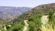
The Commandaria region spreads between 400 and 1,400 meters elevation on the southern slopes of Troodos. This area gives its name to the famous sweet wine known since ancient times. Homer and Hesiod both referenced this wine, originally called Nama Kyprion. The region features beautiful terraced vineyards planted with both native and international grape varieties.
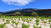
A circular route through Commandaria villages starts from Alassa near the Kouris Dam and climbs through Monagri, Doros, Lania, Trimiklini, Moniatis, and Pano Platres. The road continues through Foini, Agios Demetrios, Treis Elies, Kaminaria, and Lemithou before reaching Prodromos at the highest elevations. This circuit showcases how traditional agriculture adapted to mountainous terrain through extensive terracing.
Views from these roads take in Limassol city on clear days, along with the Salt Lake and Akrotiri Peninsula to the south. Looking north from higher elevations, the central Mesaoria plain stretches toward Nicosia, with the Pentadaktylos Mountains visible in the distance. The contrast between coastal development and mountain tranquility becomes especially apparent from these vantage points.
Marathasa Valley Road Network
The Marathasa Valley contains several significant villages connected by winding mountain roads. Prodromos sits at 1,499 meters elevation and serves as one of the highest settlements on the island. From here, trails offer panoramic views of the valley, Morfou Bay, Kykkos Monastery, and surrounding peaks. The Fragma Prodromou nature trail starts from the dam of the same name and provides access to dense black pine forests.
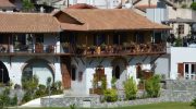
Pedoulas and Kalopanayiotis are two other major Marathasa villages worth visiting. Pedoulas features chocolate-making experiences and traditional architecture. Kalopanayiotis hosts the Casale Panayiotis luxury hotel, restored from traditional houses, along with the monastery of Agios Ioannis Lampadistra and the Marathasa Winery.
The road to Kykkos Monastery climbs above 4,000 feet and ranks among the most impressive monastery approaches in Cyprus. Founded in the 11th century under Byzantine rule, Kykkos contains stunning frescoes, detailed architecture, and legendary icons including a miraculous Virgin Mary painting. The journey to reach this mountain peak sanctuary offers spectacular views that change with each curve of the road.
Akamas Peninsula Coastal Mountain Combination
The Akamas Peninsula in northwest Cyprus provides a different type of scenic drive, combining coastal views with mountain access. This protected natural park starts from Paphos and follows the coast through Polis before reaching the Baths of Aphrodite, a natural grotto where legend claims the goddess of love once bathed.

Roads into Akamas traverse varied terrain from sea level beaches to forested hillsides. The peninsula supports diverse wildlife and remains relatively undeveloped compared to other coastal areas. Drivers can expect narrow roads in some sections, particularly when accessing remote beaches or hiking trail starting points. The contrast between azure Mediterranean waters and green hillsides creates memorable vistas.
Wildlife and Natural Features Along Scenic Routes
The endemic Cyprus cedar grows exclusively in high-altitude forests, distinguished by horizontal branching patterns quite different from other conifers. These protected trees fall under European Natura 2000 network conservation programs. Mature specimens display the distinctive layered appearance that makes them instantly recognizable.
Golden oak trees, another endemic species, grow alongside cedars in certain elevations. The combination creates unique forest ecosystems found nowhere else in Europe. Black pine forests dominate other elevation bands, particularly around Mount Olympus where some juniper trees exceed 800 years old.
Birdwatchers appreciate mountain roads for access to diverse avian species. Endemic and migratory birds frequent different elevation zones throughout the year. Mammals like foxes, hares, and hedgehogs inhabit the forests, though mouflon remain the most sought-after sighting despite their scarcity.
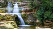
Several waterfalls become accessible via mountain roads, including the Caledonia waterfall near Platres and the Millomeris waterfall. These water features prove most impressive during spring when snowmelt swells mountain streams. The medieval Milia Bridge near Platres spans the Kryos River in a shaded spot particularly beautiful during autumn when water pools below the stone arches.
Road Quality and Maintenance Standards
Major mountain routes maintain excellent pavement quality thanks to regular maintenance by the Public Works Department. The A-class roads like those approaching Troodos from multiple directions feature smooth surfaces, clear lane markings, and well-designed curves. However, secondary roads connecting smaller villages may show more wear, with occasional potholes or cracked pavement.

Forest roads maintained by the Forestry Department serve primarily management purposes and may remain unpaved. These routes provide access to hiking trails and remote areas but require careful driving and sometimes four-wheel drive capability. Regular passenger cars risk damage on rough forest tracks.
Signage throughout mountain areas appears in both Greek and English, making navigation straightforward for international visitors. Distance markers use kilometers, and warning signs alert drivers to sharp curves, steep grades, and other hazards. Brown tourist signs direct travelers toward monasteries, archaeological sites, picnic areas, and nature trails.