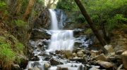
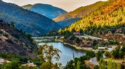
Cyprus contains a surprising network of waterfalls and natural springs hidden within the Troodos mountain range. These water features flow year-round despite the island’s reputation as a dry Mediterranean destination. The mountains capture rainfall that would otherwise evaporate in coastal plains, creating conditions where water persists through even the hottest summers.
Most waterfalls cluster between 650 and 1,600 meters elevation where annual precipitation reaches 1,000 millimeters compared to 300 millimeters at sea level. The Troodos region produces 80 percent of Cyprus’s surface water, feeding rivers that supply reservoirs and aquifers across the island.
These waterfalls and springs formed over millions of years as mountain streams carved through volcanic diabase and limestone rock, creating spectacular cascades surrounded by dense pine forests, golden oak trees, and endemic plant species found nowhere else on earth.
Ancient Water Sources That Shaped Civilization
Cyprus earned the name “green island” in ancient times because its forests extended from mountain peaks to coastlines, sustained by abundant surface and spring water. Archaeological evidence shows Neolithic settlers around 7000 BCE chose locations based entirely on water availability.
Ancient Kourion featured sophisticated water systems with terracotta pipes fed by perennial springs near Sotira. Salamis constructed a 40-kilometer aqueduct connecting the city to water sources in the Kyrenia hills, demonstrating the engineering lengths civilizations pursued to secure reliable water.
The therapeutic properties of certain springs attracted attention from rulers throughout history. Kings from Soloi visited the Marathassa region during Roman, Byzantine, and Frankish eras specifically for spa treatments at sulphur springs near Kalopanagiotis. According to Kostas Myriantheas, a healing spa operated at the monastery of Agios Irakleidiou, dedicated to the god Asclepius.
Characteristics of Major Water Features
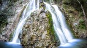
Millomeris Waterfall
Millomeris Waterfall stands as Cyprus’s tallest at 15 meters, located along the Kryos Potamos River between Platres and Pera Pedi villages. The name derives from Greek words “millos” and “meros” meaning moist place, reflecting the perpetually damp environment created by minimal sunlight penetration.
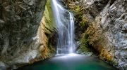
Water cascades over diabase rock into a small pool several meters wide at the base. The waterfall maintains flow throughout summer months due to constant feeding from higher mountain sources. Dense pine forest and golden oak trees surround the site, with endemic flowering shrubs creating microhabitats for rare plant species. The waterfall remained inaccessible until recent road extensions and trail construction opened it to visitors.
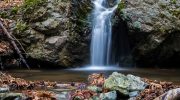
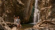
Caledonia Waterfall
Caledonia Waterfall measures 12 meters in height and ranks as Cyprus’s second largest. Scottish visitors discovered the site in 1878 during the British colonial period and named it after their homeland due to resemblance to Scottish landscapes.
The waterfall sits at 1,330 meters altitude approximately two kilometers north of Pano Platres village. Water descends from basalt cliffs into a shallow rocky pool, maintaining year-round flow that persists even during hot summer months. The 1.4-kilometer nature trail to reach Caledonia winds alongside and over the Kryos Potamos River through woodland filled with pine, oak, nightingales, and aromatic herbs.
Kalopanagiotis Thermal Springs
The Kalopanagiotis thermal springs contain sulphur compounds recognized for therapeutic properties since ancient times. These springs flow near the banks of the Setrachou River next to a Venetian bridge.
The water emerges naturally heated from underground sources, maintaining consistent temperatures suitable for bathing year-round. Modern spa facilities utilize these waters for treatments addressing various ailments.
The springs feed into river systems that support trout populations, making the area popular for fishing. Pedoulas village hosts a natural spring locals claim holds the key to longevity, drawing visitors who stop for refreshing drinks believed to promote health and long life.
Remarkable Details About Mountain Waters
The island’s water balance reveals complex hydrology. Annual precipitation totals 900 million cubic meters across Cyprus, but approximately 77 percent evaporates before entering water systems. Surface runoff accounts for 13 percent or 830 million cubic meters yearly.
The remaining 10 percent becomes groundwater, with natural aquifer recharge estimated at 300 million cubic meters. Of this groundwater, 70 million cubic meters flows directly to the sea while 100 million cubic meters emerges through springs. During normal rainfall years, Cyprus generates renewable water resources sufficient for basic needs. However, variations in precipitation create periodic droughts that stress the entire system.
Troodos waterfalls display seasonal variations in flow volume while maintaining year-round presence. Winter rains from December through February swell rivers and increase waterfall power dramatically.
Spring months from March through May showcase waterfalls at peak beauty with maximum flow combined with blooming wildflowers and green vegetation. Summer reduces flow to steady streams rather than torrents, but cooling mist and shade make waterfalls popular swimming destinations.
Autumn brings moderate flows as early rains begin replenishing river systems before winter arrives. This persistence distinguishes Cyprus waterfalls from those in mainland Greece or Turkey, where many dry completely during summer months.
Geological and Ecological Significance
The Troodos mountain range originated as oceanic crust pushed above sea level approximately 90 million years ago during tectonic plate collisions. This ophiolite formation created unique rock types including diabase, basalt, gabbro, and serpentine.
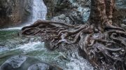
Water flowing over these volcanic rocks dissolves minerals, creating crystal-clear streams infused with beneficial compounds. The geological diversity produces waterfalls with distinct characteristics based on underlying rock composition.
Diabase creates sheer vertical drops like Millomeris, while softer rocks produce cascading multi-tiered falls.
Vegetation around waterfalls differs dramatically from lowland Cyprus. Pine trees dominate at higher elevations, creating dense forests that shade water sources and reduce evaporation. Golden oak trees grow abundantly near springs and streams, their roots stabilizing soil and preventing erosion.
Endemic plant species including Cyprus cyclamen, rock roses, and various orchids thrive in moist microclimates near waterfalls. The cool, humid conditions support species normally found much farther north in Europe. Birds including nightingales, warblers, and woodpeckers inhabit these forest environments, creating rich biodiversity hotspots.
The water quality of Troodos springs supports specialized ecosystems. Trout survive in cold mountain streams fed by snowmelt and spring water, representing the only fish species thriving at these elevations.
Kalopanagiotis dam became famous as a trout fishing destination due to deep cold waters maintaining year-round suitable temperatures. The springs produce water so pure that Kykkos Natural Mineral Water sources its product directly from forest springs in western Troodos.
Modern Water Management and Conservation
Cyprus constructed over 100 dams with total capacity of 330 million cubic meters, giving it the largest number of dams per square kilometer and largest storage volume per capita of any European country. This massive infrastructure developed after the 1970s when underground aquifers became exhausted from decades of over-extraction.
Dam construction focused on steep Troodos valleys to capture winter surface water.
The system proved essential but insufficient during severe droughts. In 2008, Cyprus became the first European Union country to face “peak water” where demand exceeded natural supply capacity.
Four consecutive drought years emptied reservoirs, overwhelmed desalination plants, and brought areas near desert conditions. Weekly water cuts affected the population while emergency measures included drilling for groundwater and importing water by ship from Greece, with tankers delivering 40,000 to 50,000 cubic meters daily from July through November.
Visiting the Waterfalls and Springs Today
Caledonia Waterfall
Caledonia Waterfall offers the most accessible experience with well-maintained trails suitable for families. The 1.4-kilometer nature trail starts either near Psilo Dendro restaurant or from parking areas near Pano Platres village.
The southern route provides gentler terrain while the northern section presents more challenging rocky paths. Bridges and steps aid passage over difficult sections. The round-trip typically requires one to two hours depending on pace and rest stops.
Rocky sections become slippery after rain or snowfall, making proper footwear essential. The trout farm near the trail serves fresh local fish and provides convenient access points.
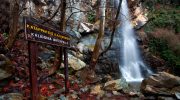
Millomeris Waterfall
Millomeris Waterfall requires more effort but rewards visitors with greater privacy and less crowding than Caledonia. From Limassol, the drive takes 45 to 50 minutes.
Small parking areas near the trailhead fill quickly during peak seasons, forcing some visitors to park along roadsides. A 1.2-kilometer downhill trail leads from parking to the waterfall through pine forest. Concrete steps assist passage over steep sections.
Kalopanagiotis Thermal Springs
Kalopanagiotis thermal springs operate as public facilities near the village center adjacent to the Venetian bridge. The sulphur springs flow naturally into designated bathing areas.
Spa facilities offer various treatments utilizing the mineral waters. The village provides accommodations, restaurants serving traditional Cypriot cuisine, and access to hiking trails.
The nearby Monastery of Agios Ioannis Lambadistis, a UNESCO World Heritage Site, features Byzantine churches with frescoes dating from the 9th to 15th centuries.
What Makes Cyprus’ Waterfalls Truly Iconic
Waterfalls and springs represent survival in the Mediterranean’s challenging climate. The Troodos mountains create conditions where water persists when surrounding regions face drought.
This geographical quirk allowed ancient civilizations to flourish and continues sustaining modern populations. The waters connect past to present through continuous use patterns spanning millennia.
Villages that grew around springs remain inhabited because those water sources still flow. Hiking trails follow routes shepherds walked for centuries, maintaining traditional relationships between communities and landscapes.
The waters also symbolize resilience and adaptation. Despite deforestation, urbanization, agricultural intensification, and climate change, these mountain water systems continue functioning.
Conservation efforts protect remaining sources while residents learn to use water more efficiently. The springs remind Cypriots that their island once earned the title “green” through abundant water and forests.
Restoration projects aim to recover some of that lost abundance by replanting trees, managing watersheds, and protecting springs from over-extraction.