Explore Cyprus with Our Interactive Map

Explore our top stories and discover ideas worth your time.

Traditional Cypriot Baskets and Handwoven Village Crafts

Traditional Cypriot Baskets and Handwoven Village Crafts

Cyprus developed distinctive basket weaving and textile traditions that stretch back to ancient times. These crafts include water reed baskets from marshy regions, colorful Fythkiotika woven fabrics, and intricate Lefkaritika lace work. Each village specialized in particular techniques using locally available materials like reeds, cotton, and silk. trskinfo-ru The crafts served essential practical purposes in daily life while demonstrating artistic skill passed through generations. From storage vessels to dowry items, these handmade goods connected families to their heritage and provided economic livelihood in rural communities. Historical Background Basket weaving dates to Neolithic times, with techniques remaining essentially unchanged over millennia. Archaeological evidence shows woven items existed since the earliest settlements, with the craft spreading across all cultures worldwide. In Cyprus, basketry developed around two main centers. Larnaca and Akrotiri had naturally marshy landscapes perfect for growing water reeds, rushes, and bamboo used in basket construction. The Salt Lake and marshes attracted settlers to Akrotiri specifically because these materials enabled basket production that became central to village economy. vkcyprus-com Historical sources from 6 BCE document famous Cypriot weavers including Akisas and Elikon. Textile production flourished during Byzantine times when precious Cypriot silk and woolen fabrics earned reputations for exceptional quality throughout Europe. The craft reached its peak under Lusignan dynasty rule from 1192 to 1489. Italian writer Giovanni Boccaccio mentioned Cypriot…

Read more
Buffavento Castle Cyprus

Buffavento Castle Cyprus

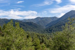
Buffavento Castle stands at 960 meters above sea level in the Kyrenia mountain range of Cyprus. This medieval fortress is the highest and least preserved of three Byzantine strongholds built along the mountains. The name comes from Italian and means "Defier of the Winds," a fitting description for a castle constantly exposed to mountain winds at this elevation. cycprusfaqs-com The castle sits between St. Hilarion Castle to the west and Kantara Castle to the east, forming a defensive line across the Kyrenia Mountains. All three castles are visible from each other, allowing them to pass signals and warnings. Buffavento guarded the mountain passage from Kythrea to the north coast, controlling movement between the coastal plain and the interior. The location provides views in every direction. Looking north across the Mediterranean Sea, visitors can see the Turkish coast approximately 65 kilometers away on clear days. To the south, the Mesaoria Plain stretches toward Nicosia. On exceptionally clear days, Famagusta to the east and the Troodos Mountains to the south are visible. The castle overlooks nearly half the island from its rocky peak. The steep cliffs surrounding the fortress made it naturally defensible. The north, east, and west sides are protected by sheer drops, with only the southern approach allowing access. Historical Background The exact construction date remains unknown, though most historians…

Read more
Troodos Ophiolite Cyprus

Troodos Ophiolite Cyprus

If you ever want to surprise someone in Cyprus, do not take them to a museum. Take them to Troodos. As you drive up from any direction you will first pass citrus groves, almond orchards and vineyards. Then pine appears. The air cools. The road winds higher. Somewhere above the clouds you stop, step out of the car and pick up a stone. Michal Klajban And you are holding a piece of the Earth that once lay kilometres beneath a vanished ocean. This is not a poetic exaggeration. Troodos is one of the very few places on the planet where a complete section of oceanic crust and upper mantle stands above sea level. What scientists normally reach only with deep-sea drilling ships, submarines and expensive research programmes lies here beside hiking paths, picnic sites and village roads. Within roughly fifty kilometres you can travel from rocks that formed deep inside the mantle to rocks that erupted on the seafloor, then into sediments that later surrounded the rising island. You are not simply climbing or going down a mountain. You are walking through the internal anatomy of the Earth itself. In the 1960s geologists were still debating whether continents actually moved. The theory of plate tectonics existed but needed proof. Troodos provided it. Here, predictions matched reality: magma chambers, feeder dykes…

Read more