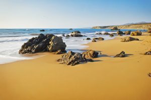
Explore Cyprus with Our Interactive Map

Explore our top stories and discover ideas worth your time.

Why Troodos Mountains Are a UNESCO Geopark

Why Troodos Mountains Are a UNESCO Geopark

The Troodos Mountains occupy the central part of Cyprus, covering approximately 1,147 square kilometers or about 15 percent of the island. UNESCO designated Troodos as a Global Geopark in 2015 due to its exceptional geological significance. The mountain range represents an ophiolite, which is an uplifted fragment of oceanic crust and upper mantle that formed 92 million years ago during the Upper Cretaceous period. bigstockphoto.com The highest peak, Mount Olympus, reaches 1,952 meters above sea level. What makes Troodos extraordinary is that the deepest rocks now sit at the highest elevations due to a dome structure created by tectonic forces. Visitors walking through Troodos can literally travel from the Earth's upper mantle to the ancient seafloor within a single day. The area contains 38 geosites that display this geological marvel, making it one of the most complete and best preserved ophiolite sequences in the world. Scientists consider Troodos the gold standard for understanding how oceanic crust forms and evolves. commons.wikimedia-org How ocean crust ended up on land The Troodos ophiolite formed in the Neotethys Ocean by seafloor spreading above a subduction zone approximately 92 to 82 million years ago. At that time, the African and Arabian tectonic plates were converging with the Eurasian plate. New oceanic crust formed as magma rose from the mantle and solidified at the spreading center.…

Read more
Lara Beach, Cyprus

Lara Beach, Cyprus

Lara Beach sits on the Akamas Peninsula in western Cyprus, roughly 27 kilometers northwest of Paphos. This stretch of golden sand is one of the Mediterranean's most important nesting sites for two endangered sea turtle species. Unlike the developed beaches that line most of Cyprus's coast, Lara remains untouched by commercial tourism. There are no sunbeds, no restaurants, and no permanent structures beyond a small conservation hut. The beach exists primarily for the turtles, with human visitors welcomed as guests rather than customers. tripadvisor-co Cyprus's First Turtle Conservation Station The protection of Lara Beach began in 1971 when the area was officially designated as a protected zone. In 1978, the Cyprus Fisheries Department launched a formal conservation project that included establishing a seasonal station and hatchery at Lara. This became the first turtle conservation project in the entire Mediterranean region. tripadvisor-co The initiative received support from the World Wildlife Fund between 1980 and 1983, followed by European Union assistance through the MedSPA Project in 1990. Today, government-funded conservationists maintain year-round monitoring of the nesting areas, though their presence intensifies during the breeding season. Green turtles and loggerhead turtles have nested on this beach for centuries. Both species are classified as endangered in the Mediterranean Sea by international conservation authorities. The green turtle population in the Mediterranean is critically endangered, making…

Read more
Royal Tombs of Tamassos In Cyprus

Royal Tombs of Tamassos In Cyprus

Southwest of Nicosia, near the modern village of Politiko, stand two monumental burial chambers that tell the story of ancient Cyprus's wealthiest inland kingdom. The Royal Tombs of Tamassos represent the height of 6th century BCE Cypriot architecture and demonstrate the immense prosperity that copper mining brought to this ancient city-kingdom. These tombs, carved from limestone blocks and built to resemble wooden houses, remain among the most impressive examples of pre-Hellenistic burial architecture on the island. googleusercontent-com The Royal Tombs of Tamassos are two monumental burial chambers constructed in the mid-6th century BCE. They belonged to the local rulers or elite aristocrats of the ancient city-kingdom of Tamassos, one of the ten major kingdoms of ancient Cyprus. The tombs were built using massive ashlar blocks of limestone and feature architectural details that imitate wooden construction techniques, including carved representations of roof beams and door locks. googleusercontent-com Historical Background Tamassos was strategically positioned near rich copper deposits in the northeastern foothills of the Troodos Mountains. The area had been inhabited since the Chalcolithic Age (around 3900 BCE), but population growth accelerated dramatically during the Late Bronze Age when copper mining intensified. By the 8th century BCE, Tamassos had developed into a major city-kingdom. The kingdom is mentioned in the Assyrian Prism of Esarhaddon from around 673-672 BCE, where it appears as…

Read more