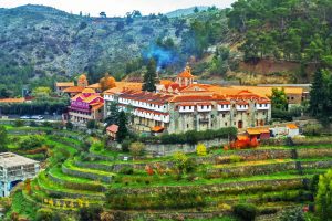
Explore Cyprus with Our Interactive Map

Explore our top stories and discover ideas worth your time.

Machairas Monastery

Machairas Monastery

Holy Monastery of Panagia Machaira is a historic monastery dedicated to the Virgin Mary located about 40 km from the capital of Cyprus, Nicosia. The monastery is built near Mount Kionia, at an elevation of 870 meters, and surrounded by dense pine forests. The monastery towers like a fortress on a steep hillside above the Pediaios River, Cyprus's longest waterway. shutterstock-com The Sacred, Royal and Stavropegic Monastery of the Virgin of Machairas ranks as one of the island's three most important monasteries alongside Kykkos and Agios Neophytos, holding special privileges that grant independence from the Archbishop of Cyprus. The Discovery of a Sacred Icon According to tradition, the icon is one of the seventy icons painted by the Apostle Luke. The icon had been placed above the Holy Soros, or reliquary, of the Virgin Mary in the Church of Blachernae in Constantinople. During the eighth century iconoclasm period when religious images faced destruction, a devout monk rescued the icon and brought it to Cyprus, hiding it in a cave where it remained forgotten for centuries. tripadvisor-com Around 1145, the hermits Ignatios and Neophytos, blessed with divine grace, discovered the cave which was obscured by bushes. To reach the cave where the icon was, a knife was given to them by a divine hand with which they used to cut the…

Read more
Cyprus Driving – Cities vs Mountains vs Village Roads

Cyprus Driving – Cities vs Mountains vs Village Roads

Cyprus offers drivers dramatically different experiences depending on where they travel. City streets demand alertness for roundabouts and parking challenges, mountain roads require careful handling on steep grades, and village lanes test patience with narrow passages. Understanding these differences helps drivers navigate the island safely and confidently. In-Cyprus-com Major cities like Nicosia, Limassol, and Paphos feature modern infrastructure with well-maintained roads, but they also present unique obstacles. Roundabouts appear frequently, especially at highway exits and major intersections. Traffic already on the roundabout has the right of way, so drivers must yield before entering. Local drivers move quickly through these circles, which can intimidate newcomers. Parking in city centers presents significant difficulties. Limassol has metered street parking along the seafront Molos promenade and in the old town, with pay-and-display machines requiring euro coins. Nicosia offers some free parking outside the Venetian walls along the moat, though finding a spot requires luck and patience. The old town streets are narrow, making it easy to accidentally block driveways or delivery zones. Traffic congestion hits peak levels during morning and evening rush hours. Nicosia sees particularly heavy traffic between 7:30 and 9:00 AM as commuters flood into the capital. The same pattern repeats between 5:00 and 6:30 PM when people leave work. Highway exits outside major cities require special caution because they are often…

Read more
Why Troodos Mountains Are a UNESCO Geopark

Why Troodos Mountains Are a UNESCO Geopark

The Troodos Mountains occupy the central part of Cyprus, covering approximately 1,147 square kilometers or about 15 percent of the island. UNESCO designated Troodos as a Global Geopark in 2015 due to its exceptional geological significance. The mountain range represents an ophiolite, which is an uplifted fragment of oceanic crust and upper mantle that formed 92 million years ago during the Upper Cretaceous period. bigstockphoto.com The highest peak, Mount Olympus, reaches 1,952 meters above sea level. What makes Troodos extraordinary is that the deepest rocks now sit at the highest elevations due to a dome structure created by tectonic forces. Visitors walking through Troodos can literally travel from the Earth's upper mantle to the ancient seafloor within a single day. The area contains 38 geosites that display this geological marvel, making it one of the most complete and best preserved ophiolite sequences in the world. Scientists consider Troodos the gold standard for understanding how oceanic crust forms and evolves. commons.wikimedia-org How ocean crust ended up on land The Troodos ophiolite formed in the Neotethys Ocean by seafloor spreading above a subduction zone approximately 92 to 82 million years ago. At that time, the African and Arabian tectonic plates were converging with the Eurasian plate. New oceanic crust formed as magma rose from the mantle and solidified at the spreading center.…

Read more