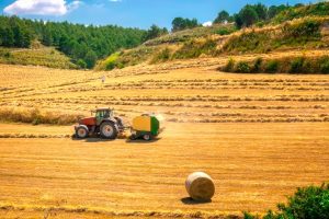
Agricultural Landscapes of Cyprus
Olive Groves, Vineyards, and Citrus Orchards Acting as Semi-Natural Habitats for Birds, Insects, and Pollinators Agricultural Landscapes as Modified Ecosystems in Cyprus represent human-altered terrains where traditional farming practices blend with natural processes, creating semi-natural habitats that support diverse wildlife. These landscapes, dominated by olive groves, vineyards, and citrus orchards, cover significant portions of the island's rural areas, providing food, shelter, and breeding grounds for birds like the Sardinian warbler, insects such as wild bees, and pollinators including carpenter bees. They illustrate Cyprus's agricultural heritage, where centuries of cultivation have shaped ecosystems that balance productivity with biodiversity, offering resilience in a Mediterranean climate prone to drought and erosion. https://www.youtube.com/watch?v=EliOkuH_qcQ A Modified Agricultural Mosaic Agricultural landscapes in Cyprus form a patchwork of cultivated fields and groves that integrate human management with ecological functions, spanning lowlands and hillsides across the island. Olive groves, covering around 15,000 hectares, thrive on calcareous soils with trees spaced to allow undergrowth, while vineyards, approximately 7,300 hectares mainly in the Troodos Mountains, feature terraced slopes that prevent soil loss. Citrus orchards, concentrated in the Morphou and Famagusta areas, occupy about 3,000 hectares with dense plantings that create microclimates. These systems receive 300-500mm of annual rainfall, relying on irrigation from dams and boreholes, and support over 100 bird species, 200 insect taxa, and vital pollinators that enhance crop…
Read more