Explore Cyprus with Our Interactive Map

Explore our top stories and discover ideas worth your time.

Kamares Aqueduct, Cyprus

Kamares Aqueduct, Cyprus

The Kamares Aqueduct stands as one of the most impressive monuments from Ottoman Cyprus. It was built in the 18th century to solve the city's water shortage. Water infrastructure was essential for urban centers throughout the Ottoman Empire. Cities needed reliable water sources to support growing populations, public baths, fountains, and agricultural activities. The Ottomans inherited Roman and Byzantine engineering knowledge and adapted these techniques to meet their needs. Cyprus became an Ottoman province in 1571 after the conquest of the Venetian-controlled island. Under Ottoman administration, Cyprus experienced periods of both prosperity and hardship. Water supply infrastructure represented one area where Ottoman governors made significant investments, recognizing that access to clean water directly affected public health and economic development. Aqueducts transported water from distant sources using gravity rather than mechanical pumps. The channels needed to be angled just enough for water to flow steadily without stagnating or moving so fast it damaged the structure. Historical Background By the mid-18th century, Larnaca had grown into an important commercial port on Cyprus's southern coast. Mediterranean trade brought increasing numbers of merchants, sailors, and residents to the city. This population growth created a serious problem: Larnaca lacked sufficient local water sources. The nearest reliable springs and the Tremithos River (also called the Arpera River) lay approximately 10 kilometers away from the city center.…

Read more
Akrotiri Peninsula

Akrotiri Peninsula

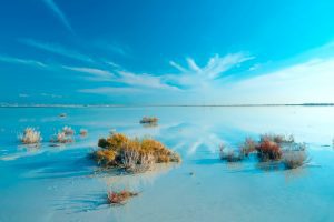
The Akrotiri Peninsula in the Limassol District marks the southernmost tip of Cyprus and also the southernmost part of Europe. This 123 square kilometer area contains the largest complex of natural wetlands on the island, centered around Akrotiri Salt Lake. The peninsula hosts over 300 recorded bird species, more than 800 indigenous plant species representing roughly 40 percent of all plants found on Cyprus, and critical habitats ranging from coastal sand dunes to Mediterranean juniper forests. Most of the peninsula lies within the British Sovereign Base Area of Akrotiri, territory retained by the United Kingdom when Cyprus gained independence in 1960. From Ancient Island to Protected Reserve The Akrotiri Peninsula was once a small island that merged with the rest of Cyprus through processes spanning thousands of years, creating what geologists call a double tombolo. The Kouris River carried sediment to create a land bridge on the western side at least 56,000 years ago, while the Garilis River later formed a second connection on the eastern side. This gradual process trapped seawater between the two land bridges, forming Akrotiri Salt Lake. The south cliffs of the peninsula, known as Aetokremmos, host the earliest known archaeological site in Cyprus and are believed to be the first part of the island inhabited by people during the pre-Neolithic period. The site contains 12,000-year-old…

Read more
A Sea Raised Into The Sky

A Sea Raised Into The Sky

Pick up a stone almost anywhere in Cyprus and there is a fair chance it once lay two or three kilometres beneath an ocean. Stand on a Troodos peak and you are standing deeper than the deepest submarine canyon of the Mediterranean ever reaches today. Walk along a riverbed in Paphos region after winter rains and you may notice greenish rocks polished smooth by water: the same minerals astronauts search for on Mars because they can form where life begins. Cyprus is not just an island with mountains. It is a place where the Earth accidentally turned itself inside out. Geologists often say walking across Cyprus is like reading a history book backwards. Instead of digging down into the planet’s past, the past has been lifted up for you. You begin your journey on younger coastal plains and finish it on the deep mantle that once had lied beneath the seabed. You are quite literally walking on a vanished ocean floor. And the strangest part? This tiny island is connected, geologically, to the “rooftop of the world” the Himalayas themselves. 1. Where we are? But also, when we are? On a map, Cyprus looks like a small island in the Eastern Mediterranean. In reality, it is a meeting point of continents, oceans, and geological time. The Troodos Mountains rise in…

Read more