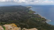
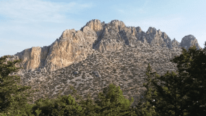
The Besparmak Mountains stretch like a limestone backbone along the northern coast of Cyprus, parallel to the Mediterranean for approximately 160 kilometers. Known also as the Kyrenia Mountains or Pentadaktylos, this narrow ridge rises abruptly from the coastal plain to create one of the island’s most dramatic landscapes. The name Besparmak translates to five fingers in Turkish, referring to a distinctive peak that resembles an outstretched hand.
- Ancient Limestone from the Mesozoic Era
- Endemic Plants on Limestone Cliffs
- Birds and Reptiles of the Mountain Range
- Three Medieval Castles Guard the Peaks
- Legends Behind the Five Finger Peak
- Outdoor Recreation and Adventure Tourism
- Fire History and Conservation Needs
- Geological Heritage and Future Protection
Ancient Limestone from the Mesozoic Era
The range consists primarily of hard crystalline limestone with some dolomite and marble formations dating to the Mesozoic period, formed between 250 and 65 million years ago beneath ancient seas. Unlike the volcanic Troodos Mountains in southern Cyprus, this northern range represents sedimentary formations from the Permian to Middle Miocene periods, pushed upward by collision of African and Eurasian tectonic plates.
The highest peak, Mount Selvili Tepe, reaches 1,024 meters near Lapta. While only half the height of Troodos, the Kyrenia Mountains appear more imposing because they rise suddenly from the flat Mesaoria plain. The porous limestone acts as a natural filter, creating mountain aquifers that supply nearly all towns and villages in northern Cyprus.
Endemic Plants on Limestone Cliffs
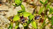
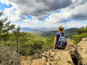
The limestone cliffs support diverse flora. Cyprus hosts 1,750 native plant species, of which 128 are endemic. The Kyrenia range contains 57 endemic species, concentrated at higher elevations. Seven important plant areas have been identified: Alevkaya, Buffavento, Besparmak, Kivanctepe, Karmi, St. Hilarion, and Kantara.
Critically endangered Delphinium caseyi exists only at the summit of two rocky peaks in the western range. Other rare endemics include Teucrium cyprium subspecies kyreniae found in limestone crevices and Arabis cypria on shaded rocks. These narrow endemics depend entirely on specific locations for survival.
Pine and cypress forests clothe the mountains, with Turkish pine dominating northern slopes. Deciduous trees including arbutus, holm oak, fig, and walnut grow throughout. Research identifies 14 European Union habitat types here, three classified as priority habitats. Most significant are calcareous rocky slopes with chasmophytic vegetation and limestone pavements.
Birds and Reptiles of the Mountain Range
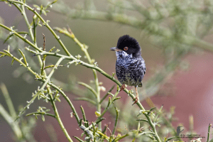
The Kyrenia range provides critical habitat for endemic and migratory birds. Cyprus hosts 380 bird species due to its position on migration routes between Africa, Europe, and western Asia. Two endemic songbirds breed exclusively here: the Cyprus warbler and Cyprus wheatear. Raptors nest in limestone cliffs, and spring and autumn bring migratory species including Eleonora’s falcon and imperial eagles.
Reptile diversity includes the Cyprus whip snake and venomous Cyprian blunt-nosed viper. The viper, though not aggressive, possesses potent venom dangerous to large mammals. The European cat snake and Montpellier snake also inhabit the rocky terrain, along with the harmless European blind snake.
Three Medieval Castles Guard the Peaks
Three magnificent medieval castles sit astride Kyrenia peaks: St. Hilarion, Buffavento, and Kantara. Dating from the 10th through 15th centuries, constructed by Byzantines and Lusignans, their strategic locations allowed control of pass roads and provided early warning of approaching ships.
St. Hilarion Castle
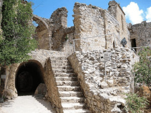
St. Hilarion Castle at 732 meters is the best preserved. Named after a hermit monk who established a cave hermitage here in the 4th century, the site later hosted a Byzantine monastery. Starting in the 11th century, Byzantines fortified it against Arab pirate raids. The Lusignan dynasty expanded it in the 13th century as both military outpost and royal summer residence. The castle has three levels with the upper ward housing royalty and offering spectacular views of Kyrenia harbor.
Buffavento Castle
Buffavento Castle stands highest at 960 meters. Its Italian name means protected from the wind, though wind constantly batters the summit. Built between the 7th and 11th centuries, it served as an observation post with signal connections to neighboring castles. The structure saw little military action except when Richard the Lionheart captured Cyprus in 1191.
Kantara Castle
Kantara Castle, the easternmost fortress at 630 meters, controlled entrances to the Karpas Peninsula and Mesaoria plain. Its name derives from Arabic qantara, meaning small bridge, reflecting its role linking the northern coast to Famagusta. First mentioned historically when Byzantine ruler Isaac Comnenus took refuge there from Richard the Lionheart in 1191, it was severely damaged in 1228 during power struggles. On clear days visitors see Lebanon and Syria 150 kilometers across the sea.
The three castles communicated through signals, with Buffavento serving as central relay. Venetians who acquired Cyprus in 1489 found these fortresses obsolete by 1519. The last garrisons departed in 1525, and Kantara was dismantled in 1560.
Legends Behind the Five Finger Peak
The distinctive five-fingered peak has inspired multiple legends. One tells of a conceited villager who loved a queen and requested her hand in marriage. The queen demanded he bring water from the distant spring of Apostolos Andreas monastery. After weeks of perilous travel, he returned with the precious water. She still refused him, and in rage he poured the water out, seized a handful of mud, and hurled it at her head. She dodged, and the mud sailed across the plain to land atop the mountain, preserving his five fingers.
Another legend credits Byzantine hero Digenis Akritas, who tradition says leapt across the sea from Anatolia to save Cyprus from Saracen invaders. His hand gripped the mountain to pull himself from the water, leaving his heroic handprint. A third tale claims giants populated the ancient world, and one aimed rocks at an opponent, missed, and the stones landed on the hillside to form the five-finger ridge.
Modern politics have also marked the slopes. A massive flag of the Turkish Republic of Northern Cyprus is painted on the southern face, measuring 425 meters wide and 250 meters high. Illuminated at night, this controversial landmark is visible for kilometers.
Outdoor Recreation and Adventure Tourism
The Kyrenia Mountain Trail stretches 220 kilometers along the ridge, offering one of the Mediterranean’s most challenging long-distance treks. The trail passes through all major peaks and connects the three castles. Shorter routes lead to specific destinations like St. Hilarion, where steep paths climb through pine forests.
Three main passes cut through the range, carrying vehicle traffic. Other tracks wind through mountains for hikers seeking solitude. Higher elevations offer cooler temperatures, providing escape from coastal heat when lowlands exceed 35 degrees Celsius. Rock climbing opportunities exist on limestone cliffs with bolted routes. Paragliding launches operate from peaks at 750 to 800 meters, with optimal conditions in spring and autumn.
Fire History and Conservation Needs
In July 1995, a devastating fire burned for three days through large portions of the mountains, destroying significant forest and habitat. Fire breakers now run alongside slopes to prevent future catastrophes, yet the region remains vulnerable during hot, dry summers.
Conservation challenges include building developments along foothills, quarrying activities that damage limestone formations, and lack of comprehensive development policy. Narrow endemic plants are particularly at risk as habitat destruction eliminates their only growing locations. Climate change predictions suggest increasing drought and fire weather ahead.
Despite pressures, the mountains maintain disproportionate ecological importance. Limestone aquifers store and filter essential water. Forests regulate microclimates and prevent soil erosion. Endemic species represent evolutionary adaptations found nowhere else. Conservation initiatives focus on protecting seven important plant areas identified through surveys from 2007 to 2015.
Geological Heritage and Future Protection
The Besparmak Mountains represent more than scenic backdrop to Cyprus’s northern coast. These limestone ridges, thrust upward millions of years ago, create habitats for species that evolved in isolation over geological time. The 57 endemic plants demonstrate how harsh limestone soils drove specialized adaptations. Medieval castles on strategic peaks remind visitors that humans have valued these heights for centuries.
The mountains serve essential functions today. They capture winter rainfall and store it in porous aquifers. They provide cooler refuges from coastal heat. They host migratory birds traveling between continents. They protect narrow endemics found nowhere else worldwide. The karst features and calcareous slopes constitute priority habitats under European conservation directives.
Visitors who hike to castle ruins or climb challenging trails encounter landscapes shaped by ancient geology and human history. The five-fingered peak visible for miles symbolizes the range’s distinctive character. Whether viewed from coastal towns or explored via winding footpaths, the Besparmak Mountains remain central to northern Cyprus’s natural heritage and cultural identity. Their limestone bones, clothed in pine and cypress, will continue standing as they have for millions of years, assuming conservation efforts protect the endemic species and forest ecosystems that make these mountains unique.