Geography and geology of Cyprus

Articles: Geography and geology of Cyprus

Stories in this category and its subcategories.

Mesaoria Basin Cyprus

Mesaoria Basin Cyprus

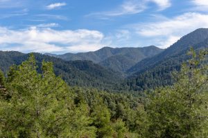
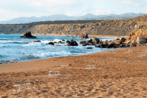
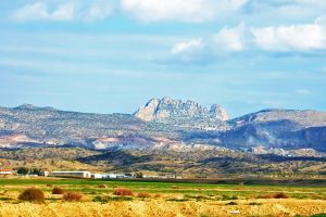
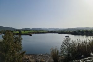
Stand on a small hill just outside Nicosia and look around. To the south the Troodos Mountains rise dark and rugged on the horizon, their volcanic slopes fading into forests. To the north the Kyrenia range appears as a long pale wall of limestone cliffs or rugged forms stretching as far as the eye can see. Between them lies an immense open landscape. Vasily Papkovskiy This is Mesaoria. In Greek it literally means “between the mountains”. This basin forms a natural wide corridor across the island, a broad open landscape framed by two very different geological worlds. At first glance the region may appear quiet compared with the dramatic mountains that surround it. There are no towering cliffs or deep…

Read more
Troodos Ophiolite Cyprus

Troodos Ophiolite Cyprus

If you ever want to surprise someone in Cyprus, do not take them to a museum. Take them to Troodos. As you drive up from any direction you will first pass citrus groves, almond orchards and vineyards. Then pine appears. The air cools. The road winds higher. Somewhere above the clouds you stop, step out of the car and pick up a stone. Michal Klajban And you are holding a piece of the Earth that once lay kilometres beneath a vanished ocean. This is not a poetic exaggeration. Troodos is one of the very few places on the planet where a complete section of oceanic crust and upper mantle stands above sea level. What scientists normally reach only with deep-sea…

Read more
Mamonia Mélange Cyprus

Mamonia Mélange Cyprus

You can arrive at Mamonia without planning to. You stop to watch the sunset near Petra tou Romiou. You follow a narrow road inland from Paphos. You walk a riverbed after winter rain and pick up a stone that feels heavier and smoother than it should. The land looks familiar yet slightly unsettled. A hillside glows deep red. A green rock appears among pale gravel. A white cliff rises abruptly above darker slopes. VasilyPapkovskiy It takes a moment to realise the reason. You have not left Cyprus. You have stepped onto land that existed before the island itself. The Mamonia Mélange, a geological area occupying a large portion of West Cyprus: from Akamas Peninsula to Petra Tou Romiou and all…

Read more
A Sea Raised Into The Sky

A Sea Raised Into The Sky

Pick up a stone almost anywhere in Cyprus and there is a fair chance it once lay two or three kilometres beneath an ocean. Stand on a Troodos peak and you are standing deeper than the deepest submarine canyon of the Mediterranean ever reaches today. Arrival Guides Walk along a riverbed in Paphos region after winter rains and you may notice greenish rocks polished smooth by water: the same minerals astronauts search for on Mars because they can form where life begins. Cyprus is not just an island with mountains. It is a place where the Earth accidentally turned itself inside out. Geologists often say walking across Cyprus is like reading a history book backwards. Instead of digging down into…

Read more
Kakopetria Gorge Cyprus

Kakopetria Gorge Cyprus

Kakopetria Gorge forms around the meeting point of two permanent mountain streams in the Troodos range. The Karkotis and Garillis rivers converge in this valley at 667 meters elevation, creating the Klarios River that flows 24.75 kilometers to Morphou Bay. The gorge sits in the heart of the Solea Valley, 55 kilometers from both Nicosia and Limassol, surrounded by dense pine forests and traditional stone villages that have preserved their character for centuries. chooseyourcyprus.com The gorge takes form along the banks of two rivers that maintain year-round flow, unusual for Cyprus where most streams run dry during summer. The Karkotis originates from the northwestern slopes of Papoutsa peak, while the Garillis flows from the northeastern slopes of Mount Troodos. Hundreds…

Read more
Rugged Coastlines of Cyprus

Rugged Coastlines of Cyprus

The rugged coastlines of Cyprus display dramatic geological contrasts where limestone cliffs plunge into turquoise Mediterranean waters, creating landscapes that combine raw natural beauty with mythological significance. The island's 648-kilometer coastline features two primary wild areas, the Akamas Peninsula in the northwest and Cape Greco in the southeast, both protected under the Natura 2000 European network. Shutterstock-com These areas showcase calcitic sandstones formed during glacial periods over the last 100,000 years, raised marine terraces representing ancient coastlines lifted by Cyprus's gradual tectonic uplift, and deep gorges carved through limestone bedrock by erosion. The Akamas covers 230 square kilometers with elevations reaching 419 meters, while Cape Greco's lower terrain emphasizes coastal features including sea caves, natural rock bridges, and vertical cliffs…

Read more
Limassol Lefkosia Fault Zones

Limassol Lefkosia Fault Zones

The Limassol-Lefkosia region contains several major fault systems, with the Southern Troodos Transform Fault Zone being the most significant. This fault zone runs along the southern margin of the Troodos ophiolite, the massive block of ocean floor rock that forms the central mountains of Cyprus. The fault is at least 5 kilometers wide in some places and trends east to west across the island. mail-com Transform faults are places where two tectonic plates slide horizontally past each other rather than colliding or pulling apart. The Southern Troodos Transform Fault formed around 90 million years ago on the ocean floor when Cyprus was still underwater. The fault separated two spreading ridges where new ocean crust was being created, much like the…

Read more
Semi-Arid Inland Plains Climate (Mesaoria)

Semi-Arid Inland Plains Climate (Mesaoria)

Semi-Arid Inland Plains Climate (Mesaoria) is characterized by low rainfall and hot summers, a pattern that has shaped Cyprus's central lowlands with drought-resistant vegetation and adapted agricultural practices. This climate, with annual precipitation under 350mm and temperatures soaring above 40°C in July-August, creates a landscape of dry riverbeds, thorny shrubs, and resilient crops like barley. It influences everything from biodiversity to human settlement, highlighting how the island's interior has fostered unique ecosystems and cultural responses to aridity. A Harsh Yet Resilient Inland Environment The Mesaoria Plains, often called the "breadbasket" of Cyprus, span the island's central region between the Troodos and Kyrenia Mountains, covering approximately 2,500 square kilometers. This semi-arid zone experiences extreme seasonal contrasts, where scorching summers give way…

Read more