Explore Cyprus with Our Interactive Map

Explore our top stories and discover ideas worth your time.

Kalavasos Tenta, Cyprus

Kalavasos Tenta, Cyprus

Four kilometers from the village of Kalavasos, on a small hill overlooking the Vasilikos River valley, archaeologists uncovered one of Cyprus's earliest permanent settlements. Kalavasos-Tenta dates to around 8000-6000 BC and predates the more famous Choirokoitia by nearly a millennium. Today, a distinctive cone-shaped shelter protects the circular stone houses where some of the island's first farming communities lived over 9,000 years ago. Kalavasos-Tenta is an Aceramic Neolithic settlement located 38 kilometers southwest of Larnaca and 45 kilometers south of Nicosia. The site occupies a naturally defensible hill on the west side of the Vasilikos valley, positioned to command views of the surrounding agricultural land and the river that provided water for crops and livestock. The settlement represents the Aceramic Neolithic period, meaning its inhabitants lived before pottery was introduced to Cyprus. Archaeological evidence shows occupation from around 8000 BC through the 6th millennium BC, making it contemporary with other early Cypriot sites like Shillourokambos and Mylouthkia. The population during its peak likely never exceeded 150 people based on the size and number of structures excavated. According to local tradition, the site's name derives from a much later event in 327 AD, when Saint Helena, mother of Constantine the Great, stayed in a tent at this location during her visit to Cyprus following the discovery of the True Cross in…

Read more
Karpasia Peninsula Climate

Karpasia Peninsula Climate

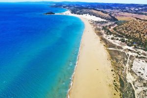
Karpasia Peninsula Sub-Humid Climate is marked by a slightly wetter profile in Cyprus's northern region, supporting lush scrub, wetlands, and seasonal agriculture. This climate, with higher rainfall than the island's interior, creates diverse habitats from coastal dunes to inland plains, fostering unique biodiversity and human activities. It shapes a landscape where moisture gradients influence everything from plant life to settlement patterns, highlighting the peninsula's role as a transitional zone in the eastern Mediterranean. A Wetter Northern Haven on the Island The Karpasia Peninsula, also known as the "panhandle" of Cyprus, extends 80 kilometers into the Mediterranean from the island's northeast, encompassing a sub-humid climate that distinguishes it from the drier central Mesaoria Plains. Annual rainfall averages 450-550 millimeters, about 20-30% higher than inland areas, concentrated in winter months from November to March, with mild temperatures ranging from 15-20°C. Summers are warm, with highs of 30-35°C moderated by sea breezes, and lower evaporation rates due to coastal proximity. This slight increase in moisture supports lush maquis scrub dominated by evergreen shrubs like lentisk (Pistacia lentiscus) and wild olive (Olea europaea), wetlands that form ephemeral lagoons, and seasonal agriculture focused on rain-fed crops like wheat and barley. The climate's balance creates isolated niches, where freshwater sources and salt marshes coexist, making Karpasia a biodiversity hotspot with over 600 plant species and a…

Read more
Salamis to Paphos Historic Routes

Salamis to Paphos Historic Routes

The story of Cyprus roads spans over 3,000 years, from Bronze Age trade routes to Roman highways and modern infrastructure. This network transformed the island from scattered settlements into a connected civilization, linking major cities and remote villages while facilitating trade across the Mediterranean. The earliest roads in Cyprus date back to the Bronze Age, when the island served as a crucial trading hub between the Aegean, Egypt, and the Levant. Cyprus became the principal intermediary station for Mycenaean Greece in accessing Middle Eastern markets, largely due to its copper resources in the Troodos Mountains. By the end of the Hellenistic period, the road network encircled the entire island. During the Late Bronze Age between 1400 and 1150 BCE, trade with Minoan Crete and Mycenaean Greece increased dramatically. Archaeological evidence shows that Mycenaean pottery exports to Cyprus surged to over 3,500 vases across nearly two centuries. These goods traveled along established land routes that connected coastal ports to interior settlements. Historical Context The Romans transformed Cyprus's road infrastructure after annexing the island in 58 BCE. The first Roman roads were funded directly by the Emperor, though by the Severan dynasty the island had grown wealthy enough to finance its own construction. Roads converged on Salamis, the main economic center, with minor roads radiating outward to connect the surrounding agricultural areas…

Read more