Cyprus offers distinct travel paths that showcase different aspects of the island within compact distances. The most popular routes connect coastal cities, ancient archaeological sites, mountain villages, and natural landmarks.

Each path reveals unique character, from beach-focused coastal routes to cultural exploration in the mountains. The island spans just 240 kilometers east to west and 96 kilometers north to south, making multiple routes accessible during a single visit.
Well-maintained roads, clear signage in both Greek and English, and short drive times allow travelers to experience varied landscapes within hours. These established paths have developed over years of tourism, balancing accessibility with authentic experiences.
The Coastal Circuit from East to West
The main coastal route runs from Larnaca through Limassol to Paphos, covering approximately 130 kilometers. This path represents the classic Mediterranean Cyprus experience with beaches, resorts, and seaside culture. Larnaca serves as the typical starting point, located near the island’s main international airport. The city offers Finikoudes Beach with its palm-lined promenade and the Church of Saint Lazarus, a 9th-century structure housing the saint’s tomb.

The route continues east to Ayia Napa and Protaras, known for exceptional beaches. Nissi Beach in Ayia Napa features fine white sand and crystal-clear waters, ranked among Cyprus’s prettiest beaches. Cape Greco National Forest Park provides coastal walking trails, sea caves, and the Love Bridge rock formation. The Musan Underwater Sculpture Park near Ayia Napa contains 93 sculptures at approximately 10 meters depth, accessible to snorkelers and divers.

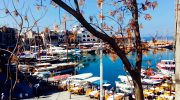
Traveling west from Larnaca, the coastal road reaches Limassol, Cyprus’s second-largest city and business center. The Medieval Castle houses the Cyprus Medieval Museum with exhibits of weapons, ceramics, and coins. The Molos waterfront promenade stretches nearly two miles with bike paths, playgrounds, and sculptures. Between Limassol and Paphos, the route passes Aphrodite’s Rock at Petra tou Romiou, where legend claims the goddess of love emerged from sea foam. The dramatic limestone formation against turquoise waters creates one of Cyprus’s most photographed locations.
The Archaeological Path Through History
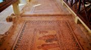
The western archaeological route connects Cyprus’s most significant ancient sites in a concentrated area. Paphos Archaeological Park contains extensive Roman mosaics from the 3rd and 4th centuries, including the Houses of Dionysus, Theseus, and Aion. These floor mosaics depict mythological scenes with remarkable detail and color preservation. The nearby Tombs of the Kings, carved from solid rock in the 4th century BC, features underground chambers and courtyards where Ptolemaic aristocrats were buried.
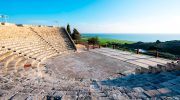
Ancient Kourion sits on a cliff 70 meters above the Mediterranean between Limassol and Paphos. The Greco-Roman amphitheater seats 3,500 spectators and still hosts theatrical performances due to exceptional acoustics. The site includes the House of Eustolios with geometric mosaics, the House of the Gladiators, and an early Christian basilica. The adjacent Sanctuary of Apollo Hylates dates to the 8th century BC, with remains of temples, baths, and sporting facilities.
Kolossi Castle stands 14 kilometers west of Limassol, a three-story Knights Hospitaller fortress from the 13th century with walls reaching 8 feet thick. The castle served as the headquarters for the production of Commandaria wine, one of the world’s oldest named wines, produced in Cyprus for over 5,000 years. The village of Omodos, 12 miles from Kolossi, contains the Holy Cross Monastery, believed to house a fragment of the True Cross and ropes that bound Christ.
The Mountain Village Circuit in Troodos
The Troodos Mountains route offers cooler temperatures and traditional village culture. The mountains cover approximately one-third of Cyprus’s area, with Mount Olympus reaching 1,952 meters. Temperatures run 18 to 27 degrees Fahrenheit cooler than the coast even during peak summer. The drive from Limassol to Troodos covers 62 miles and takes 2 to 2.5 hours.

The village circuit includes Kakopetria, spread over a hillside with traditional stone and timber architecture in its old quarter called Palia Kakopetria. The village provides access to the Karyatis waterfall and the UNESCO-listed Church of Agios Nikolaos tis Stegis from the 11th century with exceptional Byzantine frescoes. Pedoulas lies in the Marathasa Valley, built amphitheatrically on terraces. The village contains the UNESCO-listed Church of the Archangel Michael from 1474 and the imposing Church of the Holy Cross in the town center.
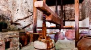
Omodos ranks as the most picturesque Troodos village, surrounded by mountains and vineyards. The village has been famous throughout history for wine production. The Timios Stavros Monastery in Omodos is among Cyprus’s oldest. The village’s main street features local tavernas, wine cellars offering tastings of indigenous grapes like Xynisteri and Maratheftiko, and traditional wine presses from medieval times.
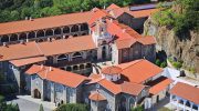
Kykkos Monastery, located 28 kilometers northwest of Troodos Village, dates to the 11th century and ranks as Cyprus’s wealthiest and most famous monastery. The monastery houses a priceless icon of the Virgin Mary, said to be painted by St. Luke. The gilded interiors, elaborate mosaics, and panoramic mountain views make this a highlight of any Troodos visit.
Natural Attractions and Scenic Routes
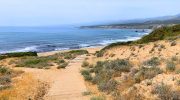
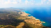
The Akamas Peninsula in northwestern Cyprus represents the island’s last significant unspoiled coastal region. This protected national park features rugged gorges, secluded sandy bays, and dense pine forests. The peninsula serves as sanctuary for endemic plants, rare butterflies, and sea turtles that nest on Lara Beach. The Blue Lagoon, with crystal-clear turquoise waters, is best accessed by boat trips from Latchi harbor. The Avakas Gorge presents a challenging route through a narrow limestone canyon carved by a river over thousands of years.
The route between Paphos and Polis passes through the Chrysoroyiatissa Monastery, founded in the 12th century by Monk Ignatios. The monastery sits in the Paphos Mountains near Panagia village and is dedicated to Our Lady of the Golden Pomegranate. Local wineries in the area offer tastings of Commandaria wine. The village of Lania, one of Cyprus’s oldest wine-making communities, features narrow lanes lined with flower-draped stone houses and the Commandaria Museum.

The coastal road from Latchi to the Baths of Aphrodite covers 15 kilometers of flat terrain suitable for cyclists and walkers. The Baths of Aphrodite, a natural grotto where legend says the goddess bathed, marks the starting point for several hiking trails into the Akamas Peninsula. Continuing west on the Akamas Trail for another 15 kilometers leads to Cape Arnauti, involving sharp descents along creeks and sand bars.
Practical Route Planning Details
Most popular routes can be completed comfortably in one to three days depending on the number of stops. The coastal circuit from Larnaca to Paphos works well as a two-day journey with an overnight stop in Limassol. The archaeological path concentrates sites close together, making it possible to visit Kourion, Kolossi Castle, and Paphos Archaeological Park in a single day. The Troodos mountain circuit requires at least two days to properly explore villages, monasteries, and natural attractions without rushing.

Car rental is essential for most routes, as public transportation serves only major cities and runs reduced schedules, particularly in winter. Buses connect coastal towns reliably, but mountain villages and archaeological sites often require private vehicles. Rental cars are readily available in Larnaca, Paphos, and Limassol airports. Left-hand traffic follows British conventions, requiring adjustment for visitors from right-hand traffic countries.
Spring and autumn provide optimal conditions for route exploration. March to June and September to November offer moderate temperatures, avoiding July and August heat that can exceed 40 degrees Celsius. Mountain areas stay cooler year-round, providing summer refuge. Winter brings rain to coastal areas and snow to Troodos, creating different challenges but also unique skiing opportunities on Mount Olympus from January to March.
How These Routes Shape Your Cyprus Experience
The travel paths around Cyprus determine what aspects of the island you encounter. Coastal routes deliver classic Mediterranean vacations with beaches, water sports, and resort amenities. Archaeological paths immerse visitors in civilizations spanning from the Bronze Age through Roman and Byzantine periods. Mountain circuits reveal traditional village life, Orthodox monasteries, and cooler forested landscapes rarely associated with Mediterranean islands. Natural routes showcase protected ecosystems, endemic species, and dramatic geological formations. These established paths allow efficient exploration while maintaining flexibility to discover personal interests. Understanding these routes before arrival helps maximize limited time and ensures experiences match individual preferences, whether prioritizing history, nature, culture, or simple relaxation.