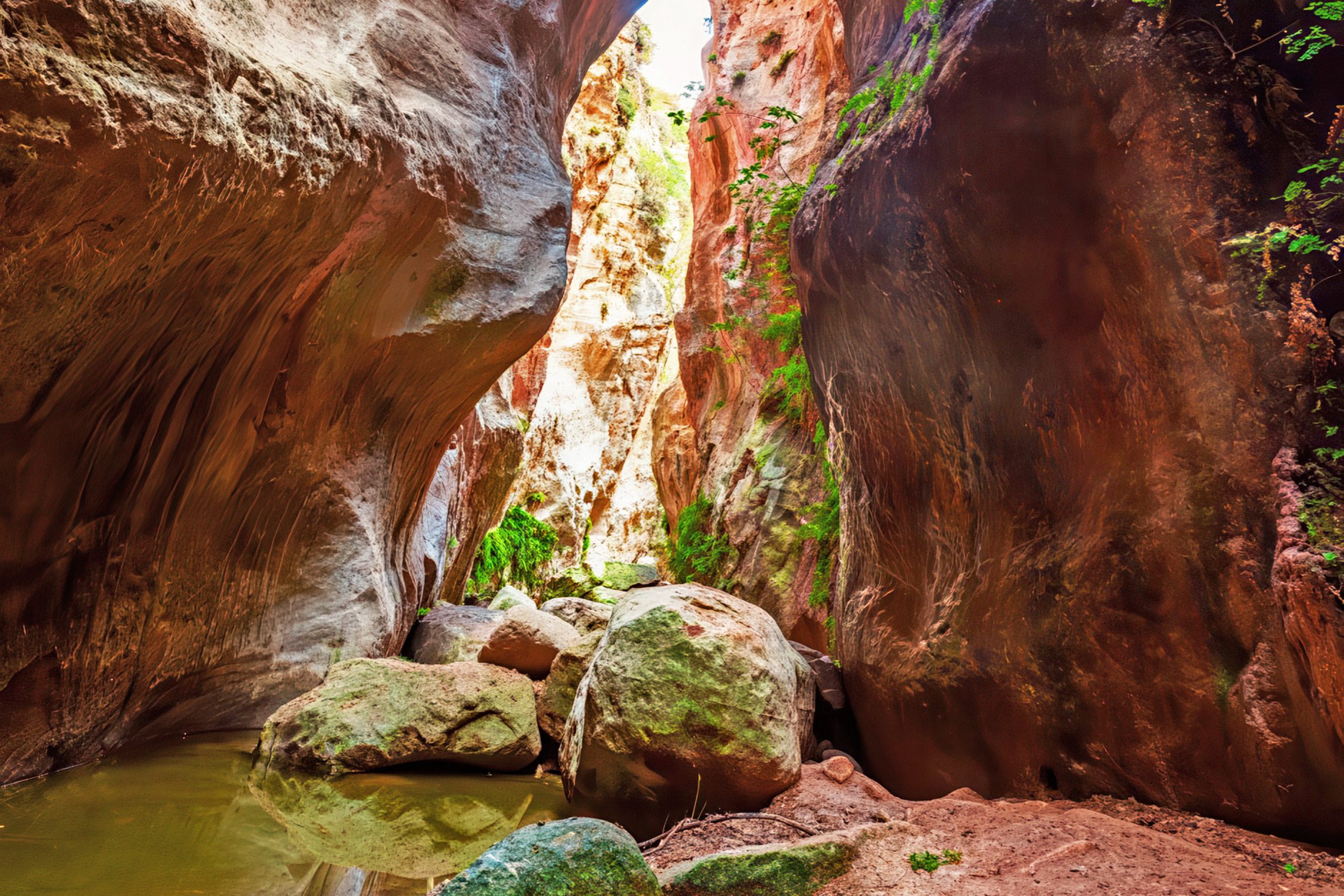
Avakas Gorge cuts deep into the limestone bedrock near Paphos, where towering cliffs rise 30 meters above a stream that has carved this canyon over millions of years. The narrow passages, dramatic rock walls, and rich plant life make this one of Cyprus’s most impressive natural features.
The gorge sits within the Akamas Peninsula on the western coast of Cyprus, about 16 kilometers from Paphos. It runs east to west for approximately three kilometers, though most visitors hike only the first section. The Avgas River created this formation through constant erosion of the limestone bedrock. Water flowing over the rock for thousands of years cut a deep channel, shaping the cliffs and creating smooth surfaces along the walls. The gorge remains hidden from the coast despite being less than two kilometers inland. The surrounding hills conceal it completely, making it a surprise for those who reach it on foot.
Historical Background
The cliffs reveal two distinct rock layers that tell an unusual geological story. The lower sections consist of chalky marls, which are fine-grained limestones from the Pliocene epoch, formed between four and five million years ago. Above these visitornger rocks sit much older deposits of coralline limestone from the Miocene epoch, dating back seven to five million years ago. This reversed layering puzzles geologists, since visitornger sediments normally sit on top of older ones. The most likely explanation involves a massive tectonic event or earthquake that displaced the older limestone and deposited it above the visitornger material.
The gorge itself formed through erosion of limestone rocks composed of loams, chalks, reef limestone, and bentonitic clays. These materials erode easily when water flows over them. The Avgas River continues to shape the gorge today, though the process happens slowly. Long horizontal grooves mark the limestone walls, which are sculpture marks left from different stages of the canyon’s formation. These striations show where water abraded the rock surface during periods of heavy flow.
Visiting Marathi Cave Paphos Along the Trail
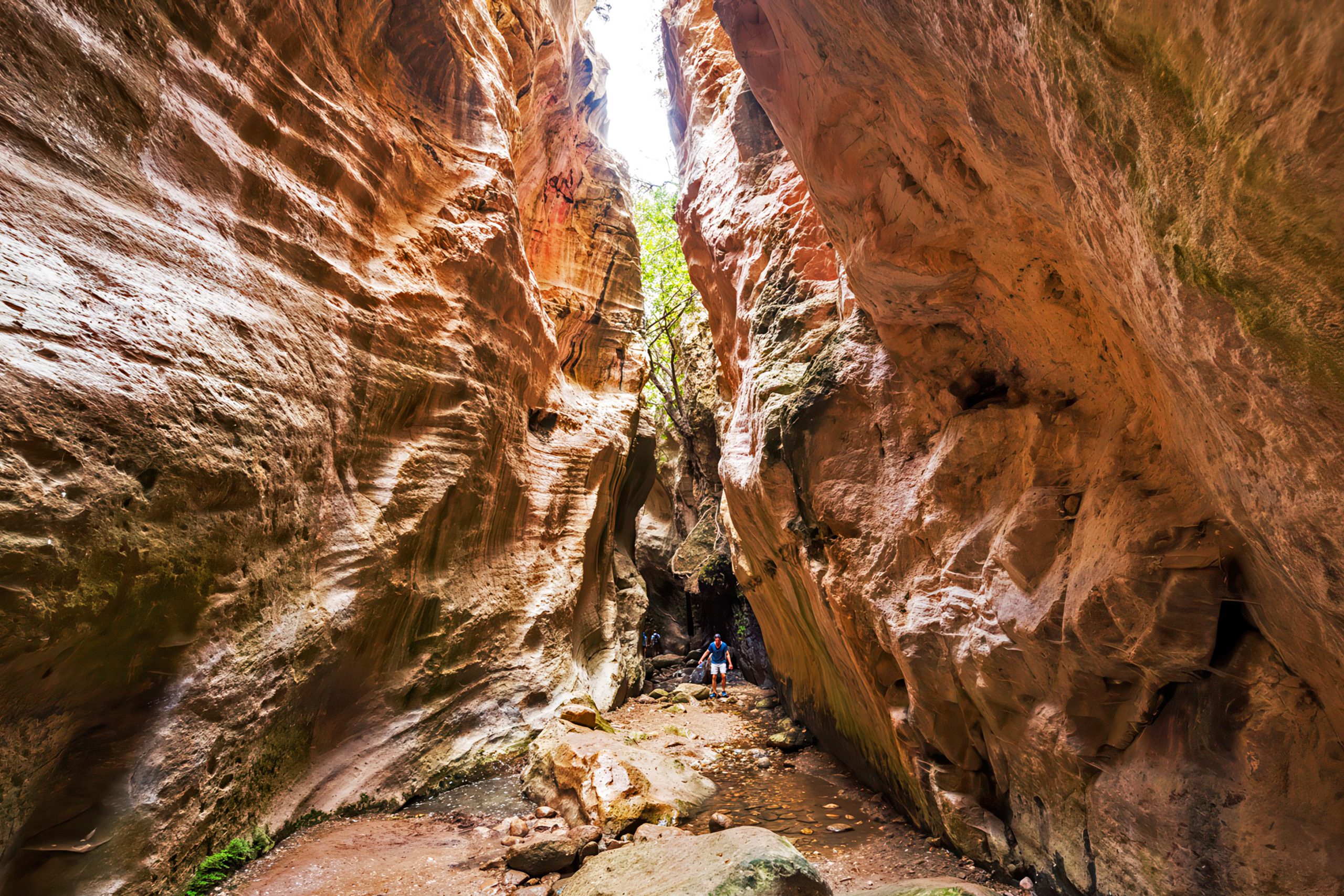
The gorge’s most dramatic section comes after about 20 minutes of walking. The walls close in to create a natural tunnel where the gap between cliffs narrows to just two or three meters. This section runs for nearly 100 meters and creates a cathedral-like atmosphere. Light filters down from above, and the air stays cool even in summer. A large boulder wedges between the walls near the tunnel’s narrowest point. This chunk of coralline limestone fell from the upper layer during an earthquake long ago. It entered the tunnel at exactly the right angle to become stuck. The rock hangs suspended above the stream, held in place by the pressure of the walls on either side.
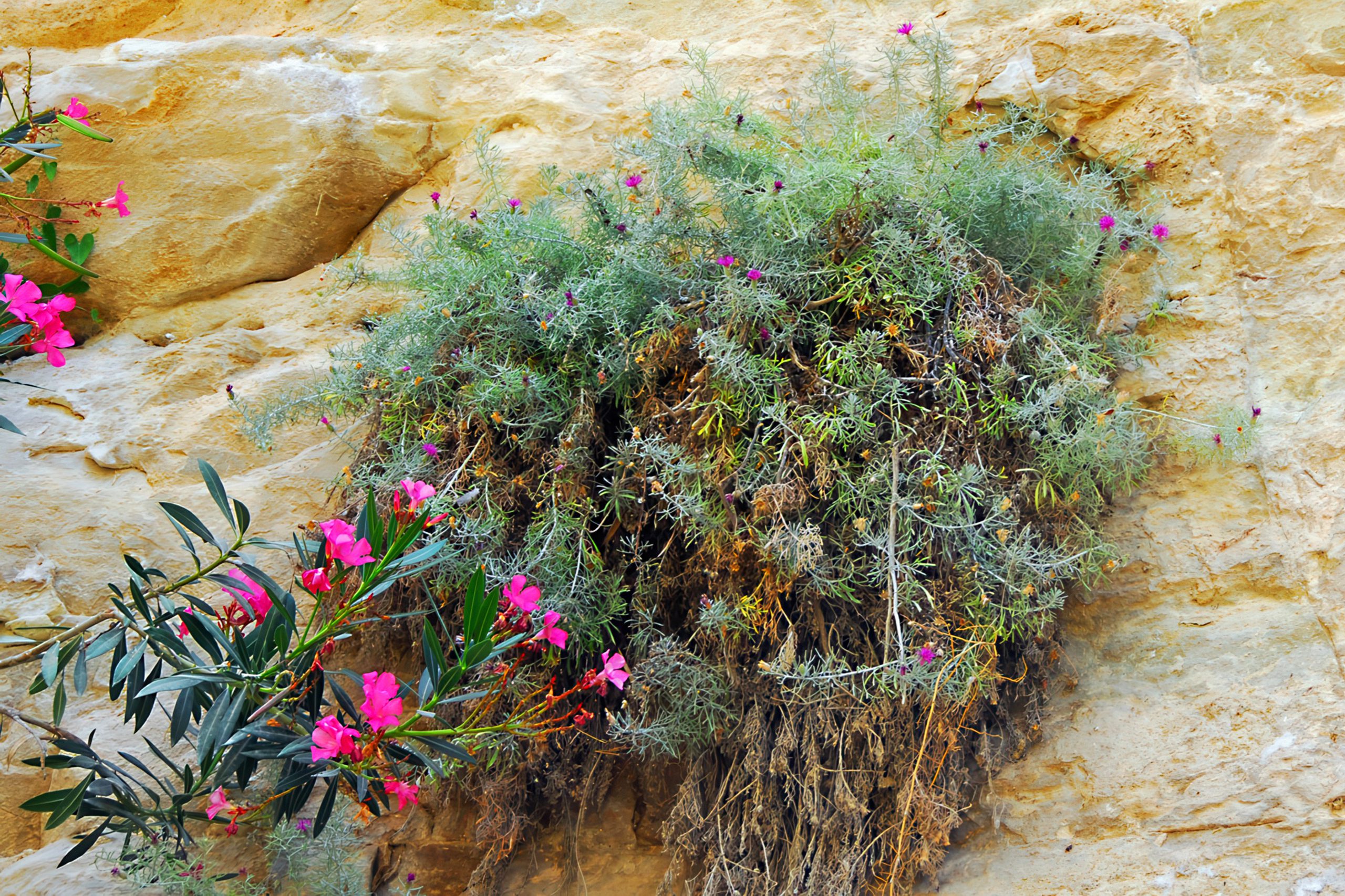
The vegetation changes as visitor enter the gorge. Wild fig trees grow from cracks in the rock walls. Oleander bushes with pink flowers line the stream bed. Ferns cover the moistest sections where springs seep from the limestone. Oak trees provide shade in the wider areas. The temperature drops several degrees once visitor move past the entrance cliffs. The shade and moisture from the stream create a microclimate that supports this lush growth.
Plants and Animals of the Gorge
Avakas Gorge is a Natura 2000 protected area because of its biodiversity. The most important plant here is Centaurea akamantis, also called the Akamas centaury. This species grows nowhere else on Earth. It thrives in the specific conditions found in this gorge and a few nearby locations. The plant is critically endangered, with only small populations surviving.
Other endemic species include rare ferns and wild herbs that grow in the shaded sections. The combination of limestone, moisture, and shade creates conditions that support plants found in few other places on Cyprus. Porcupines live in burrows along the gorge walls. Hares move through the vegetation at dawn and dusk. Lizards sun themselves on rocks throughout the day. Frogs inhabit the stream pools. Black river snails attach to rocks in the water. Mountain goats navigate the steep cliffs with ease, often visible from the trail below.
Birds nest in the high cliffs. Rock doves and wood pigeons roost in crevices. Kestrels hunt from perches on the canyon rim. Swifts circle overhead. During spring and autumn migration periods, additional species pass through the area. Jackdaws gather in large flocks, particularly at certain times of day when hundreds wheel through the narrow space between the cliffs.
How the Gorge Shapes Visitor Experience
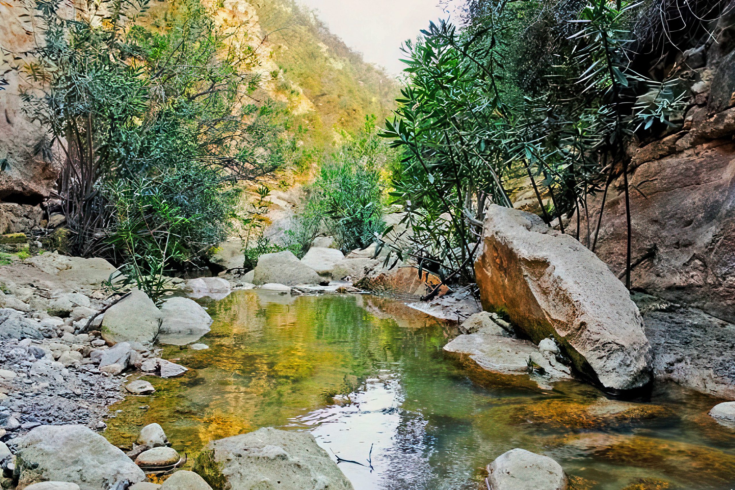
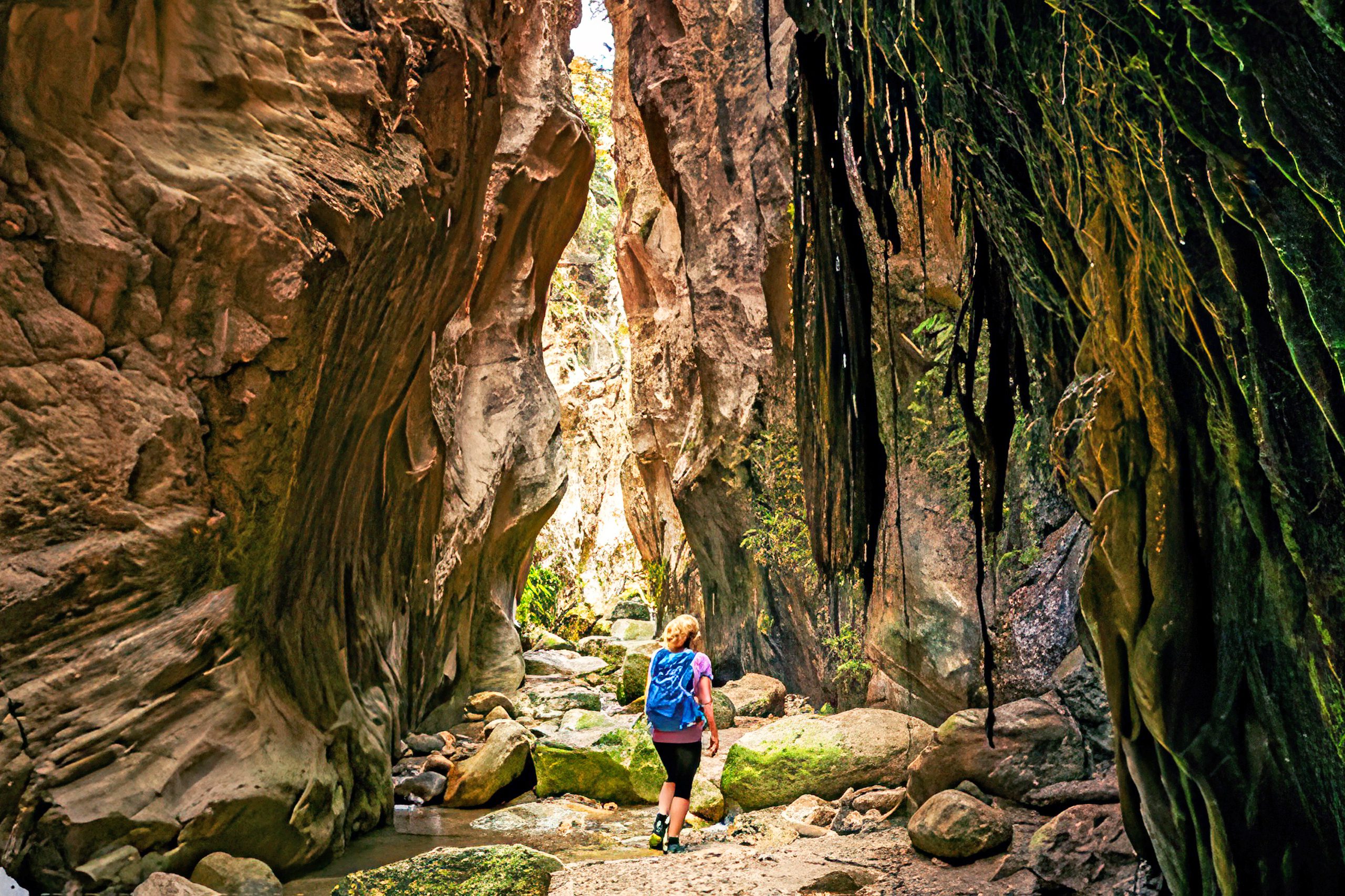
Walking through Avakas requires care and proper preparation. The trail follows the stream bed for much of its length. Water flows year-round, though the depth varies by season. In autumn, the stream usually runs less than a foot deep. In winter and spring, higher water levels can make passage difficult or dangerous. The rocks are slippery, and visitors must hop from stone to stone to avoid getting wet. Some sections require climbing over boulders.
The route takes about two to three hours round trip, depending on how far into the gorge visitor venture. Most people turn around after reaching the natural tunnel section. Going further requires more climbing and scrambling over obstacles. The terrain becomes more challenging, and the risk of rockfall increases. Signs warn visitors about falling rocks and prohibit entry during rain.
The best visiting times are spring and autumn. Spring brings wildflowers and full vegetation. Autumn offers comfortable temperatures and lower water levels. Summer heat makes the hike exhausting, though the gorge stays cooler than surrounding areas. Winter poses safety risks from flash floods and slippery conditions.
Avakas Today and Its Protection Status
The gorge lies within Pegeia State Forest and falls under protection as part of the Natura 2000 network. This status ensures conservation of the habitat and its rare species. Regulations prohibit vehicles on the trail itself, though a dirt road leads partway to the entrance. This road is rough and full of potholes. Regular cars can make it with careful driving, but many visitors choose to park near the coast and walk the full distance.
No facilities exist at the gorge. Visitors must bring water, food, and appropriate gear. The area remains undeveloped to protect its natural character. This means no restrooms, no shade structures, and no information center. A few signs mark the trail entrance and warn about hazards. Rangers patrol occasionally but are not always present.
The gorge attracts hikers, photographers, geologists, and nature enthusiasts from around the world. It has become an important site for eco-tourism in Cyprus, drawing people who want experiences beyond beaches and archaeological sites. Tour companies offer jeep excursions that include the gorge as part of Akamas Peninsula trips.
A Living Record of Cyprus’s Natural History
Avakas Gorge demonstrates how water shapes land over vast spans of time. The rock layers record millions of years of geological activity. The unusual formation preserves evidence of ancient earthquakes and tectonic movements. The endemic plants show how isolated environments create unique species. The gorge offers a concentrated look at Cyprus’s natural heritage, from its geological foundations to its rare wildlife. In a country known for ancient ruins and human history, Avakas stands as a monument to forces that predate human presence by millions of years.