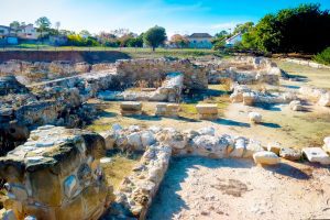
Explore Cyprus with Our Interactive Map

Explore our top stories and discover ideas worth your time.

Ayios Nikolaos Sea Cave

Ayios Nikolaos Sea Cave

Cape Greco is a headland located between Ayia Napa and Protaras at the southern end of Famagusta Bay. The area covers 385 hectares and was designated as a National Forest Park under the administration of Cyprus's Forestry Department. The coastline here features dramatic limestone cliffs that reach 30 feet (roughly 10 meters) in height and contains numerous sea caves carved by wave action. The caves are formed from layered limestone that was deposited in warm seas millions of years ago. The rock consists of hard and soft layers that erode at different rates. Waves constantly pound against the cliffs and dissolve the softer limestone faster than the harder layers above and below. This differential erosion creates the caves, arches, and tunnels that characterize the Cape Greco coastline. Historical Background The formation process began thousands of years ago when sea levels and wave patterns were different. Water enters cracks in the limestone and widens them through both mechanical force and chemical dissolution. Seawater contains salt and is slightly acidic, which helps dissolve calcium carbonate in the limestone. The caves show an almost horizontal layer of soft limestone that waves eroded easily. The overlying harder layer protected the caves from collapse and created roof structures. The lower layer is also harder and forms a several-meter-wide ledge. At some locations, this ledge is…

Read more
Cyprus Farming Rhythms and Seasonal Traditions

Cyprus Farming Rhythms and Seasonal Traditions

Cyprus agriculture follows ancient patterns shaped by Mediterranean climate and generations of farming wisdom. The island produces diverse crops throughout the year, from citrus fruits and potatoes to grapes and olives. Over 320 sunny days annually create ideal conditions for cultivation, though water scarcity challenges farmers who consume 70% of the island's resources for irrigation. Small family farms dominate the landscape despite modernization. Agriculture contributes roughly 2% to GDP while employing 7% of the workforce. The sector supports rural communities and preserves village life across mountainous terrain. Traditional methods blend with contemporary techniques as Cyprus maintains its reputation for quality Mediterranean produce. Ancient Roots Shape Modern Agriculture Farming traditions in Cyprus stretch back to the 2nd millennium BC, with archaeological evidence of olive pressing from the 13th century BC. The island cultivated grains, vines, and olive trees for millennia. Ottoman rule introduced land classifications that persisted through British colonial administration until independence in 1960. The Church of Cyprus emerged as the largest private landowner, controlling an estimated 5.8% of arable land before 1974. British authorities reformed ownership laws in 1946, allowing unrestricted private land ownership for the first time. Agricultural cooperatives formed in 1909 after farmers toured Britain and Germany, studying their systems. Today, farming faces mountainous terrain that complicates mechanical cultivation. The government promotes drought-resistant crops and wastewater treatment…

Read more
Panthea Nature Trail

Panthea Nature Trail

The Panthea Nature Trail is one of the most serene and visually spectacular hiking routes nestled within the high-elevation forests of Cyprus. Situated in the Nicosia District, the trail begins on the mountain pass between the world-famous Kykkos Monastery and the secluded village of Tsakkistra. Unlike the coastal walking paths of Cyprus, the Panthea trail immerses hikers in dense stands of pine trees, leading them along sharp ridges that offer sweeping views of the surrounding valleys. The trail serves as a physical link between isolated mountain communities, providing a peaceful escape for those looking to experience the authentic, untamed interior of the island. Panthea Nature Trail Overview Location: Road between Kykkos and Tsakkistra, Nicosia District, Western Cyprus. Distance: 10.1 kilometers (6.3 miles) for the full linear trail; there is also a popular 7.2-kilometer (4.5 miles) out-and-back variation. Route Type: Linear (can be walked one-way or out-and-back). Difficulty: Category 2 (Moderate/Difficult) due to sudden gradient changes and narrow sections. Elevation Gain: Approximately 413 meters (1,355 feet). Duration: 3 to 3.5 hours for a one-way walk, or 4+ hours for an out-and-back. Best Time to Visit: Winter and Spring (December to April) for peak visibility, cool weather, and blooming orchards. Terrain: Narrow dirt footpaths along high mountain ridgelines, transitioning to weathered gravel forest roads. The Geography and Setting of the Panthea Region…

Read more