Cyprus Hero Digenis Akritas
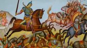
Digenis Akritas stands as the most famous epic hero to emerge from the Byzantine Empire, celebrated in folk ballads and a lengthy epic poem that originated in the 10th century and developed further in the 12th century. The name Digenis means "two-blood" or "of two peoples," referring to his mixed Byzantine Greek and Arab heritage. Akritas translates to "borderer" or "frontier guard," identifying his role defending Byzantine territory. The protagonist became the archetype of the ideal medieval Greek hero, frequently appearing in traditional folk songs particularly popular in Crete, Cyprus, and Asia Minor. For Cypriots specifically, Digenis Akritas represents more than legend, symbolizing bravery, strength, and the eternal fight for freedom against foreign invaders. The Epic Story and Family Origins The epic details the life of the hero Basil, whose epithet Digenis Akritas refers to his unique parentage. The first half of the epic, written in an epic tone, describes how his parents met. His mother, a Byzantine noblewoman named Eirene from the aristocratic Doukas family, was abducted during an Arab raid by his father, an Arab emir named Mousour. After capturing Eirene, the emir fell in love with her and she with him. To marry her, Mousour converted to Christianity, reconciling the two peoples through marriage and representing the triumph of Christianity over Islam. The reconciliation between Byzantine and…
Read more