Khirokitia (also spelled Choirokoitia) represents the peak of Cyprus’s Aceramic Neolithic period, when communities built permanent settlements without any knowledge of pottery production. The site covers approximately 3 hectares at its maximum extent and consists of circular stone and mudbrick houses clustered together on a hillside. These structures were protected by massive stone walls that enclosed the settlement on multiple sides.
The archaeological remains document a sophisticated farming society that thrived for over 1,500 years. Residents cultivated wheat and barley, raised domesticated sheep, goats, and pigs, and supplemented their diet through hunting and gathering wild foods. The settlement’s name likely derives from the Greek words for pig (χοίρος) and cradle (κοιτίς), suggesting an area where pigs were raised, though several alternative etymologies exist in local tradition.
Historical Background
Porphyrios Dikaios, director of the Department of Antiquities of Cyprus, discovered Khirokitia in 1934 during archaeological surveys for the newly established Cyprus Museum. He identified surface scatters of prehistoric material on the terraced slopes of the Maroni River valley. Between 1936 and 1946, Dikaios conducted six excavation campaigns at the site despite interruptions from World War II between 1939 and 1945.
His initial findings, published in The Journal of Hellenic Studies in 1934, first dated the settlement to around 4000 BC. However, radiocarbon dating later revealed a much earlier foundation date of approximately 7000 BC, making Khirokitia significantly older than originally believed. This placed it among the earliest permanent agricultural settlements on the island.
French archaeologist Alain Le Brun resumed excavations in 1977, leading a mission from the Centre National de la Recherche Scientifique and the French School at Athens. This long-term project continued for decades and made Khirokitia one of the most thoroughly studied Aceramic Neolithic settlements in the region. Le Brun’s team refined earlier interpretations and uncovered additional structural features, including a second enclosure wall that marked the settlement’s expansion over time.
The site was occupied from the 7th millennium BC until approximately the mid-5th millennium BC. Around 5500 BC, Khirokitia and other contemporary settlements were abandoned. Cyprus then experienced a gap of 500 to 1,000 years with no evidence of human habitation before new settlers arrived and established the later Ceramic Neolithic culture.
Architecture and Settlement Layout
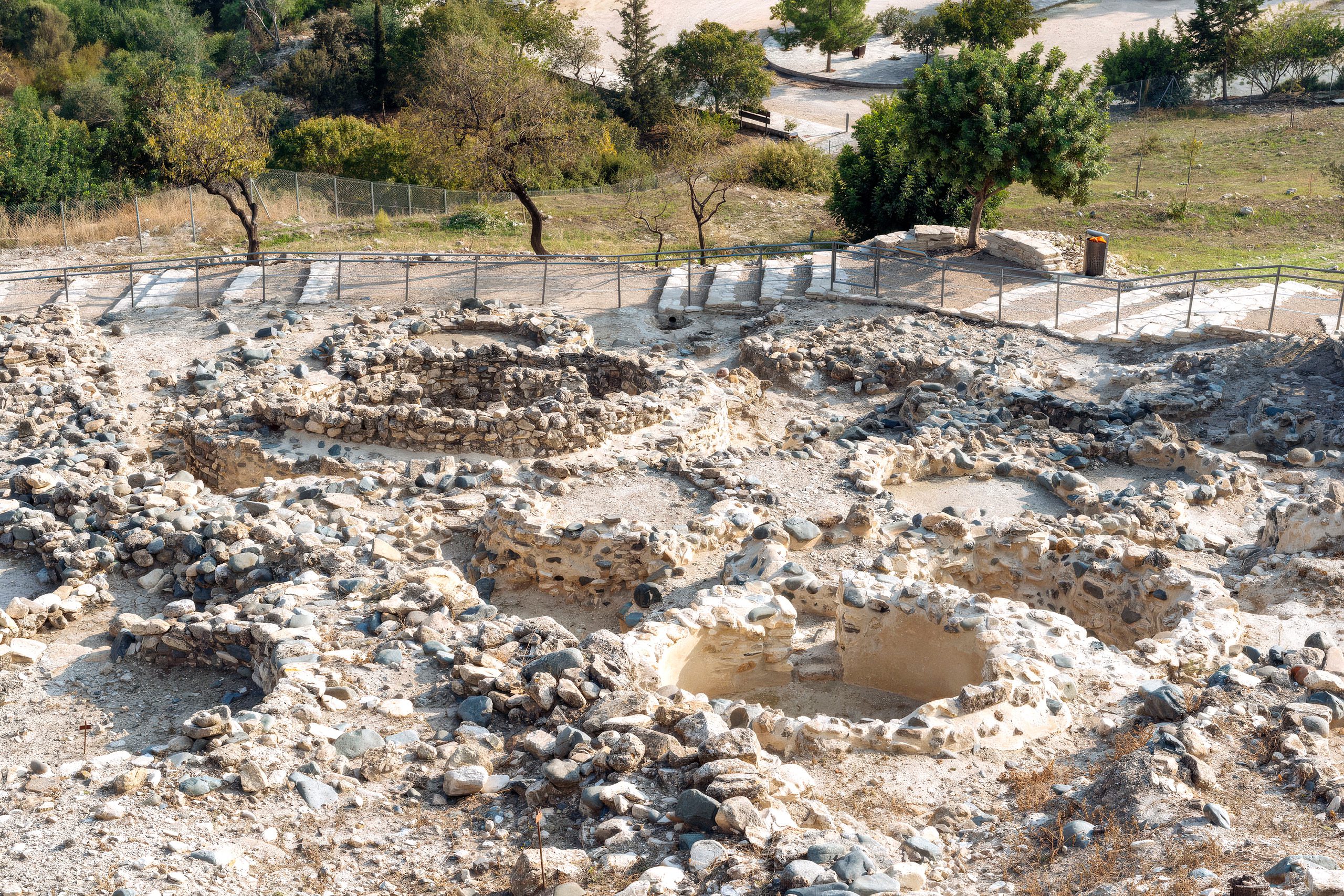
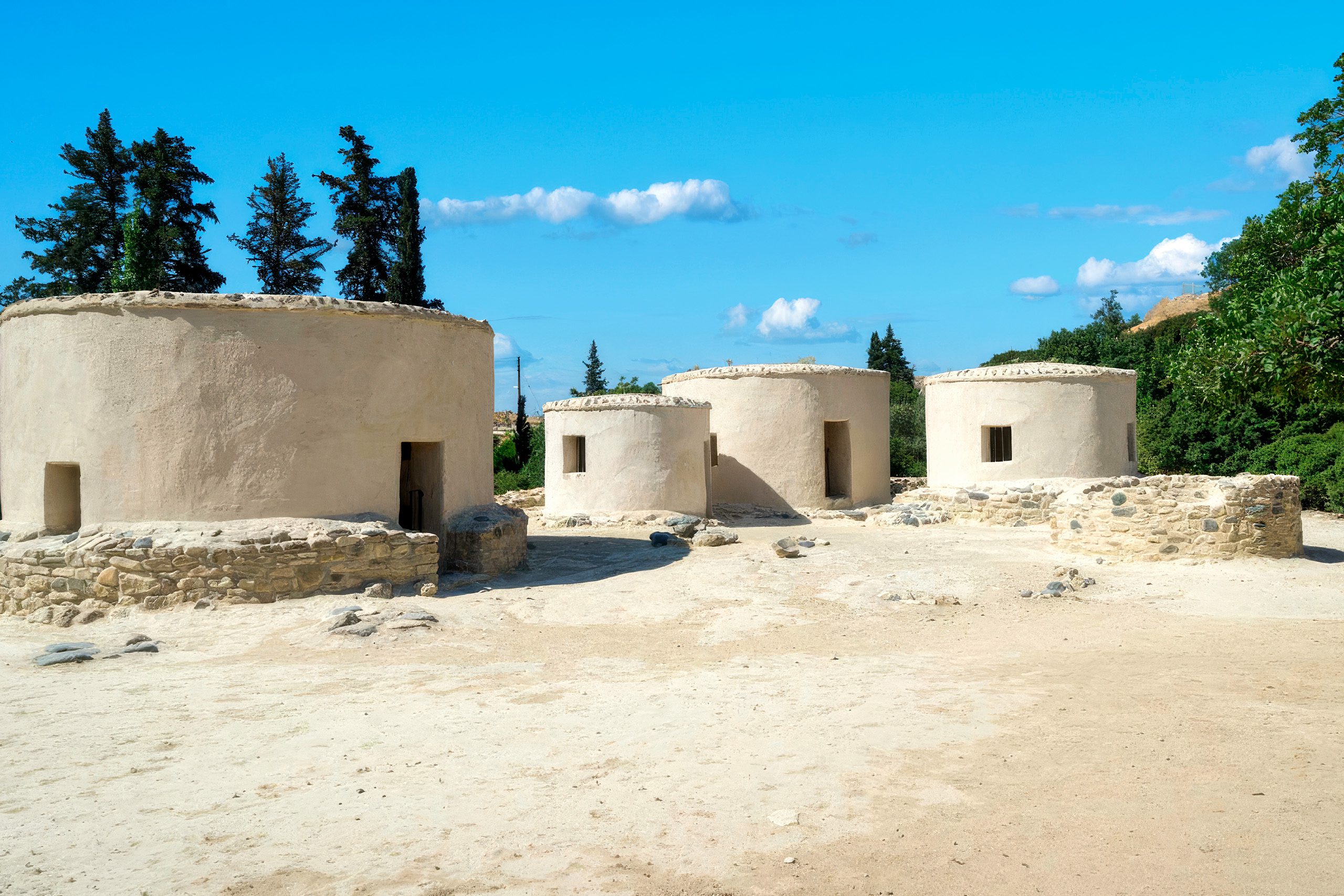
The settlement was made up of circular buildings called tholoi, which had stone foundations and mudbrick walls with flat roofs. Excavations have found about 65 of these houses, with outside diameters ranging from 2.3 to 9.8 meters. The homes were built close together, often sharing walls, and were arranged along the hillside in a tight pattern that made the most of the available space.
Inside, the houses had hearths for cooking and heating, stone benches, and windows. Many of them had piers that supported upper floors or lofts, which effectively doubled the living space. Often, several circular houses were grouped around open courtyards, forming what were likely family compounds. Based on the number and size of houses, it is estimated that Khirokitia had between 300 and 600 residents at any one time.
A large dry-stone wall made from river rocks surrounded the village. This wall was about 2.5 meters thick and reached up to 4 meters high in some areas. What Dikaios first called the “Main Road” was later identified by Le Brun as an enclosure wall marking the edge of the settlement’s first phase. A second enclosure wall in the western part of the site shows that the village expanded over time.
The walls had controlled entry points, including a narrow, winding staircase built into a large stone gateway in later phases. While the strong walls suggest the community may have needed protection from threats, there is no direct evidence of warfare or fighting. The walls probably had many purposes, including marking the community’s boundary, protecting against wild animals, and controlling access to the village.
Life in Neolithic Khirokitia
The residents of Khirokitia practiced a mixed subsistence economy. They cultivated domesticated crops, including wheat, barley, lentils, peas, horse beans, and vetch. Analysis of preserved plant remains shows they also gathered wild foods such as olives, figs, pistachios, plums, pears, and flax. Animal bones reveal they herded sheep, goats, and pigs while also hunting deer.
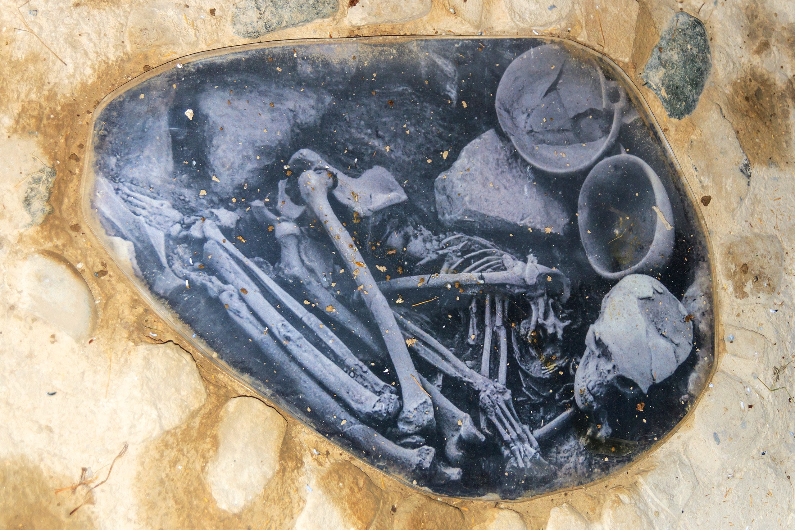
The people of Khirokitia were relatively short by modern standards. Adult men averaged about 160 centimeters (5 feet 3 inches) in height while women averaged about 150 centimeters (4 feet 11 inches). Life expectancy was approximately 33 to 35 years for adults who survived childhood. Skeletal remains show signs of physical stress from subsistence activities but no clear evidence of violence or ritual sacrifice.
The dead were buried within the settlement in flexed positions beneath house floors or in spaces between buildings. This practice of intramural burial indicates strong bonds between the living and their ancestors. Graves sometimes contained offerings including stone bowls, bone tools, shell ornaments, and red ochre sprinkled over the body. The presence of grave goods suggests beliefs about an afterlife or practices of ancestor veneration.
The Khirokitia Culture
The settlement was so important that archaeologists named an entire cultural period after it. The Khirokitia culture represents the Late Aceramic Neolithic in Cyprus, lasting from around 7000 BC to 5200 BC. This period of about 1,500 years marks the high point of Cyprus’s Pre-Pottery Neolithic tradition.
Around 20 similar settlements from this time have been found across Cyprus, but Khirokitia is the largest and best-preserved. The similarities in house designs, burial practices, and objects at these sites show that people across the island shared common traditions during this period.
The Khirokitia culture developed its own unique style, rather than just copying the cultures of the Near Eastern mainland. Even though Cyprus was close to the Levant and Anatolia and shared similar climate and environment, communities on the island created their own ways of living and adapted their Neolithic life to the specific conditions of Cyprus.
Khirokitia’s Place in Cypriot History
The settlement is one of the earliest successful farming communities on Cyprus, founded by people who came from the Near East around the beginning of the 9th millennium BC. These early settlers brought knowledge of farming and animal raising, which changed the island from a place occasionally visited by hunters into a land with permanent villages.
The careful planning seen in Khirokitia shows a high level of teamwork and organization. The big enclosure walls and well-arranged layout of the village required everyone to work together, something that few contemporary sites in the Near East could match. This level of cooperation allowed the community to build large structures for the common benefit.
After more than 1,000 years of thriving, Khirokitia was abandoned around 5500 BC, though the reasons are still debated. Possible explanations include environmental problems, population decline, disease, or social changes that made people adopt a less settled lifestyle. After Khirokitia and similar sites were left, Cyprus seems to have been mostly uninhabited for several centuries before new settlers arrived and started the Ceramic Neolithic culture.
The Site Today and Reconstruction Efforts
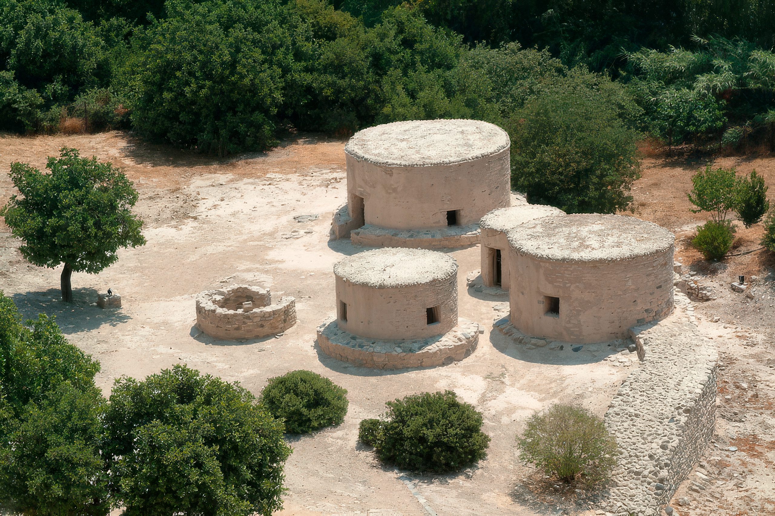
The archaeological site is open to visitors year-round except for major holidays. Five characteristic cylindrical dwellings have been reconstructed near the original settlement using the same construction methods and materials employed in Neolithic times. These reconstructions are furnished with replicas of household objects found in the original dwellings.
The site has been developed for tourism in a low-key manner that respects its archaeological integrity. Two protective coverings shelter excavated areas near the summit of the hill, but otherwise the ruins remain exposed to view. Interpretive signs explain the settlement’s features and history. A visitor center provides additional context and displays artifacts recovered during excavations.
The site’s location makes it easily accessible. Khirokitia is 31 kilometers from Larnaca, 50 kilometers from Nicosia, and 100 kilometers from Paphos. Bus service connects the site to major cities, though visiting by car offers more flexibility. The combination of original ruins and reconstructed buildings provides both archaeological authenticity and educational accessibility.
Why Khirokitia Matters to World Heritage
Khirokitia’s UNESCO World Heritage designation in 1998 recognized its outstanding universal value in illustrating cultural exchanges between Asia and the Mediterranean during a crucial period of human development. The site provides irreplaceable evidence about how early farming societies organized themselves, constructed permanent settlements, and developed social institutions.
The exceptional preservation quality means most of the site remains unexcavated, forming an archaeological reserve for future generations of researchers equipped with more advanced investigative techniques. This untapped potential ensures Khirokitia will continue contributing to our understanding of Neolithic life for decades to come.