Explore Cyprus with Our Interactive Map

Explore our top stories and discover ideas worth your time.

Karpasia Peninsula Route Cyprus

Karpasia Peninsula Route Cyprus

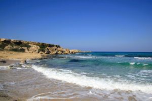
The Karpasia Peninsula extends like a long finger into the Mediterranean from northeastern Cyprus, reaching 75 kilometers toward Turkey and Syria. This narrow landmass, also known as the Panhandle, represents Cyprus's most remote and undeveloped region. The peninsula covers 898 square kilometers with a population density of just 26 people per square kilometer, making it one of the least inhabited parts of the island. google-com The main route runs from Trikomo, considered the gateway town, through small villages to Cape Apostolos Andreas at the very tip. This wild coastline hosts more than 46 sandy beaches, ancient ruins, and rare wildlife that make the journey one of Cyprus's most rewarding drives. Historical Background The Karpasia Peninsula has supported human settlement since the Late Bronze Age, with archaeological evidence showing continuous habitation for over 3,000 years. Ancient harbor sites near where Hala Sultan Tekke stands today served the town of Kition during its Bronze Age prominence from 1650 to 1050 BC. These coastal areas functioned as crucial trading posts connecting Africa, Asia, and Europe through maritime networks. The ancient city of Karpasia gave the peninsula its name, though only ruins remain today near the modern village of Rizokarpaso. Another major Bronze Age settlement, Afendrika, lies about seven kilometers east of Agios Filon Beach. This city flourished during the second century BC and…

Read more
Mesaoria Plain Cyprus Agricultural Heartland

Mesaoria Plain Cyprus Agricultural Heartland

The Mesaoria Plain stretches 96 kilometres across central Cyprus between two mountain ranges. Mesaoria, meaning "between the mountains" in Greek, is a broad central plain that extends from Morphou Bay in the west to Famagusta Bay in the east. The Troodos Mountains rise to the south, while the Kyrenia Range forms a wall to the north. The plain covers approximately 1,000 square kilometres with elevations ranging from 100 metres on average up to 325 metres at its highest points. wikimedia-org Nicosia, the capital of Cyprus, sits roughly in the centre of the plain along the Pedieos River. This positioning reflects centuries of strategic thinking, as the location provided access to both coasts. The plain contains dozens of villages and several major towns, making it the most densely populated region on the island despite its harsh summer climate and winter-dependent water supply. Historical Background Twenty million years ago, Cyprus existed as two separate islands corresponding to what would become the Kyrenia and Troodos mountain ranges. Approximately one million years ago, tectonic forces pushed up the land between these islands, creating the Mesaoria Plain and joining them into the single landmass known today as Cyprus. The Mediterranean Sea covered and exposed the plain multiple times as sea levels changed, but it has remained in its current form since the end of the…

Read more
Kaledonia Waterfall Trail

Kaledonia Waterfall Trail

The Kaledonia Waterfall Trail offers one of Cyprus's most scenic forest hikes. This 3-kilometer nature trail follows the Kryos Potamos River through dense pine and oak forests in the Troodos Mountains, leading to a spectacular 12-meter waterfall at 1,330 meters elevation. chooseyourcyprus-com The trail takes its name from the Kaledonia waterfall at its center point, though many maps also spell it Caledonia. The path maintains a mostly shaded route under tall pine trees along the riverbank, creating a cool microclimate even during Cyprus's hot summer months. The sound of rushing water accompanies hikers throughout the journey as they cross the Kryos Potamos River six to seven times before reaching the main cascade. The trail sits within Troodos National Forest Park, a protected area covering 9,147 hectares around Mount Olympus. Wooden bridges span the stream at key points, though hikers must also step across river stones polished smooth by centuries of water flow. Business Insider ranked this waterfall as the 14th best in Europe in 2015, bringing increased international attention to what was previously a lesser-known local hiking destination. Historical Background In 1878, a Scottish expedition visited the Platres region during the early period of British colonial administration in Cyprus. When the Scots encountered the waterfall and surrounding landscape, they found remarkable similarities to the waterfalls and forested gorges of their…

Read more