Explore Cyprus with Our Interactive Map

Explore our top stories and discover ideas worth your time.

British Police Stations

British Police Stations

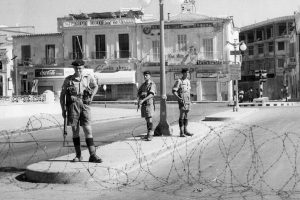
British Police Stations and Administrative Offices in Cyprus represent the architectural and institutional backbone of colonial rule, embodying the empire's strategies for maintaining order, surveillance, and administrative dominance over the island from 1878 to 1960. Constructed during the British administration, these structures blended Victorian functionality with local adaptations, serving as symbols of imperial authority while facilitating the enforcement of laws, collection of intelligence, and governance of a diverse population. Key examples include the Larnaca Police Headquarters, district administrative buildings in Limassol and Famagusta, and central offices in Nicosia, which housed colonial bureaucrats and police forces. These edifices not only projected power through their imposing designs but also became sites of resistance during the Cyprus Emergency, where they were targeted by nationalists seeking independence. Today, many survive as museums, government offices, or repurposed spaces, reminding Cypriots of a era marked by control and contestation, and highlighting the island's transition from colony to republic amid ongoing debates on heritage and identity. dom-com A Network of Colonial Control British Police Stations and Administrative Offices formed an extensive network across Cyprus, strategically placed in urban centers and rural districts to ensure surveillance and swift response to unrest. In Nicosia, the colonial secretariat and government house anchored the administrative hub, while police stations in Larnaca, Limassol, Paphos, and Famagusta extended control to coastal and inland…

Read more
Pinus Brutia

Pinus Brutia

Imagine stepping onto sun-drenched slopes where tall evergreens sway in the breeze, their long needles catching golden light and filling the air with a fresh, resinous scent. This is the world of Pinus brutia, Cyprus’s most iconic pine and the backbone of the island’s woodlands. Together with its mountain cousin, it reveals a story of ancient resilience that still thrives across the Mediterranean landscape today. www.inaturalist.org A Pine Built for the Island Pinus brutia, commonly known as the Calabrian pine, is a hardy evergreen conifer perfectly suited to the warm, dry conditions of the eastern Mediterranean. In the broad pine family (Pinaceae), it stands out for its fire-adapted seeds and drought tolerance. On Cyprus it reigns supreme, forming the vast majority of the island’s forests from sea level right up to the cooler heights where its relative, the black pine (Pinus nigra ssp. pallasiana), takes over. The Aleppo pine (Pinus halepensis) also appears, sometimes as a planted companion or in transitional zones. Echoes of Ancient Forests In 1881, French forester P.G. Madon climbed Mount Troodos and described a Cyprus once cloaked in “vast forests… pines of different species in dense profusion” mingling with cedar, oak and cypress down to the plains. For millennia these trees supplied timber for Phoenician mines, Ptolemaic fleets, Lusignan palaces and Venetian ships. Yet centuries of…

Read more
Cyprus Fertile River Valleys

Cyprus Fertile River Valleys

Cyprus contains approximately 35 streams and rivers, though most qualify as temporary watercourses that flow only during winter rains. These rivers create fertile valleys that have supported agricultural communities for over 9,000 years. The island receives an estimated 600 million cubic meters of usable runoff from annual rainfall, a limited resource distributed unevenly across the landscape. Major rivers, including the Pedieos, Kouris, Xeros, Vasilikos, and Diarizos originate in the Troodos Mountains, flow through productive valleys, and terminate either at the Mediterranean coast or in modern reservoir systems. theislandofcyprus.com The Pedieos River Valley and Central Plains Agriculture The Pedieos River extends 100 kilometers from its source near Machairas Monastery in the Troodos range, making it the longest river in Cyprus. The river flows northeast through the Mesaoria Plain, passes through Nicosia, and then continues east to Famagusta Bay near the ancient city of Salamis. Archaeological evidence confirms continuous agricultural settlement along the Pedieos valley from the Bronze Age through modern times. The ancient town of Tamasos developed on the left bank of the Pedieos, its ruins extending across a hill overlooking the rich valley below. wikipedia.org The river derives its name from ancient Greek words meaning to see the east, as its course coincides with the path of the dawn goddess. The Mesaoria Plain, traversed by the Pedieos and several tributary…

Read more