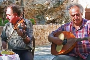
Explore Cyprus with Our Interactive Map

Explore our top stories and discover ideas worth your time.

Venetian Bridges Nature Trail

Venetian Bridges Nature Trail

The Paphos Forest hides a secret world where history meets the wild. You walk on trails that medieval merchants once used to transport copper and gold. These paths connect three spectacular stone structures known as the Venetian Bridges. Deep valleys and thick cedar trees create a quiet atmosphere for every visitor. The air feels cool even when the sun shines bright above the canopy. You hear the sound of water as it flows under old arches. This journey offers a glimpse into the past of Cyprus. It remains a top choice for those who love quiet walks. Every step reveals a new view of the green landscape. Trail Overview Location: Paphos Forest, Limassol/Paphos District, Cyprus Distance: 17 km (Full linear trail) Route Type: Point-to-Point (Linear) Difficulty: Moderate Elevation Gain: 600 meters Duration: 5 – 6 hours Best Time to Visit: March to June or September to November Terrain: Dirt tracks, forest paths, and rocky slopes The Historical Significance of the Venetian Bridges The Venetian era in Cyprus left a permanent mark on the island. Engineers built these bridges during the 16th century to facilitate trade between mountain mines and the coast. Mules carried heavy loads across these stone spans every day. The architecture reflects a need for strength and durability against mountain floods. You see precise stonework that survives centuries…

Read more
Cyprus Fertile River Valleys

Cyprus Fertile River Valleys

Cyprus contains approximately 35 streams and rivers, though most qualify as temporary watercourses that flow only during winter rains. These rivers create fertile valleys that have supported agricultural communities for over 9,000 years. The island receives an estimated 600 million cubic meters of usable runoff from annual rainfall, a limited resource distributed unevenly across the landscape. Major rivers, including the Pedieos, Kouris, Xeros, Vasilikos, and Diarizos originate in the Troodos Mountains, flow through productive valleys, and terminate either at the Mediterranean coast or in modern reservoir systems. The Pedieos River Valley and Central Plains Agriculture The Pedieos River extends 100 kilometers from its source near Machairas Monastery in the Troodos range, making it the longest river in Cyprus. The river flows northeast through the Mesaoria Plain, passes through Nicosia, and then continues east to Famagusta Bay near the ancient city of Salamis. Archaeological evidence confirms continuous agricultural settlement along the Pedieos valley from the Bronze Age through modern times. The ancient town of Tamasos developed on the left bank of the Pedieos, its ruins extending across a hill overlooking the rich valley below. The river derives its name from ancient Greek words meaning to see the east, as its course coincides with the path of the dawn goddess. The Mesaoria Plain, traversed by the Pedieos and several tributary floodplains, once…

Read more
Choirokoitia Settlement

Choirokoitia Settlement

Choirokoitia Settlement is a remarkable Neolithic village on Cyprus's southern coast, dating back to around 7000 BC, where early humans first built permanent homes and formed communities. Recognized as the most important site of its kind in the eastern Mediterranean, it reveals how people shifted from wandering hunters to settled farmers, laying foundations for civilization. This ancient spot whispers stories of innovation and survival, sparking interest in humanity's shared journey toward organized life. turbinatravels-com A Window into Early Human Life Choirokoitia stands as one of the earliest and best-preserved examples of a settled Neolithic community in the region, offering a detailed look at the transition from nomadic existence to village life. Located in the Larnaca District on a hillside overlooking the Maroni River Valley, the site's strategic position provided natural defenses, access to water, and fertile soil for early agriculture. Spanning about 3 hectares, it housed up to 300 people in circular dwellings, marking a pivotal shift in human history known as the Neolithic Revolution. This change involved domesticating plants like emmer wheat, barley, lentils, and animals such as sheep, goats, and pigs, which were introduced to the island by the first settlers from the Levantine mainland around 8500 BC. topwar-ru The settlement's layout reflects emerging social organization, with houses clustered in a semi-circular pattern around a central open space,…

Read more