Trahanas Preserving In Cyprus
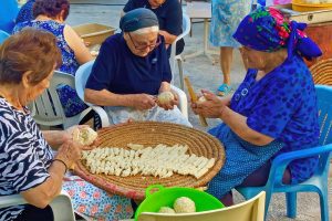
Trahanas is not a soup in the usual sense. It is a solution shaped by necessity. Long before refrigeration, electricity, or supermarkets, Cypriot households needed a way to preserve the abundance of summer milk and turn it into nourishment for the colder, damp months that followed. Trahanas emerged as a practical answer to this challenge, turning perishable ingredients into a stable, nourishing reserve. Tangy, filling, and deeply comforting, trahanas sits at the centre of Cyprus’s food memory not because it is impressive, but because it worked when it mattered most. To eat trahanas is to taste the logic of survival shaped by land, climate, and patience. A Food Designed to Last, Not Impress At its core, trahanas is made from sour sheep’s or goat’s milk combined with cracked wheat, often called konari in Cyprus. The mixture is fermented, cooked, shaped, and then dried under the summer sun until it becomes hard and shelf-stable. Months later, it is rehydrated with water or stock and slowly boiled into a thick, warming soup. This transformation is the point. Trahanas begins as liquid, becomes solid, and returns to liquid again, with every stage designed to extend life rather than enhance appearance. The rough texture, the sourness, and the muted colour are not flaws. They are evidence of a food designed with intention, where practicality…
Read more