Explore Cyprus with Our Interactive Map

Explore our top stories and discover ideas worth your time.

Cyprus Volcanic Rocks

Cyprus Volcanic Rocks

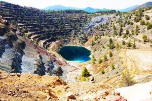
Cyprus holds a unique position in geological science. The island contains Earth's best preserved ophiolite complex, a rare slice of ancient oceanic crust and upper mantle thrust upward onto land. This exceptional geological heritage shaped both the island's dramatic landscapes and its human history, particularly through copper deposits that gave Cyprus its very name. The Troodos Massif formed 90 million years ago during the Upper Cretaceous period at the bottom of the ancient Tethys Ocean. The rocks visible today once existed 8,000 meters below sea level at a mid-ocean ridge spreading center, where new oceanic crust continuously forms as tectonic plates pull apart. Geologists call this complete sequence an ophiolite complex. Troodos was not metamorphosed during uplift, allowing scientists to study pristine oceanic rocks without submarines. This makes Cyprus an on-land analogue for modern mid-ocean ridges. The collision of African and Eurasian tectonic plates pushed the oceanic lithosphere upward rather than downward into a trench. Troodos first rose above sea level about 20 million years ago, with uplift centered around Mount Olympus at 1,952 meters. Erosion exposed deeper layers, allowing visitors to walk from rocks that once existed in Earth's mantle to rocks that formed at the ancient seafloor. Complete Rock Sequence from Mantle to Seafloor The ophiolite exposes a perfect vertical sequence. At the deepest level lie mantle rocks…

Read more
Ayia Napa Lover’s Bridge

Ayia Napa Lover’s Bridge

The Lover's Bridge stands as one of Cyprus's most photographed natural landmarks. This limestone arch extends from the coastal cliffs near Ayia Napa, reaching toward the Mediterranean Sea with one end firmly anchored to land while the other dips into crystal-clear turquoise water. The bridge measures approximately 6 meters long and half a meter wide, formed entirely through natural processes without any human construction. Visitors from around the world come to walk across this slender natural formation, particularly during sunset hours when golden light transforms the white limestone and azure water into a scene of remarkable beauty. The bridge takes its name from romantic traditions that have developed around the site. Local legend claims that couples who kiss while standing in the middle of the arch and make a wish together will see their wishes come true. This belief has made the location a popular destination for marriage proposals, wedding photographs, and symbolic ceremonies celebrating love and commitment. How Wave Action Sculpted the Arch The Lover's Bridge formed through a combination of mechanical and chemical erosion acting on limestone bedrock. Rainwater absorbs carbon dioxide from the atmosphere and soil, creating a weak carbonic acid solution. When this slightly acidic water contacts limestone, it triggers chemical reactions that gradually dissolve the calcium carbonate rock. Seawater contains additional dissolved salts and compounds…

Read more
Toumba tou Skourou

Toumba tou Skourou

Near the town of Morphou in northwestern Cyprus, an artificial hill once rose from the fertile plain where the Ovgos River flows toward the sea. For over 600 years during the Bronze Age, this spot was home to potters who made beautiful ceramics, copper workers who processed metal from nearby mines, and families who buried their dead in tombs cut into the rock. Bulldozers destroyed much of the site before archaeologists could study it, but what they found in three short years changed how we understand Bronze Age Cyprus. Historical Background Toumba tou Skourou was a Late Bronze Age settlement and cemetery located 4 kilometers from central Morphou on Cyprus's northwestern coast. The name means "Mound of Darkness" in Greek, though scholars debate where this unusual name came from. The site consisted of an artificial mound about 10 meters high, 12 meters wide, and 20 meters long, created from the accumulated debris of centuries of human activity. The settlement flourished from the Middle Bronze Age through the Iron Age, roughly 1650 BC to 750 BC. During its peak, Toumba tou Skourou functioned as an industrial center where craftspeople made pottery and processed copper from mines in the nearby Troodos Mountains. The site also contained residential areas, storage buildings with large pithoi (clay jars), and at least six chamber tombs with…

Read more