Cyprus Traditional Dance Competitions
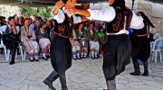
Traditional dance competitions in Cyprus are not performances staged for spectacle alone. They are structured moments where history, regional identity, and communal memory are actively tested and refined. Across village squares, coastal towns, and formal festival stages, dancers are judged not only on technique but on how faithfully they carry movements shaped by centuries of Cypriot life. What emerges is not nostalgia, but discipline. Not a postcard version of tradition, but a living standard that Cyprus expects its dancers to meet. More Than Dance: Why Competition Matters in Cyprus In Cyprus, dance has never been separate from daily life. For generations, it accompanied weddings, harvests, religious festivals, and seasonal gatherings. Competition emerged naturally from this environment, not as rivalry for its own sake, but as a way of recognising skill, confidence, and social standing. Modern competitions continue that older logic. They exist to ensure that dances are not diluted by convenience or modern taste. Judges evaluate how well performers understand structure, rhythm, posture, and cultural intent. Winning matters, of course, but correctness matters more. To dance well in Cyprus is to show that you know where the movement comes from and why it exists. A Shared Language with Regional Accents Cypriot folk dance operates on two levels at once. There is an island-wide vocabulary of steps and formations that most…
Read more