Explore Cyprus with Our Interactive Map

Explore our top stories and discover ideas worth your time.

Bishop Epiphanius of Salamis

Bishop Epiphanius of Salamis

Epiphanius of Salamis stands as one of the most learned figures of the early Christian church. Born between 310 and 320 AD near Eleutheropolis in Palestine, he came from a Jewish background and converted to Christianity in his youth. ai-generated The event that sparked his conversion was witnessing a monk named Lucian give away his clothing to a poor person. This act of compassion moved Epiphanius to seek instruction in the Christian faith, setting him on a path that would make him one of the most influential church leaders of the fourth century. After his conversion, Epiphanius joined a monastery in Egypt where he studied under the guidance of Saint Hilarion the Great. His time in Egypt proved formative, exposing him to various religious movements and teaching him the monastic discipline that would shape his entire life. He returned to Palestine around 333 AD and founded his own monastery near his birthplace, where he served as abbot for approximately thirty years before being called to higher service. From Monastery to Metropolitan During his three decades as a monastery superior, Epiphanius gained an extraordinary reputation for scholarship and ascetic discipline. He mastered an impressive array of languages, including Hebrew, Syriac, Egyptian, Greek, and Latin. This linguistic skill earned him the nickname "Pentaglossos" or "Five-tongued" from his contemporary Jerome. His ability to…

Read more
Governor’s Beach, Cyprus

Governor’s Beach, Cyprus

Governor's Beach is actually two connected beaches near Pentakomo village, about ten kilometers east of Limassol. The main section features dark volcanic sand framed by striking white chalk cliffs, while the neighboring Kalymnos beach extends as a narrow sandy strip approximately 200 meters to the west. tripadvisor.com Together they form a two-kilometer coastline recognized for exceptional water quality and environmental standards. The area sits roughly 40 kilometers west of Larnaca and 30 kilometers east of Limassol, positioned far enough from major tourist strips to maintain a more peaceful character. Historical Background The beach earned its name during British colonial rule when high-ranking officials chose this location for recreational activities. The striking white cliffs and gray sand apparently reminded them of the Dover coastline back home. A British governor maintained a summer residence nearby in Maroni village, though he frequently visited this particular stretch of coast. The first president of independent Cyprus, Archbishop Makarios III, also enjoyed the former colonial cottage, which still stands today awaiting government decisions about its future use. sandee.com The western section carries the name Kalymnos after professional sponge divers from the Greek island of Kalymnos who berthed their ships in this bay during the late 19th and early 20th centuries. These divers harvested natural sea sponges until overexploitation and disease destroyed the sponge fields throughout the…

Read more
Toumba tou Skourou Bronze Age Burial Site

Toumba tou Skourou Bronze Age Burial Site

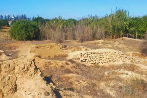
Near the town of Morphou in northwestern Cyprus, an artificial hill once rose from the fertile plain where the Ovgos River flows toward the sea. For over 600 years during the Bronze Age, this spot was home to potters who made beautiful ceramics, copper workers who processed metal from nearby mines, and families who buried their dead in tombs cut into the rock. Bulldozers destroyed much of the site before archaeologists could study it, but what they found in three short years changed how we understand Bronze Age Cyprus. visitcyprus-com Historical Background Toumba tou Skourou was a Late Bronze Age settlement and cemetery located 4 kilometers from central Morphou on Cyprus's northwestern coast. The name means "Mound of Darkness" in Greek, though scholars debate where this unusual name came from. The site consisted of an artificial mound about 10 meters high, 12 meters wide, and 20 meters long, created from the accumulated debris of centuries of human activity. wikimedia-org The settlement flourished from the Middle Bronze Age through the Iron Age, roughly 1650 BC to 750 BC. During its peak, Toumba tou Skourou functioned as an industrial center where craftspeople made pottery and processed copper from mines in the nearby Troodos Mountains. The site also contained residential areas, storage buildings with large pithoi (clay jars), and at least six chamber…

Read more