Explore Cyprus with Our Interactive Map

Explore our top stories and discover ideas worth your time.

Cyprus Woodland Areas Pine Cedar Dominance

Cyprus Woodland Areas Pine Cedar Dominance

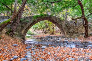
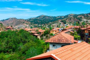
Cyprus stands as the third-largest island in the Mediterranean Sea, covering 9,251 square kilometers of diverse landscapes. The island's woodlands represent roughly 19 percent of its total land cover, a significant portion that plays a vital role in carbon storage, oxygen production, and temperature regulation. These forests divide into distinct zones based on altitude, climate, and soil composition, with coniferous species dominating the higher elevations and mixed Mediterranean vegetation covering the lowlands. chooseyourcyprus.com The Mountain Ranges and Their Forests The Troodos Mountains rise in the southwest, with Mount Olympus (also called Chionistra) reaching 1,952 meters at its peak. The Kyrenia Mountains stretch along the northeastern coast, forming a lower but equally important range. Between these two mountain systems lies the Mesaoria plain, a central lowland area. This varied topography creates multiple forest zones, each supporting different plant communities adapted to specific elevation and moisture levels. chooseyourcyprus.com Calabrian pine forests represent the most extensive woodland type on the island. These forests blanket both mountain ranges from sea level up to approximately 1,400 meters in elevation. The Calabrian pine thrives in the Mediterranean climate and forms the backbone of Cyprus's forest ecosystem. At higher altitudes in the Troodos range, black pine takes over, dominating areas from 1,400 meters upward to the mountain peaks. The Rare Cedar Stands of Paphos Forest Cyprus cedar…

Read more
Kakopetria Gorge Cyprus

Kakopetria Gorge Cyprus

Kakopetria Gorge forms around the meeting point of two permanent mountain streams in the Troodos range. The Karkotis and Garillis rivers converge in this valley at 667 meters elevation, creating the Klarios River that flows 24.75 kilometers to Morphou Bay. The gorge sits in the heart of the Solea Valley, 55 kilometers from both Nicosia and Limassol, surrounded by dense pine forests and traditional stone villages that have preserved their character for centuries. chooseyourcyprus.com The gorge takes form along the banks of two rivers that maintain year-round flow, unusual for Cyprus where most streams run dry during summer. The Karkotis originates from the northwestern slopes of Papoutsa peak, while the Garillis flows from the northeastern slopes of Mount Troodos. Hundreds of springs feed both rivers as they descend through the mountains before joining at Kakopetria village. The continuous water flow created the Solea Valley, one of Cyprus's most fertile mountain regions. Artificial canals branch from the rivers, directing water to surrounding villages for irrigation and domestic use. The reliable water supply supports extensive fruit orchards, vegetable gardens, and vineyards that thrive in conditions rare elsewhere on the island. The area forms part of the Natura 2000 network of protected sites, designated code CY2000012 under European conservation directives. The designation recognizes the valley's importance for diverse natural habitats and agricultural landscapes…

Read more
Cyprus Farming Rhythms and Seasonal Traditions

Cyprus Farming Rhythms and Seasonal Traditions

Cyprus agriculture follows ancient patterns shaped by Mediterranean climate and generations of farming wisdom. The island produces diverse crops throughout the year, from citrus fruits and potatoes to grapes and olives. Over 320 sunny days annually create ideal conditions for cultivation, though water scarcity challenges farmers who consume 70% of the island's resources for irrigation. nano-banana Small family farms dominate the landscape despite modernization. Agriculture contributes roughly 2% to GDP while employing 7% of the workforce. The sector supports rural communities and preserves village life across mountainous terrain. Traditional methods blend with contemporary techniques as Cyprus maintains its reputation for quality Mediterranean produce. Ancient Roots Shape Modern Agriculture Farming traditions in Cyprus stretch back to the 2nd millennium BC, with archaeological evidence of olive pressing from the 13th century BC. The island cultivated grains, vines, and olive trees for millennia. Ottoman rule introduced land classifications that persisted through British colonial administration until independence in 1960. nano-banana The Church of Cyprus emerged as the largest private landowner, controlling an estimated 5.8% of arable land before 1974. British authorities reformed ownership laws in 1946, allowing unrestricted private land ownership for the first time. Agricultural cooperatives formed in 1909 after farmers toured Britain and Germany, studying their systems. Today, farming faces mountainous terrain that complicates mechanical cultivation. The government promotes drought-resistant crops and…

Read more