Limassol Carnival Street Celebration
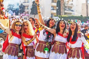
For more than a century, Limassol Carnival has transformed Cyprus’s most vibrant coastal city into a living theatre of sound, colour, and movement. For eleven days each year, folk melodies drift through narrow streets, masked dancers fill public squares, and spontaneous celebrations blur the boundaries between tradition and spectacle. The carnival is not simply entertainment. It is one of Cyprus’s most enduring expressions of community identity, cultural memory, and joyful defiance of everyday routines. A City That Moves to Its Own Rhythm Limassol has long been known for its outward-looking character. As Cyprus’s main coastal trading hub, the city absorbed influences from Greece, Venice, the Middle East, and beyond. Carnival became the moment when these influences merged into a shared urban identity, expressed most vividly through music and dance. Unlike many European carnivals that focus primarily on visual spectacle, Limassol’s celebration is driven by sound and motion. The city becomes kinetic and audible, with mandolins echoing in alleyways, percussion groups pulsing through neighbourhoods, and folk dancers sharing streets with samba troupes. For a brief period each year, Limassol does not host the carnival. Limassol becomes the carnival. From Ancient Rituals to Urban Festivity Carnival traditions in Cyprus trace their roots to pre-Christian spring rituals associated with renewal, fertility, and the Dionysian cycle of life. Masks, role reversal, and theatrical performances…
Read more