Explore Cyprus with Our Interactive Map

Explore our top stories and discover ideas worth your time.

Modern Naval Heritage

Modern Naval Heritage

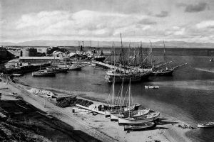
Cyprus has never treated the sea as a boundary. For centuries, its coastline functioned as a working edge where trade, defense, administration, and daily life met. In the modern period, this relationship was shaped most clearly by two naval powers: the Ottoman Empire and the British Empire. Their presence did not simply leave behind forts and harbors. It reshaped how the island was governed, how its ports functioned, and how Cypriots understood their place within the wider Mediterranean world. This article explores how Ottoman and British naval priorities transformed Cyprus from a regional outpost into a strategic maritime asset, and why that legacy still defines the island’s identity today. An Island Positioned to Be Watched Cyprus sits at a crossroads of the eastern Mediterranean, close enough to Anatolia, the Levant, and Egypt to matter to every power operating in the region. This geography made neutrality impossible. Control of Cyprus meant visibility over key sea lanes, access to sheltered anchorages, and influence across multiple trading and military routes. Rather than isolating the island, the sea connected it outward. Cyprus became valuable not for its interior alone, but for how its coastline could support movement, surveillance, and supply. This strategic reality explains why naval priorities repeatedly shaped the island’s administration. What “Modern Naval Heritage” Really Means When discussing naval heritage in Cyprus,…

Read more

Agios Lazaros Church Larnaca

Agios Lazaros Church Larnaca

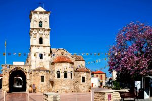
Agios Lazaros Church, located in central Larnaca, is one of the most prominent medieval landmarks in Cyprus. The structure was built in the late 9th or early 10th century over a site traditionally associated with an ancient burial chamber linked to the historical figure Lazarus, a name widely referenced in early Mediterranean religious texts. The building is considered an important example of Byzantine-era architecture on the island and continues to attract interest for its historical, artistic, and archaeological significance. Historical Background According to long-standing tradition, the site is connected to Lazarus, a figure mentioned in early religious writings from the eastern Mediterranean. These traditions describe his arrival in Cyprus during the early centuries AD and his association with the ancient settlement of Kition (modern Larnaca). Historical accounts suggest that during the Arab period (7th–10th centuries), knowledge of the original burial location was gradually lost. In 890 AD, a tomb discovered in Larnaca bearing an inscription referencing Lazarus brought renewed attention to the site. Architectural Features and Transformation Through History The church is built from local limestone and follows a basilica-style plan with three aisles supported by thick stone pillars. The central aisle is covered by domes, while the side aisles use vaulted roofing systems. Originally, the building is believed to have had three domes, a rare architectural feature in Cyprus.…

Read more
Northern Coast Beaches of Cyprus

Northern Coast Beaches of Cyprus

The northern coastline of Cyprus stretches from Morphou Bay in the west to the Karpasia Peninsula in the east, offering over 100 beaches of varied character. Unlike the southern coast dominated by golden sands, the northern shores feature more pebble beaches interspersed with sandy coves and dramatic cliffs. The Kyrenia mountain range, also called the Pentadaktylos or Five Finger Mountains, rises directly behind the coast, creating spectacular backdrops where pine covered peaks descend to turquoise waters.  The northern beaches remain less developed than their southern counterparts, with many small coves hidden behind rock formations requiring exploration to find. This area falls within Turkish controlled Cyprus, accessible through checkpoints from the Republic of Cyprus. The coastline varies dramatically from long stretches of sand at Famagusta Bay and the Karpasia Peninsula to rocky shorelines west of Kyrenia. Alagadi Turtle Beach protects endangered species Alagadi Beach, located approximately 16 kilometers east of Kyrenia near the village of Ayios Amvrosios, ranks among the most important nesting sites in the Mediterranean for loggerhead and green turtles. The beach extends just over 600 meters along the coast with soft golden sand perfect for turtle nesting. From June through September, female turtles come ashore to lay eggs in the dunes, with each nest containing 80 to 120 eggs.  The Alagadi Turtle Beach Project operates a conservation initiative…

Read more