Explore Cyprus with Our Interactive Map

Explore our top stories and discover ideas worth your time.

Cyprus Museum Nicosia

Cyprus Museum Nicosia

The Cyprus Museum stands on Museum Street in central Nicosia as the oldest and largest archaeological museum in Cyprus. Founded in 1882 during British occupation, the museum houses the most extensive collection of Cypriot antiquities in the world. The institution displays only artifacts discovered on the island, creating a focused narrative of Cyprus's archaeological heritage from the Neolithic period through the Roman era.  The museum building itself carries historical importance, with construction commencing in 1908 and completing in 1924 when Cyprus remained a British colony. Extensions added in 1961 created additional galleries, storerooms, and offices that surround a central square area housing auxiliary offices, a library, and laboratories for preserving and studying items. Fourteen display halls follow chronological and thematic succession, though the collection has far outgrown existing capacity with only a small fraction on display at any time. How a petition saved Cyprus's heritage The museum was founded following a petition delivered to British authorities by a delegation headed by religious leaders of both Christian and Muslim populations. The catalyst for this action was several illicit excavations and the smuggling of antiquities off the island during the early British period.  Cypriots recognized that their archaeological heritage was disappearing to foreign museums and private collections, prompting joint action across religious communities. The British administration agreed to establish a central repository…

Read more
Cyprus Grazing Lands and Stone Houses

Cyprus Grazing Lands and Stone Houses

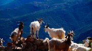
Cyprus agricultural landscape combines traditional shepherding practices with distinctive stone architecture that has defined rural life for centuries. Grazing land occupies approximately 16,369 hectares, representing 4.95% of the total land area in the Turkish-occupied part of Cyprus. These pastures support sheep and goat herding that dates back to the Neolithic period around 8000 BC, making Cyprus one of the earliest locations for domesticated livestock management. Stone houses built from locally quarried limestone stand as physical monuments to village life and family continuity. The thick walls, small windows, and vaulted ceilings reflect adaptations to Mediterranean climate while using materials readily available from surrounding terrain. These structures remain intimately connected to the agricultural economy they supported for generations. Shepherding Methods Adapted to Island Terrain Traditional Cypriot sheep and goat herding operates on small to medium scales with short-range mobility. From October through June during rainy seasons, herds relied on wild plants in scrublands, hilly areas, and fallow land. In predominantly mountainous regions, especially around Lemesos and Pafos districts, goats continued year-round grazing. This pattern demonstrated remarkable adaptation to landscape variations and climate cycles. British colonial law in 1913 excluded goats from extensive upland forest areas to protect tree regeneration. Only tethered goats received permission in those zones. This restriction fundamentally altered traditional grazing patterns and concentrated herds in lowland areas. The law…

Read more
Ayia Napa Lover’s Bridge

Ayia Napa Lover’s Bridge

The Lover's Bridge stands as one of Cyprus's most photographed natural landmarks. This limestone arch extends from the coastal cliffs near Ayia Napa, reaching toward the Mediterranean Sea with one end firmly anchored to land while the other dips into crystal-clear turquoise water. The bridge measures approximately 6 meters long and half a meter wide, formed entirely through natural processes without any human construction. Visitors from around the world come to walk across this slender natural formation, particularly during sunset hours when golden light transforms the white limestone and azure water into a scene of remarkable beauty. The bridge takes its name from romantic traditions that have developed around the site. Local legend claims that couples who kiss while standing in the middle of the arch and make a wish together will see their wishes come true. This belief has made the location a popular destination for marriage proposals, wedding photographs, and symbolic ceremonies celebrating love and commitment. How Wave Action Sculpted the Arch The Lover's Bridge formed through a combination of mechanical and chemical erosion acting on limestone bedrock. Rainwater absorbs carbon dioxide from the atmosphere and soil, creating a weak carbonic acid solution. When this slightly acidic water contacts limestone, it triggers chemical reactions that gradually dissolve the calcium carbonate rock. Seawater contains additional dissolved salts and compounds…

Read more