Explore Cyprus with Our Interactive Map

Explore our top stories and discover ideas worth your time.

Amathus Roman Remains Cyprus Coastal City Life

Amathus Roman Remains Cyprus Coastal City Life

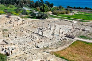
The ruins of Amathus spread across a coastal hillside 11 kilometers east of Limassol, where stone walls and column fragments mark one of Cyprus' oldest city kingdoms. Archaeological evidence shows continuous occupation from 1100 BCE until the 7th century CE, a span of nearly 2,000 years. During the Roman period, Amathus became the capital of one of four administrative regions on Cyprus. The city's importance grew so significant that Romans used the term Amathusia as a general synonym for Cypriot. Today, visitors walk through the remains of public baths built during Emperor Hadrian's time, explore an agora where merchants traded goods from across the Mediterranean, and view foundations of the great Temple of Aphrodite that made this the second most important worship site for the goddess on her homeland island. Below the waves, 60 meters from shore, lie the stone moles of a Hellenistic harbor built during conflicts between Alexander the Great's successors. This combination of land and underwater remains provides a complete picture of ancient coastal city life. Historical Background The Roman bath complex at Amathus sits adjacent to what was once the central agora or marketplace. Constructed in the 2nd century CE during a period of public improvements commissioned by Emperor Hadrian, the baths demonstrate typical Roman bath design adapted to the Cyprus climate. The structure forms a…

Read more
Cavo Greco Sunrise Viewpoint, Cyprus

Cavo Greco Sunrise Viewpoint, Cyprus

The Cavo Greco sunrise viewpoint sits at the southeastern edge of Cyprus, positioned at 95 meters above sea level on a small limestone mountain within Cape Greco National Forest Park. This protected area spans 385 hectares between the resort towns of Ayia Napa and Protaras. The viewpoint marks the easternmost point of both the Republic of Cyprus and the European Union, offering unobstructed panoramas of the Mediterranean Sea, Famagusta Bay, and the surrounding coastline. Visitors come here primarily for the spectacular sunrise displays that occur daily, with the sun rising directly from the sea in vibrant colors that illuminate the limestone cliffs and turquoise waters below. Historical Background The limestone cliffs and formations seen today were created through a combination of tectonic activity and the erosive forces of the sea and wind over millions of years. The karst topography has produced numerous caves and natural arches throughout the area. The cape was known as Cape Pedalion in antiquity, and according to Strabo the trapezoidal hill lying above it was sacred to Aphrodite. Archaeological evidence shows the area has been inhabited since Neolithic times, with one of the oldest settlements in Cyprus discovered here in 1992. Cape Greco was designated as a National Forest Park in 1993 to preserve its unique ecosystems and prevent further degradation. Between 1910 and 1920, the…

Read more
Spilia Tis Athasias Hiking Trail

Spilia Tis Athasias Hiking Trail

The Spilia Tis Athasias Nature Trail is a pristine woodland route tucked away in the mountainous region of the Larnaca District in Cyprus. Known to the local community as the Moutti tis Athasias Trail, this route is one of the most serene and peaceful options for hikers exploring the higher reaches of the island. What makes the trail distinct is the seamless transition from an open panoramic path to a dense pine woodland. The journey culminates at a historic mining cave dating back to the Venetian era, offering a combination of pure natural beauty and historic intrigue. Trail Overview Location: Near Vavatsinia Village, Larnaca District Distance: 2.25 km (1.4 miles) one-way / 4.5 km (2.8 miles) out-and-back Route Type: Linear (Out-and-Back) Technical Difficulty: Easy to Moderate Duration: 1 to 1.5 hours total (round trip) Elevation Gain: 120–200 m (390–650 ft approx.) Maximum Altitude: 1,000–1,040 m (3,280–3,410 ft) Best Time to Visit: March – May and October – November Detailed Analysis of the Route Experience The Initial Forest Road Stage The journey begins on a wide, loose-surface gravel farm road. This first section covers approximately 1.5 kilometers of the hike. Because it is a repurposed rural access road, the terrain is quite even and poses very few technical challenges for walkers. The road curves gently around the mountain slope, operating as…

Read more