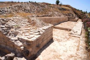
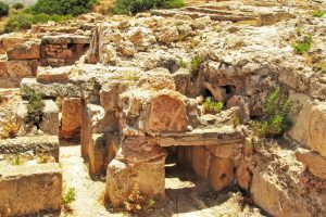
Explore Cyprus with Our Interactive Map

Explore our top stories and discover ideas worth your time.

Karpasia Peninsula Route Cyprus

Karpasia Peninsula Route Cyprus

The Karpasia Peninsula extends like a long finger into the Mediterranean from northeastern Cyprus, reaching 75 kilometers toward Turkey and Syria. This narrow landmass, also known as the Panhandle, represents Cyprus's most remote and undeveloped region. The peninsula covers 898 square kilometers with a population density of just 26 people per square kilometer, making it one of the least inhabited parts of the island. The main route runs from Trikomo, considered the gateway town, through small villages to Cape Apostolos Andreas at the very tip. This wild coastline hosts more than 46 sandy beaches, ancient ruins, and rare wildlife that make the journey one of Cyprus's most rewarding drives. Historical Background The Karpasia Peninsula has supported human settlement since the Late Bronze Age, with archaeological evidence showing continuous habitation for over 3,000 years. Ancient harbor sites near where Hala Sultan Tekke stands today served the town of Kition during its Bronze Age prominence from 1650 to 1050 BC. These coastal areas functioned as crucial trading posts connecting Africa, Asia, and Europe through maritime networks. The ancient city of Karpasia gave the peninsula its name, though only ruins remain today near the modern village of Rizokarpaso. Another major Bronze Age settlement, Afendrika, lies about seven kilometers east of Agios Filon Beach. This city flourished during the second century BC and left…

Read more
Cyprus Venetian Fortifications

Cyprus Venetian Fortifications

The Venetian fortifications of Cyprus represent some of the most impressive defensive structures built during the Renaissance period. Between 1489 and 1571, the Republic of Venice controlled Cyprus and invested heavily in fortifying three major cities: Nicosia, Famagusta, and Kyrenia. These fortifications were designed to protect the island from Ottoman invasion using the latest military engineering techniques of the 16th century. The walls featured pentagonal bastions, thick earthwork ramparts, and deep moats, all adapted for the age of gunpowder artillery. Despite their sophisticated design, these fortifications faced their ultimate test in 1570 when Ottoman forces invaded Cyprus. The siege of Famagusta in particular demonstrated both the strength of Venetian military architecture and the determination of defenders who held out for nearly a year against overwhelming odds. Historical Background Cyprus became a Venetian possession in 1489 when Queen Catherine Cornaro, who had married into the Lusignan royal family of Cyprus, was forced to abdicate and cede the island to Venice. The Republic saw Cyprus primarily as a military base to protect its commercial interests in the Eastern Mediterranean. Venice had been active in Cyprus since around 1000 AD, and the island's location made it valuable for controlling Levantine trade routes. The island also produced profitable cotton and sugar exports. For decades, Venetian governors emphasized the need for better fortifications, but little…

Read more
Papoutsa Nature Trail

Papoutsa Nature Trail

The Papoutsa Nature Trail represents a significant high-altitude route within the Pitsilia region of Cyprus. This path climbs toward the summit of Mount Papoutsa, which stands as the third-highest peak on the island. Hikers traverse a landscape defined by rugged volcanic rock and sparse mountain vegetation. The environment around this trail features a unique mix of endemic plants and geological formations. Local history connects this mountain to the traditional life of the nearby villages like Palaichori and Agros. This area serves as a vital water catchment zone for the southern plains of the island. Visitors encounter a quiet atmosphere that contrasts with the busy coastal resorts. The trail offers a clear view of the surrounding valleys and the distant sea on clear days. This path is a testament to the raw and unyielding beauty of the Cypriot interior mountains. Trail Overview Location: Near Palaichori Village, Pitsilia Region, Cyprus Distance: 4.3 miles (7 km) Route Type: Out & Back Difficulty: Hard Elevation Gain: 550 meters Duration: 3 – 4 hours Best Time to Visit: March – May and September – November Terrain: Rocky, steep mountain slopes, and dirt tracks Geological Composition and Volcanic Origins The ground beneath the Papoutsa Nature Trail consists of ancient volcanic material from the Troodos ophiolite complex. This rock formed millions of years ago on the deep…

Read more