Explore Cyprus with Our Interactive Map

Explore our top stories and discover ideas worth your time.

Akamas Peninsula Cliffs and Headlands Cyprus

Akamas Peninsula Cliffs and Headlands Cyprus

The Akamas Peninsula juts into the Mediterranean Sea at Cyprus's northwestern tip, covering 230 square kilometres of protected wilderness. Akamas represents the last significant untouched coastal area on Cyprus, a roadless peninsula where development remains minimal and natural processes continue largely undisturbed. chooseyourcyprus.com The area extends from the town of Peyia in the south to Polis Chrysochous in the northeast, with the actual headland pointing west into open Mediterranean waters. Unlike most of Cyprus, which shows clear evidence of thousands of years of human modification, Akamas retains a wild character through a combination of difficult terrain, limited water resources, and protective designations. Until 2000, the British Army used Akamas as a training ground and firing range under the 1960 Treaty of Establishment, which allowed up to 70 days of annual military exercises. This restricted access inadvertently preserved natural habitats by preventing agricultural expansion and tourist development. When military use ended, conservation groups successfully argued for maintaining protection through different legal mechanisms. Historical Background Geological processes spanning millions of years created Akamas's distinctive terrain. Limestone formations dominate, deposited when seas covered the region during various periods. Tectonic uplift raised these sediments above sea level, creating the elevated plateau that characterizes the interior. Erosion carved gorges and sea caves where water cut through softer rock layers, exposing cross-sections of geological history. The…

Read more
Kyrenia Castle: Fortress Facing the Sea

Kyrenia Castle: Fortress Facing the Sea

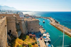
Kyrenia Castle stands at the edge of one of Cyprus’s most sheltered harbours, where land and sea have negotiated power, trade, and survival for centuries. Unlike hilltop fortresses built to dominate territory from afar, this castle was designed to watch the water closely. Its purpose has always been practical: to protect the harbour, control movement, and adapt to whoever ruled Cyprus at the time. That continuous adaptation rather than a single defining moment is what gives Kyrenia Castle its lasting significance. Adobe-Stock-com A Fortress Built for a Living Harbour Kyrenia Castle occupies a narrow strip of land between the town and the sea, positioned so that every vessel entering the harbour passes beneath its walls. From its earliest days, the castle was inseparable from daily life. Trade ships, fishing boats, and naval vessels all moved through the same space, watched over by stone walls that were never purely symbolic. Adobe-Stock-com This closeness to the harbour distinguishes Kyrenia Castle from many medieval fortifications. It was not a distant refuge, but an active participant in the rhythms of the town. Its defensive role was intertwined with commerce, communication, and maritime control. Byzantine Foundations and the First Line of Defence The earliest phase of Kyrenia Castle dates to the Byzantine period, when coastal settlements across the Eastern Mediterranean were reinforced against Arab naval…

Read more
Ancient Idalion Dali – City-Kingdom & Idalion Tablet

Ancient Idalion Dali – City-Kingdom & Idalion Tablet

Idalion was an ancient city in Cyprus, in modern Dali, Nicosia District. The city was founded on the copper trade in the 3rd millennium BC. Located in the fertile Gialias valley between two hills, this powerful kingdom left behind one of the most important historical documents in ancient Cyprus, a bronze tablet that recorded a social welfare system 2,500 years old. wikimedia.org1 The ancient city was located in the fertile Gialias valley and flourished there as an economic centre due to its location close to the mines in the eastern foothills of the Troodos Mountains and its proximity to the cities and ports on the south and east coast.Idalion prospered and became so wealthy that it was listed as the first among the ten Cypriot kingdoms on the prism of the Assyrian king Esarhaddon (680-669 BC). This ranking shows how important the city was in the ancient Mediterranean trade network. Historical Background The ancient city was founded by the Achaean hero of the Trojan war, Chalcanor, descendant of Teucer, the founder of Salamis. This foundation legend connects Idalion to the wave of Greek colonization that followed the Bronze Age collapse around 1200 BC. The worship of Apollo Amyclae reveals that the Greeks came from Laconia. This detail shows that the settlers originated from the Peloponnese in southern Greece, bringing their…

Read more