Explore Cyprus with Our Interactive Map

Explore our top stories and discover ideas worth your time.

Roman Road Network Ancient Cyprus Routes

Roman Road Network Ancient Cyprus Routes

Cyprus already had roads before the Romans arrived. The earliest routes date back to the Bronze Age, and by the end of the Hellenistic period, a road network circled the entire island. These pre-Roman roads connected cities with their surrounding territories and linked major settlements along the coast. However, they were often simple tracks suitable for pedestrians and pack animals rather than the engineered highways Romans built elsewhere in their empire. pixabay-com When Cyprus became a Roman province in 22 BC under Emperor Augustus, the new administration inherited this existing network. The Romans added secondary roads and improved certain routes, but they did not rebuild the entire system to match the standards used in Italy or other provinces. This practical approach reflected Cyprus's geography and peaceful status. The island was stable enough not to require a large military presence, so the roads served primarily civilian purposes rather than rapid military deployment. Augustus and later Emperor Titus are credited in inscriptions as the creators of the formal Roman road system on Cyprus. The roads they established formed part of the imperial network, meaning they received official recognition and maintenance funding from Rome itself. How the Road System Worked The main roads formed a coastal highway that encircled the island, connecting all major cities. From this primary route, secondary roads branched inland…

Read more
Modern Naval Heritage in Cyprus

Modern Naval Heritage in Cyprus

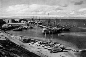
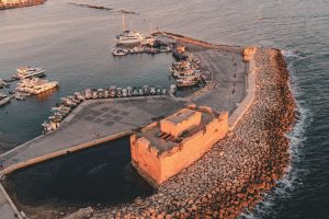
Cyprus has never treated the sea as a boundary. For centuries, its coastline functioned as a working edge where trade, defense, administration, and daily life met. In the modern period, this relationship was shaped most clearly by two naval powers: the Ottoman Empire and the British Empire. Their presence did not simply leave behind forts and harbors. It reshaped how the island was governed, how its ports functioned, and how Cypriots understood their place within the wider Mediterranean world. globalgrasshopper-com This article explores how Ottoman and British naval priorities transformed Cyprus from a regional outpost into a strategic maritime asset, and why that legacy still defines the island’s identity today. An Island Positioned to Be Watched Cyprus sits at a crossroads of the eastern Mediterranean, close enough to Anatolia, the Levant, and Egypt to matter to every power operating in the region. This geography made neutrality impossible. Control of Cyprus meant visibility over key sea lanes, access to sheltered anchorages, and influence across multiple trading and military routes. Rather than isolating the island, the sea connected it outward. Cyprus became valuable not for its interior alone, but for how its coastline could support movement, surveillance, and supply. This strategic reality explains why naval priorities repeatedly shaped the island’s administration. What “Modern Naval Heritage” Really Means When discussing naval heritage in…

Read more
Nea Paphos Harbor

Nea Paphos Harbor

Nea Paphos emerged as one of the most strategically important harbor cities in the ancient Mediterranean. Founded in the late 4th century BC on the southwest coast of Cyprus, this planned city replaced the older settlement of Palaipaphos and quickly became the island's capital. touriste-ru The harbor served dual purposes as both a major naval base and a thriving commercial port, connecting Egypt with the broader Mediterranean world. Today, the archaeological remains spread across 100 hectares near modern Kato Paphos, offering a window into ancient maritime power. Historical Background King Nikokles, the last monarch of Palaipaphos, founded Nea Paphos around 320 BC. After Alexander the Great's death, Cyprus fell under Ptolemaic Egyptian control in 294 BC, where it remained for over 250 years. The site offered exceptional advantages. The city occupied a peninsula between two hills, with a natural bay providing shelter from storms. Strabo reported that the harbor offered protection from winds in all directions. Nearby forests supplied abundant cedar wood for shipbuilding, while the location sat on the critical maritime route between Rhodes and Alexandria. tripadvisor-ru Urban planners designed Nea Paphos according to the Hippodamian grid system, heavily influenced by Alexandria. Regular streets intersected at right angles, creating rectangular blocks called insulae. Defensive walls separated the urban area from the mainland, while public buildings faced the large harbor.…

Read more