Explore Cyprus with Our Interactive Map

Explore our top stories and discover ideas worth your time.

Mount Olympus Cyprus

Mount Olympus Cyprus

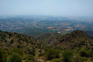
Mount Olympus, also called Chionistra in Greek, represents the highest point on an island better known for beaches than mountains. The peak sits within the Troodos range, a vast expanse of pine forests, rocky slopes, and endemic wildlife that covers roughly a third of Cyprus. Unlike its famous Greek namesake associated with Zeus and the ancient gods, Cyprus's Olympus tells a different story through geology, nature, and seasonal transformation. alamy-com The mountain serves multiple purposes throughout the year. In winter, it becomes the only ski destination in Cyprus. During warmer months, hikers take to trails that wind through black pine forests and offer panoramic views across the entire island. The summit itself houses British and Cypriot radar stations, making the actual peak off limits to visitors, but numerous viewpoints just below provide spectacular perspectives of the surrounding landscape. Historical Background Mount Olympus formed approximately 92 million years ago as part of the Troodos Ophiolite Complex, an uplifted fragment of ancient oceanic crust from the prehistoric Tethys Ocean. The mountain's core consists of ultramafic rock, primarily serpentinized harzburgite, which represents exposed upper mantle from deep beneath an ancient seabed. Tectonic forces pushed this oceanic crust upward through a process called obduction, eventually lifting it above sea level to create the island's mountain spine. This geological origin makes Troodos globally significant among…

Read more
Salt Lakes Nature Reserve Cyprus Larnaca Akrotiri

Salt Lakes Nature Reserve Cyprus Larnaca Akrotiri

Cyprus is home to two major salt lake systems that serve as crucial stops for thousands of birds during their migration between Europe and Africa. The Larnaca Salt Lake complex lies near the island's southeastern coast, while the Akrotiri Salt Lake sits southwest of Limassol. Both wetlands hold international ecological significance and attract up to 20,000 flamingos each winter, along with dozens of other bird species. shutterstock-com The Larnaca Salt Lake Complex The Larnaca Salt Lake consists of four interconnected salt lakes covering 1,761 hectares southwest of Larnaca town. The largest lake is called Aliki, followed by Orphani, Soros, and the smallest, Airport Lake. The Airport Lake was separated from Orphani when Larnaca International Airport's runway was built, cutting it off from the main complex. The lakes measure 2.2 square kilometers total and sit just off the road to Larnaca International Airport, making them one of the area's most recognizable landmarks. Water depth reaches a maximum of one meter during winter. The lakes fill with water during the rainy season from November through March, then dry completely by summer, leaving exposed salt flats. trapvisitor-com During winter, between 2,000 and 12,000 greater flamingos arrive at Larnaca Salt Lake to feed on abundant brine shrimp. The dark red algae in the lake forms the base of the food chain, as the small…

Read more
Toumba tou Skourou

Toumba tou Skourou

Near the town of Morphou in northwestern Cyprus, an artificial hill once rose from the fertile plain where the Ovgos River flows toward the sea. For over 600 years during the Bronze Age, this spot was home to potters who made beautiful ceramics, copper workers who processed metal from nearby mines, and families who buried their dead in tombs cut into the rock. Bulldozers destroyed much of the site before archaeologists could study it, but what they found in three short years changed how we understand Bronze Age Cyprus. visitcyprus-com Historical Background Toumba tou Skourou was a Late Bronze Age settlement and cemetery located 4 kilometers from central Morphou on Cyprus's northwestern coast. The name means "Mound of Darkness" in Greek, though scholars debate where this unusual name came from. The site consisted of an artificial mound about 10 meters high, 12 meters wide, and 20 meters long, created from the accumulated debris of centuries of human activity. wikimedia-org The settlement flourished from the Middle Bronze Age through the Iron Age, roughly 1650 BC to 750 BC. During its peak, Toumba tou Skourou functioned as an industrial center where craftspeople made pottery and processed copper from mines in the nearby Troodos Mountains. The site also contained residential areas, storage buildings with large pithoi (clay jars), and at least six chamber…

Read more