Explore Cyprus with Our Interactive Map

Explore our top stories and discover ideas worth your time.

Ancient Terraces and Orchards in Cyprus Mountains

Ancient Terraces and Orchards in Cyprus Mountains

The mountains of Cyprus hold secrets carved into their slopes. For thousands of years, people built stone terraces across steep hillsides, creating agricultural systems that still influence the landscape today. These terraces supported orchards and crops in places where farming seemed impossible, showing the remarkable skill of ancient communities in managing their environment. chooseyourcyprus.com Recent archaeological work reveals that terrace farming on Cyprus dates back at least 3,000 years. The Bronze Age settlement of Politiko-Troullia, occupied between 2050 and 1850 BCE, provides clear evidence of this practice. Located in the foothills of the Troodos Mountains, this village sat at the interface between the fertile Mesaoria Plain and the copper-rich mountains, making it an ideal location for both agriculture and metal production. Historical Background The terraces at Politiko-Troullia were not simple structures. Archaeological surveys identified 168 ancient terrace walls in the study area, constructed with local stone and designed to serve multiple purposes. Longer terrace walls created level plots for agriculture, while shorter walls focused on erosion control and supporting fruit trees. These ancient farmers understood their environment well. They built terraces on slopes with specific geological features, particularly near pillow lavas and limestone deposits where sediment availability and water drainage were optimal. Surface geology played a crucial role in determining where to construct terraces, as the walls needed both stable…

Read more
Kourion Mosaics Apollo To Basilicas Guide

Kourion Mosaics Apollo To Basilicas Guide

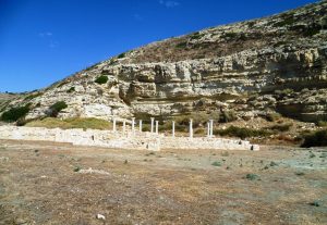
Kourion’s mosaics record Cyprus’s shift from a classical city organised around temples and civic life to an early Christian centre rebuilt under episcopal authority after mid-fourth-century earthquakes. In villas and basilicas, floors and inscriptions became a visual language that guided movement, reinforced belief, and redefined what power looked like in public space. wikimedia-org This article explains how disaster opened the ground for change, how the Episcopal Complex reshaped the city’s core, and how mosaic imagery at sites like the House of Eustolios shows a community rebuilding identity as well as architecture. Apollo Hylates and Old Order For centuries, Kourion thrived as a Greco-Roman city, complete with temples, baths, theatres, and elite villas. Public life revolved around civic institutions and traditional religious cults, most notably the Sanctuary of Apollo Hylates. Christianity was present early, introduced to Cyprus in the first century, but in Kourion it remained largely private and unobtrusive. Everything changed in the mid-fourth century. A catastrophic earthquake, most notably the one in 365 CE, devastated the city. Entire neighbourhoods collapsed, public monuments were abandoned, and the old religious landscape effectively ended. The destruction was not symbolic. It was physical, sudden, and comprehensive. When rebuilding began, it followed a new logic. wikimedia-org Instead of restoring pagan sanctuaries, Kourion was reorganised around Christian authority. The centre of gravity shifted from temples…

Read more
Morphou Plain

Morphou Plain

The Morphou Plain spreads across northwestern Cyprus as the island's most fertile agricultural region. The plain covers several hundred square kilometres of exceptionally productive farmland watered by underground aquifers and seasonal streams. The town of Morphou serves as the region's commercial centre with a current population of approximately 18,000 to 24,000 people. shutterstock-com The area produces over half of Cyprus's citrus fruits, primarily oranges, lemons, and grapefruits, along with substantial quantities of apples, vegetables, melons, and strawberries. The distinctive red soil, rich in minerals and organic matter, creates ideal conditions for intensive agriculture. Unlike much of Cyprus, which struggles with water scarcity, the Morphou Plain benefits from abundant groundwater that allows year-round cultivation and supports the island's most productive farming operations. Historical Background The Morphou region has sustained human settlement since at least the Bronze Age, with archaeological evidence suggesting continuous occupation for over 4,000 years. The fertile soil and reliable water supplies attracted early agricultural communities who recognized the land's exceptional productivity. The ancient city-kingdom of Soli developed on the plain's coastal edge, thriving from approximately the 11th century BC until Arab raids destroyed it in the 7th century AD. facebook-com Soli's prosperity derived from two resources: rich copper deposits in the nearby hills and fertile agricultural lands that fed mining communities and produced surplus for export. According to…

Read more