Phyti Weaving Tradition
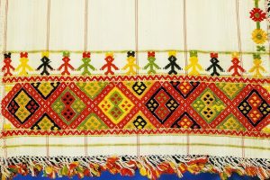
Phyti Weaving Tradition is a distinctive Cypriot craft originating from the village of Phyti, involving highly symbolic woven textiles characterized by bright colors and ritual motifs, originally created for dowries and ceremonial purposes. This handmade art form uses intricate patterns on cotton or linen fabrics to convey themes of protection, fertility, and harmony, passed down through generations of female artisans. Recognized as part of Cyprus's intangible cultural heritage, it embodies the island's blend of ancient symbolism and practical beauty, preserving a legacy of women's creativity in rural life. A Timeless Craft of Color and Symbol Phyti weaving stands as a vibrant expression of Cypriot textile heritage, where artisans produce fabrics adorned with geometric designs and bold hues that hold deep symbolic value. Centered in the village of Phyti in the Paphos District, this tradition focuses on hand-loomed cotton or linen pieces, often in red, blue, and yellow, featuring motifs like diamonds for protection or crosses for faith. These textiles were historically crafted by women for dowries - essential marriage gifts symbolizing a bride's skill and family's prosperity - or ceremonial uses like altar cloths in churches. The craft's emphasis on ritual patterns reflects a worldview where everyday items carried spiritual weight, blending utility with meaning in Cypriot rural life. The process begins with "dafna," a counted thread technique where threads…
Read more