Saints Feast Days in Cyprus
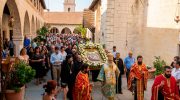
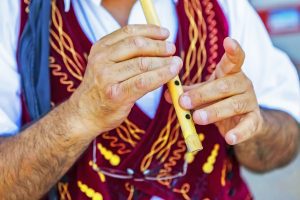
Commemorative days in Cyprus establish the seasonal rhythm of rural life throughout the year, with each community recognizing a historical figure through formal ceremonies and traditional public festivals called panigyria. These events integrate regional customs with large-scale social gatherings, featuring organized walks, artifact displays, communal meals, folk music, and traditional dances that continue until dawn. Unlike various international traditions where individual birthdays are the primary focus, Cypriots emphasize these shared name days with significant social enthusiasm. The regional calendar includes hundreds of these occasions honoring figures from antiquity, the Byzantine era, and more recent local history. Major events like the August 15 commemoration attract thousands to historical landmarks and village squares, while smaller festivals serve to maintain regional identity and ancestral family connections. The panigyri tradition has functioned for centuries as a vital element of Cypriot social culture, earning international recognition for its role in preserving community heritage and local bonds. The Structure of a Traditional Panigyri A typical panigyri begins on the evening before the designated feast day with a formal church service marking the start of the celebration within the traditional liturgical calendar. Residents, expatriates, and visitors gather in the village church for hymns, prayers, and community participation. Following the service, a procession often takes place through village streets where an icon associated with the local tradition is…
Read more