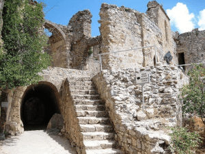
Explore Cyprus with Our Interactive Map

Explore our top stories and discover ideas worth your time.

Tamassos Sacred Valley

Tamassos Sacred Valley

Tamassos was an inland city-kingdom that thrived from the Late Bronze Age to the Roman period, from around 1200 BC to the 10th century AD. The city appears in an Assyrian inscription from about 673 BC as Tamesi, a city-state that paid tribute to the Neo-Assyrian Empire. Homer may have mentioned it in the Odyssey as Temese, described as the main copper market on the island. The archaeological site is next to the modern village of Politiko. Much of the ancient city center has not been excavated because it lies under the village and the nearby Monastery of Saint Herakleidios. Archaeologists have uncovered two large royal tombs from the 6th century BC, the foundations of a temple to Aphrodite, parts of city walls, and signs of extensive copper-processing workshops. Historical Background The region was inhabited since the Chalcolithic Age, and villages in the area were densely populated from the Early Bronze Age. Small farming settlements existed long before Tamassos became a unified city. The discovery and use of copper deposits transformed the farmland into an industrial center. The population grew significantly after the copper mines were exploited. Tombs and copper-processing workshops from the Late Bronze Age show this growth. Tamassos controlled major mines near its capital, like Mavrovouni and Kokkinopezoula, which made it a center of copper production. Classical authors…

Read more
Cape Greco Natural Arch

Cape Greco Natural Arch

Cape Greco's natural arch, known locally as Kamara tou Koraka or "Crow's Arch," stands as one of Cyprus's most remarkable geological features. Located within Cape Greco National Forest Park on the southeastern tip of the island, this limestone bridge stretches over the Mediterranean Sea between the resort towns of Ayia Napa and Protaras. The arch sits alongside a coastal road that winds through the park, where visitors can observe this natural wonder without difficulty. The bridge was formed over millennia by the erosive forces of wind and water, creating a structure that appears both delicate and enduring. How Ancient Seas Created This Natural Bridge The geological story of Cape Greco's natural arch begins millions of years ago when Cyprus was submerged beneath ancient oceans. During the Cretaceous period, Cyprus was situated near the equator and the region was characterized by a warm, shallow sea where the deposition of marine sediments led to the formation of limestone and marl. These calcium carbonate deposits accumulated layer by layer as countless marine organisms died and settled on the seafloor. Cyprus sits near the boundary between the Eurasian and African tectonic plates, a position that has shaped the island's dramatic geology. The collision of these plates triggered gradual uplift, eventually pushing the ancient seabed above water. This uplift continues today at a measurable rate,…

Read more
Cape Aspro Reserve

Cape Aspro Reserve

Cape Aspro is located on the southern coast of Cyprus between Limassol and Paphos. The name translates to "white" in Greek, a fitting description for the dramatic limestone cliffs that tower over 200 meters above the turquoise Mediterranean Sea. This natural reserve offers visitors a unique combination of geological wonder, biological diversity, and outdoor adventure. The white cliffs of Cape Aspro formed over millions of years through natural geological processes. Composed of sedimentary limestone, these formations emerged as wind and sea erosion sculpted the coastline into its current dramatic shape. The cliffs feature caves, arches, and steep edges that create stunning visual contrasts, especially during sunrise and sunset when light reflects off the pale limestone surfaces. These geological formations connect to Cyprus's broader Troodos Ophiolite complex, a rare example where ancient oceanic crust and mantle rock were uplifted through tectonic activity approximately 90 million years ago. Today, visitors can see rocks that once existed more than 20 kilometers below the ocean floor, now exposed and accessible along the coastal trails. Network of Trails Leads to Panoramic Views The reserve features seven interconnected color-coded trails, with routes ranging from 3.5 kilometers to 12.3 kilometers in total distance. These paths wind along cliff edges and through the rugged coastal terrain, with the longest trail reaching approximately 10 kilometers when including the return…

Read more