Explore Cyprus with Our Interactive Map

Explore our top stories and discover ideas worth your time.

Cape Greco Sea Cliffs And Caves

Cape Greco Sea Cliffs And Caves

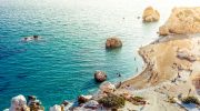
Cape Greco rises from the Mediterranean Sea at Cyprus's southeastern tip, where limestone cliffs drop sharply into turquoise waters, and erosion has carved spectacular sea caves that extend up to 80 metres into solid rock. Cape Greco, also known as Capo Greco or Kavo Greko, forms a rocky peninsula jutting into the Mediterranean between the resort towns of Ayia Napa and Protaras. The headland marks the easternmost point of both the Republic of Cyprus and the European Union, excluding outlying territories. The area covers 385 hectares protected as National Forest Park under the Cyprus Forestry Department since 1993, with additional recognition as part of the Natura 2000 network for its European ecological significance. Historical Background The limestone cliffs at Cape Greco formed from sediments deposited when shallow seas covered the region millions of years ago. Marine organisms including mollusks, corals, and microscopic creatures contributed calcium carbonate that accumulated on the seabed and eventually compressed into rock layers. Tectonic activity lifted these sediments above sea level, creating the elevated plateau that characterizes the cape today. Wave erosion shaped the detailed features that make Cape Greco distinctive. Constant pounding by Mediterranean storms exploits weaknesses in the limestone, gradually hollowing out caves, cutting through narrow points to form arches, and creating vertical channels where waves compress and release with explosive force. This process…

Read more
Ottoman Sebils Public Water Fountains

Ottoman Sebils Public Water Fountains

When the Ottoman Empire took control of Cyprus in 1571, the island experienced major changes in its architecture and daily life. Among the most practical contributions the Ottomans brought were sebils, public water fountains that became essential features of Cypriot cities. These structures served both religious and civic purposes, providing free drinking water to travelers and locals while allowing Muslims to perform ritual ablutions before prayer. The word sabil comes from the Arabic root meaning to make available or to provide a way. In Islamic tradition, building a sabil was considered an act of charity, a way to earn religious merit by serving the community. The Ottoman authorities valued these fountains so highly that they granted tax exemptions to anyone who built a public sabil, provided they kept water available for travelers at all times. Historical Background Ottoman sebils were not just simple fountains. They were carefully designed structures that combined function with beauty. The typical sabil featured a small kiosk where an attendant stood behind a grilled window, handing out cups of water to passersby. Some sebils were standalone buildings at busy street corners, while others were attached to mosques or caravanserais. The architectural style of Sebils varied across the empire. In Istanbul, elaborate sebils appeared during the Tulip Period in the early 18th century, decorated with intricate carvings,…

Read more
Cyprus Coastal Ecosystem Protection

Cyprus Coastal Ecosystem Protection

Cyprus sits in the Eastern Mediterranean, home to some of the most diverse ecosystems in the region. The island features dramatic contrasts, from the Troodos Mountains reaching 1,952 meters at Mount Olympus to extensive coastal zones with unique marine habitats. These environments support rare species found nowhere else on Earth, while 29% of terrestrial and marine areas currently fall under protected status. The island's location between three continents has created a biodiversity hotspot where European, Asian, and African influences converge. Historical Foundation of Conservation Efforts Cyprus joined the European Union in 2004 and faced the challenge of adjusting conservation strategies to meet EU obligations. Before this milestone, the island had limited formal protection mechanisms. The first LIFE Nature project financed in Cyprus aimed to move the country forward in protecting Sites of Community Interest. This marked a turning point, as Cyprus began implementing structured management plans and established monitoring systems. The framework now operates under multiple international agreements, including the Bern Convention, the Barcelona Convention, and EU directives that set specific conservation targets. Defining Features of Protected Areas Cyprus's protected network encompasses 63 Natura 2000 sites covering 1,760 square kilometers. The system includes Special Areas of Conservation, Sites of Community Interest, and Special Protection Areas. Rocky habitats show the highest proportion of good conservation status at 80%, while dune habitats…

Read more