Mesaoria Plain Cyprus Agricultural Heartland
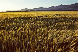
The Mesaoria Plain stretches 96 kilometres across central Cyprus between two mountain ranges. Mesaoria, meaning "between the mountains" in Greek, is a broad central plain that extends from Morphou Bay in the west to Famagusta Bay in the east. The Troodos Mountains rise to the south, while the Kyrenia Range forms a wall to the north. The plain covers approximately 1,000 square kilometres with elevations ranging from 100 metres on average up to 325 metres at its highest points. wikimedia-org Nicosia, the capital of Cyprus, sits roughly in the centre of the plain along the Pedieos River. This positioning reflects centuries of strategic thinking, as the location provided access to both coasts. The plain contains dozens of villages and several major towns, making it the most densely populated region on the island despite its harsh summer climate and winter-dependent water supply. Historical Background Twenty million years ago, Cyprus existed as two separate islands corresponding to what would become the Kyrenia and Troodos mountain ranges. Approximately one million years ago, tectonic forces pushed up the land between these islands, creating the Mesaoria Plain and joining them into the single landmass known today as Cyprus. The Mediterranean Sea covered and exposed the plain multiple times as sea levels changed, but it has remained in its current form since the end of the…
Read more