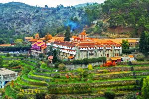
Akrotiri Environmental Protected Area, Cyprus
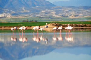
The Akrotiri Peninsula stands at the southernmost tip of Cyprus, where wetlands, salt lakes, and coastal habitats create one of the most important wildlife sanctuaries in the Mediterranean. This protected area combines ancient traditions with modern conservation to safeguard a landscape that supports rare species found nowhere else on Earth. tripadvisor.com Akrotiri Peninsula covers 60 square kilometers within the British Sovereign Base Area, just southwest of Limassol. The area centers around the Akrotiri Salt Lake, Cyprus's largest aquatic system, surrounded by coastal dunes, Mediterranean juniper forests, saltmarshes, and reedbeds. It holds designations as a Ramsar Wetland of International Importance, a Special Protection Area for birds, and a Special Area of Conservation. Historical Background Thousands of years ago, Akrotiri existed as an island separated from Cyprus. The Kouris River carried sediment to its delta over millennia, building up land that formed a bridge connecting the western side to the mainland. Later, a second bridge formed on the eastern side from sediment deposited by the Garilis River. This double tombolo formation trapped the salt lake in the center and took at least 56,000 years to complete. A Remarkable Concentration of Wildlife The peninsula hosts over 800 plant species, representing 40 percent of all plants found on Cyprus. About 300 bird species use the area, with 70 percent of Cyprus's entire bird population…
Read more